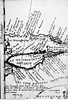
Teiaiagon

Teiaiagon was a village of 50 long houses that existed in the 17th and 18th centuries. His remains are in the Canadian metropolis of Toronto , at the intersection of Jane and Annette Streets in the Baby Point community .
The name means across the river . In the sources the place also appears as Taiaiako'n , Taiaiagon , Teyeyagon or Toioiugon . It was known to the first Europeans in the early 17th century as an Indian village on the east bank of the Humber River ; they estimated the population at 5000.
history
When the village was built is unknown. According to Percy Robinson's Toronto During the French Regime , it was used jointly by the Iroquois, more precisely by Seneca and Mohawk . In contrast, Helen Tanner shows in her Atlas of Great Lakes Indian History a Seneca village at this point, at least for the years 1685–1687. What is certain is that around 1696 it was in the possession of the Mississauga, who do not belong to the Iroquois.
It has often been said that Étienne Brûlé came through Teiaiagon in 1615, but this is now doubted. La Salle passed the place in 1681 and 1682 on his travels westwards. The missionary Louis Hennepin estimated the population of the village at 5,000. Accordingly, they were distributed over 50 longhouses.
1687 attacked the Marquis de Denonville together with several hundred Christian converts, the Seneca in the area of the later state of New York. On the way back he moved along the north shore of Lake Ontario towards Fort Frontenac. What is certain is that he stopped at the Humber and in the neighboring village of Ganatsekwyagon. His Indian allies had probably already taken power there. It is obvious that the Seneca left their villages north of Lake Ontario to provide aid in the south, but this is not certain. Therefore, destruction by the French marquis is uncertain. In any case, the Mississauga initially displaced the Iroquois from southern Ontario until they returned after the independence of the USA. Teiaiagon is no longer mentioned after 1688, but the name still appears on European maps for around 60 years.
With the Great Peace of Montréal (1701), trade in the region increased again strongly. The French placed a small garrison in the village. It stayed from 1720 to 1730, then moved further downstream. In 1750 the French took over the village again from the Mississauga and built a fort at what later became Baby Point. The Mississauga, for their part, lived just as little in the village as the French. Instead, they lived on the opposite, western side of the river (near Old Mill Road and Bloor Street) from 1788 to 1805.
James Bâby from Detroit bought the land in 1816. Hence the name Baby Point established itself . He maintained orchards on the grounds of the abandoned village. The government later bought the land for barracks and a fortress, but later sold it again. The new owner was Robert Home Smith, who developed the site from 1912. Although the place has long been known as an Indian settlement, a memorial plaque was not put up until 1949.
literature
- Percy James Robinson: Toronto During the French regime: A History of the Toronto Region from Brulé to Simcoe, 1615-1793 , The Ryerson press, 1933.
Web links
- Teiaiagon
- A History of Toronto ( December 19, 2010 memento on the Internet Archive )
Remarks
- ↑ Wayne Reeves, Christina Palassio: HTO: Toronto's water from Lake Iroquois to lost rivers to low-flow toilets , p. 50.
- ^ Tanner, Helen Hornbeck et al .: Atlas of Great Lakes Indian History, University of Oklahoma Press 1987, p. 33.
- ↑ He probably avoided the Iroquois, who settled north of Lake Ontario, extensively. Cf. Did Étienne Brûlé Visit Toronto in 1615?
- ↑ Percy James Robinson: Toronto During the French Regime: A History of the Toronto Region from Brulé to Simcoe, 1615-1793 , The Ryerson press, 1933, pp. 14ff.
- ^ Leroy V. Eid: The Ojibwa-Iroquois War: The War the Five Nations Did Not Win , Ethnohistory 26.4 (Fall 1979), Duke University Press, pp. 297-324.
- ^ Peter S. Schmalz The Ojibwa of Southern Ontario , University of Toronto Press 1991, pp. 21f.
- ↑ A photo of the board can be found here .