Tempe Town Lake
| Tempe Town Lake | ||
|---|---|---|

|
||
| Geographical location | Tempe , Arizona | |
| Tributaries | Salt River | |
| Drain | Salt River | |
| Data | ||
| Coordinates | 33 ° 25 '56 " N , 111 ° 55' 55" W | |
|
|
||
| Altitude above sea level | 350 m | |
| surface | 90 ha | |
| Maximum depth | 5 m | |
| Middle deep | 3 m | |
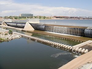
The Tempe Town Lake is an artificial lake in Tempe in Maricopa County in the US state of Arizona . It has an area of 0.9 km². The average depth is 3 meters and the maximum depth is 5 meters. It lies at an altitude of 350 m. ü. M. The lake is traversed by the Salt River .
The lake is spanned by a number of bridges.
history
At the end of July 2020, after a train accident, there was a fire and partial collapse of one of the railway bridges. The Union Pacific Salt River Bridge , Phoenix Subdivision was affected .
