
Teufelsschlucht (Switzerland)
The Teufelsschlucht (dialect: Tüfusschlucht ) is a karst gorge in the area of the municipality of Hägendorf at the southern foot of the Jura . The Cholersbach , a tributary of the Dünnern, flows in the gorge .
Surname
The gorge, called Teufelsgraben or Cholersbachgraben in old maps and documents , has been listed on the Swiss national map since 1955 using the local dialect term Tüfelsschlucht .
geology
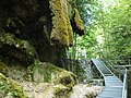
The chain Jura , which has a strong relief and comprises several mountain chains that lie one behind the other and are subdivided by faults , thrusts and erosion , is drained by the Cholersbach, which has formed the Devil's Gorge in its lower section over millions of years. The entrance to the Devil's Gorge is in the middle of the village. A footpath leads in many turns over bridges and footbridges, past caves and crevices up to the Allerheiligenberg . The Cholersbach leads its water over waterfalls and smoothly ground rock slabs into the village and flows into the Dünnern at the village boundary to Kappel.
history
In 1902 the Hägendorf Transport and Improvement Association (VVH) opened up the gorge with a tourist path to the confluence of the Höferbach. The continuation of the footpath from the Höferbächli through the upper gorge to the Allerheiligenberg was realized in 1910 with the opening of the Allerheiligenberg lung sanatorium. The hiking trail is 2,830 meters long and leads over 37 bridges and footbridges.
The geologically interesting gorge is now a nature reserve.
Moss rocks by the tuft fountain
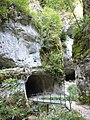
eroded caves

Spray fountain
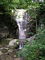
waterfall

Sand hole


literature
- Hägendörfer tree rings 1995 p. 11 ff
- Hägendörfer annual rings 2006 p. 20 ff
- Elisabeth Pfluger : Solothurner Geistersagen , Aare Verlag, Solothurn 1986, ISBN 3-7260-0284-7