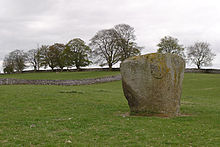
Shap stone row
The Bronze Age stone series of Shap (locally called Shap Stone Avenue) south of the Hill of Skulls and near the stone circles Shap North (Wilson Scar), Shap Center ( Gunnerkeld (also called Kemp Howe)) and South Shap in the south of the village of Shap in Cumbria in England .
The 14 stones in the row usually have names (such as "Gray bull") and form a row of stones oriented approximately southeast-northwest. Some stones are free, others have fallen over. The largest (the Thunder Stone) is a boulder . Most of these stones are hidden between the buildings in the village. All stones are made from local granite and three have markings. The Small Thunderstone has a small dish ( English cup ) and a ring Aspers Field has two dishes, one with a ring, and the Goggleby Stone has a bowl.
That the alignment formed part of a ritual landscape cannot be doubted, although it is difficult to find a context here. Rows of stones are often viewed as processional routes.
literature
- Aubrey Burl: From Carnac to Callanish. The Prehistoric Stone Rows and Avenues of Britain, Ireland, and Brittany. Yale University Press, New Haven CT et al. 1993, ISBN 0-300-05575-7 .
- Jürgen E. Walkowitz: The megalithic syndrome. European cult sites of the Stone Age (= contributions to the prehistory and early history of Central Europe. Vol. 36). Beier & Beran, Langenweißbach 2003, ISBN 3-930036-70-3 .
Web links
Coordinates: 54 ° 31 ′ 48.7 " N , 2 ° 41 ′ 2" W.

