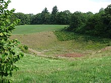
Dead ice hole wolf pit
The Toteisloch Wolfsgrube is a cauldron-like pit near Wildenroth , a district of the Grafrath community in the Upper Bavarian district of Fürstenfeldbruck in Bavaria .
location
The Toteisloch is located 800 meters east of Wildenroth. It is designated as a natural monument and part of the Obere Amper landscape protection area .
description
With a diameter of more than 100 meters and a depth of over 20 meters, the Wolfsgrube is an impressive dead ice hole . Its steep walls are striking. According to tradition, this kettle-like hollow shape was previously used as a trapping pit for wolves . Hence the name Wolfsgrube comes from .
The Wolfsgrube was created towards the end of the last glacial period on the edge of the Isar-Loisach glacier . Here, an ice block detached itself from the actual glacier and was covered with debris and debris as so-called dead ice . When the ice melted, the steep-walled and kettle-like depression of the dead ice hole remained.
In the age of the Quaternary about 2.6 million years ago, climatic fluctuations led to an alternation of warm and cold periods. During the warm periods, the climatic conditions were similar to those today. Only the highest elevations in the Alps were glaciated. The average temperatures of the cold ages were around 10 ° C lower. As a result, the glaciers grew in the mountains and continuous ice surfaces were formed. Only a few mountain peaks protruded from it.
The ice masses then flowed north and covered large parts of what is now the foothills of the Alps . In the alpine region there are at least 6 cold periods that lasted tens of thousands of years. The largest ice extent of the most recent glacial period was reached around 20,000 years ago and is known as the Würm glacial period . Subsequently, the temperatures rose again and the glaciers melted. The Alpine foothills have been free of ice for around 15,000 years. Deposits ( moraines ) left behind by the glacier are evidence of the former ice cream stands. Several moraine walls staggered one behind the other mark different stages of the glacier retreat.
As it melted, the ice crumbled into large blocks along its crevices. It had no contact with the actual glacier. These ice bodies were often covered by moraine material or meltwater gravel and thus survived partially protected as dead ice for more than a thousand years. However, they also melted and the overlying material sagged. This resulted in steep-walled kettles. Depending on the height of the groundwater level and the permeability of the subsoil, dry hollow forms, wetlands or lakes formed.
Many dead ice holes were later filled with debris or river debris. Such hollow shapes are only retained if no further material has been supplied after the ice blocks have melted. In the Würm glacial period, the ice masses of the Isar-Loisach glacier covered the entire Five Lakes region . The Ammerseegletscher reached until shortly before Fürstenfeldbruck . When it melted, it was first drained in all directions and the meltwater rivers created wide gravel areas. After the retreat phase, a central, later meltwater flow emerged, today's Amper . It deepened quickly and created a narrow breakthrough valley . The surrounding moraines and gravel surfaces near Wildenroth fell dry and the dead ice holes remained.
Geotope
The Wolfsgrube Toteisloch has been designated by the Bavarian State Office for the Environment (LfU) as a geoscientifically valuable geotope (geotope number: 179R001) and natural monument. It was also awarded the official seal of approval for Bavaria's most beautiful geotopes by the LfU .
Individual evidence
- ↑ Location of the geotope in the Bavaria Atlas (accessed on November 21, 2017).
- ↑ World Database on Protected Areas - Obere Amper (English)
- ↑ Bavarian State Office for the Environment, Geotop Toteisloch Wolfsgrube E von Grafrath (accessed on May 6, 2019).
- ↑ Bavaria's most beautiful geotopes, Toteisloch Wolfsgrube (accessed on November 21, 2017)
Web links
Coordinates: 48 ° 7 ′ 38.5 ″ N , 11 ° 10 ′ 15.2 ″ E

