Trindade (island)
| Trindade | ||
|---|---|---|
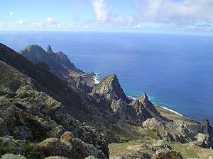
| View from Trindade to the Atlantic | ||
| Waters | Atlantic Ocean | |
| Archipelago | Trindade and Martim Vaz | |
| Geographical location | 20 ° 30 ′ 30 ″ S , 29 ° 19 ′ 34 ″ W | |
|
|
||
| length | 6 km | |
| width | 3 km | |
| surface | 10.3 km² | |
| Highest elevation | Pico Desejado 620 m |
|
| Residents | uninhabited | |
| Historical map of the island | ||
Trindade (Port. Ilha da Trindade , dt. "Island of the Trinity") is a Brazilian volcanic island in the Atlantic Ocean about 1150 kilometers east of Vitória .
Geography and geology
The approximately 6 km long and 3 km wide island has an area of around 10 km² and is by far the largest island in the Trindade and Martim Vaz archipelago . The island is an active stratovolcano with craters and numerous lava domes . It consists of rugged terrain that was forested until the 19th century; today it is barren with the exception of the southern part. Trindade is uninhabited except for the Brazilian naval post Enseada dos Portugueses .
history
The island was discovered in 1502 by the Portuguese navigator Vasco da Gama and was Portuguese territory until the independence of Brazil. Trindade was occupied by Great Britain from 1890 to 1896 until it was returned to Brazil by treaty.
Web links
- Trindade in the Global Volcanism Program of the Smithsonian Institution (English)


