Unzen Amakusa National Park
| Unzen Amakusa National Park | ||
|---|---|---|
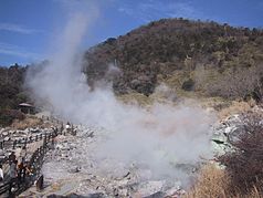
| The ounce jigoku (ounce "hell") | ||
|
|
||
| Location: | Nagasaki , Kumamoto , Kagoshima , Japan | |
| Surface: | 282.79 km² | |
| Founding: | March 16, 1934 | |
The Unzen Amakusa National Park ( Japanese 雲仙 天 草 国立 公園 , Unzen Amakusa Kokuritsu Kōen ) is located in the Kyūshū region . The park was established in 1934 as one of the first national parks in Japan. It was initially named after the Unzen volcanic complex as the Unzen National Park. In 1956, however, the park area was expanded to include the neighboring Amakusa region . The national park extends over the three prefectures of Nagasaki , Kumamoto and Kagoshima . The Japanese Ministry of Environment is responsible for the management of the national park.
landscape
Due to the volcanic activity around the Unzen, there are many hot springs ( onsen ) in the area . The Amakusa area in the south of the national park, on the other hand, is an archipelago comprising 120 islands with a rugged coastline.
Flora and fauna
The area of the Unzen Amakusa National Park is divided into three vegetation zones:
- deciduous deciduous forest above approx. 950 m altitude
- Mixed forest between approx. 600 and 950 m altitude
- evergreen deciduous forest below approx. 600 m altitude
gallery
Japanese flycatcher ( Cyanoptila cyanomelana )


