Valgjärve
| Valgjärve | |||
|
|||
| State : |
|
||
| Circle : |
|
||
| Coordinates : | 58 ° 5 ' N , 26 ° 39' E | ||
| Area : | 143.1 km² | ||
| Residents : | 1,556 (01.2005) | ||
| Population density : | 11 inhabitants per km² | ||
| Time zone : | EET (UTC + 2) | ||
| Community type: | former rural community | ||
| Website : | |||

|
|||
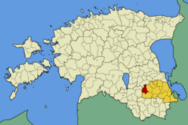
Valgjärve (Eng. Weißensee ) is a former rural community in the Estonian Põlva district with an area of 143.1 km². Saverna has been documented since 1582. It had 1,556 inhabitants (as of January 10, 2005). Valgjärve has been part of the rural municipality of Kanepi since 2017 .
geography
In addition to the main town of Saverna , the municipality also included the villages of Abissaare , Aiaste , Hauka , Kooli , Krüüdneri , Maaritsa , Mügra , Pikajärve , Pikareinu , Puugi , Sirvaste , Sulaoja , Tiido , Valgjärve and Vissi .
Attractions
The manor house in Saverna was one of the first to be sold to Estonian families by Baltic Germans . Particularly worth seeing in the municipality are the park and the lake (79.7 ha) of Valgjärve (translated: Weissensee , first mentioned in 1533 as Wytten see ).
The 347-meter-high Valgjärve transmission tower , the second-tallest structure in Estonia, is located on the territory of the former municipality .
Web links
- Valgjärve Municipality website (Estonian)

