Vasalemma (municipality)
| Vasalemma | |||
|
|||
| State : |
|
||
| Circle : |
|
||
| Coordinates : | 59 ° 15 ′ N , 24 ° 17 ′ E | ||
| Area : | 38.66 km² | ||
| Residents : | 5,005 (01.2010) | ||
| Population density : | 129 inhabitants per km² | ||
| Time zone : | EET (UTC + 2) | ||
| Community type: | former rural community | ||
| Website : | |||

|
|||
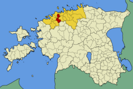
Vasalemma (German: Wassalem ) is a former rural community in the Estonian district of Harju with an area of 38.66 km². It had 5005 inhabitants (as of January 1, 2010). Vasalemma has been part of the newly formed rural community of Lääne-Harju since 2017 .
Vasalemma is located in the southwest of the district, approx. 38 km from Tallinn and is traversed by the Vasalemma river of the same name (length: 50 km).
structure
In addition to the main town Vasalemma, the municipality also included the villages of Ämari, Lemmaru, Rummu and Veskiküla.
Web links
- Website of the municipality of Vasalemma (Estonian)


