Victoria Falls National Park
|
Victoria Falls National Park
|
||
|
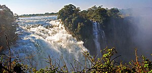
View of the Victoria Falls |
||
| location | Zimbabwe | |
| surface | 23.4 km² | |
| WDPA ID | 1993 | |
| Geographical location | 17 ° 55 ′ S , 25 ° 40 ′ E | |
|
|
||
| Setup date | 1952 | |
| administration | Zimbabwe Parks and Wildlife Management Authority | |
The Victoria Falls National Park (English: Victoria Falls National Park ) is a National Park in the west of Zimbabwe , right on the Zambezi -flow, the border with Zambia represents. The national park, which is open to tourism all year round, is 23 km² in size. In this small park there is a path that runs along the canyon of the Zambezi. On the Zimbabwean side you will find yourself opposite the Victoria Falls, which are particularly impressive in the rainy season with their width and mass of water. At various vantage points, visitors can see the falls and the resulting rainbows. Due to the permanent splashing water, a flora corresponding to the rainforest has developed directly opposite the falls, through which the hiking trail leads. The border crossing to Zambia is right next to the park. One of the most spectacular bungee jump stations in Africa is located here, directly in the canyon and the start of many rafting offers in the Zambezi. In the dry season in Victoria National Park on the Zambian side it is possible to bathe in a small pool directly in the falls if you can find a local guide.
Victoria Falls is a small, very modern place for Zimbabwean standards, which is the only one in Zimbabwe that is completely geared towards tourism. The reason for this is the large number of tour groups that stop in this border region between Zambia, Zimbabwe and Botswana.
Web links
- Zimbabwe Parks & Wildlife Management Authority: Victoria Falls National Park Overview . on www.zimparks.org (English)

