Vila Garcia (Amarante)
| Vila Garcia | ||||||
|---|---|---|---|---|---|---|
|
||||||
| Basic data | ||||||
| Coordinates : | 41 ° 19 ′ N , 8 ° 5 ′ W | |||||
| Postal code : | 4600-810 | |||||
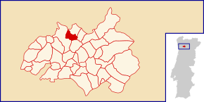
Vila Garcia is a place and a former municipality in northwest Portugal .
history
The manor and estate Solar de Vila Garcia has existed since at least the 16th century . Today it is a listed building, as is the parish church Igreja Paroquial de Vila Garcia from the 18th century. In the registers from 1758, Vila Garcia is listed as an independent parish for a long time.
In the course of the territorial reform in 2013 , the municipality of Vila Garcia was dissolved and merged with Chapa and Aboim to form a new municipality.
administration
Vila Garcia was the seat of an independent municipality ( freguesia ) in the district ( concelho ) of Amarante in the district of Porto . The community had an area of 3.6 km² and 803 inhabitants (as of June 30, 2011).
With the administrative reorganization in Portugal on September 29, 2013, the municipalities of Vila Garcia, Chapa and Aboim were merged to form the new municipality of União das Freguesias de Vila Garcia, Aboim e Chapa . Since then, Vila Garcia has been the seat of this newly formed municipality.
sons and daughters of the town
- António Pinto (* 1966), Olympic athlete
Web links
- Map of the Freguesia Vila Garcia at the Instituto Geográfico do Exército
- Information about Vila Garcia. amarante.pt, accessed June 12, 2011 (Portuguese).
Individual evidence
- ^ Entry of the Solar de Vila Garcia in the Portuguese list of monuments SIPA, accessed on October 31, 2015
- ^ Entry of the Solar de Vila Garcia in the Portuguese list of monuments SIPA, accessed on October 31, 2015
- ↑ a b Publication of the administrative reorganization in the Diário da República gazette of January 28, 2013, accessed on October 1, 2014


