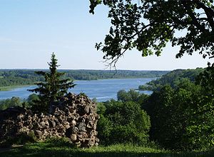
Viljandi lake
| Viljandi lake | ||
|---|---|---|

|
||
| View of the Viljandi lake | ||
| Geographical location | Viljandi , Estonia | |
| Drain | Raudna | |
| Places on the shore | Viljandi | |
| Data | ||
| Coordinates | 58 ° 21 '23 " N , 25 ° 36' 8" E | |
|
|
||
| Altitude above sea level | 42.35 m | |
| surface | 1.58 km² | |
| length | 4.33 km | |
| width | 435 m | |
| Maximum depth | 11 m | |
The Viljandi Lake (Estonian: Viljandi järv ) is a lake near the Estonian city of Viljandi in the district of the same name .
Its length is 4.33 km. It covers an area of 158 hectares. At its widest point it is 435 m wide.
The Viljandi lake is a typical valley lake: long, with a high bank and relatively deep. The greatest depth is 11 m. The outflow of the lake is formed by the Raudna river , which flows into the Riga Bay via the Navesti and Pärnu rivers .
Web links
- Full description (Estonian)
