Wager Bay
| Wager Bay | ||
|---|---|---|
|
Wager Bay with Sila River |
||
| Waters | Hudson Bay | |
| Geographical location | 65 ° 31 ′ N , 88 ° 52 ′ W | |
|
|
||
| width | 30 km | |
| length | 150 km | |
| Greatest water depth | 133 m | |
| Islands | Savage Islands, Paliak Islands | |
| Tributaries | Brown River , Piksimanik River | |
|
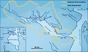
Map of Wager Bay in Ukkusiksalik National Park |
||
Wager Bay is a bay in the northwest of Hudson Bay in Ukkusiksalik National Park .
It reaches a maximum extension of 150 km in the north-west direction. Their width varies between 3 km at the entrance to the bay, the Narrows, and up to 30 km in the central area. Access to the bay is flanked by Cape Dobbs and Cape Montague. At the end of the bay are the Reversing Falls . Behind it is Ford Lake , into which the Brown River flows. The bay is framed by steep cliffs that reach heights of up to 290 m in the southwest. To the east the bay opens to the Roes Welcome Sound .
The book was named in 1742 by the English navigator and member of the Royal Society Christopher Middleton . He was the first European to penetrate the fjord with his Bombarde Furnace and was then held there by drift ice for three weeks. He named the bay after the then reigning First Lord of the British Admiralty , Sir Charles Wager .
Individual evidence
- ↑ a b Marine World Database ( page no longer available , search in web archives ) Info: The link was automatically marked as defective. Please check the link according to the instructions and then remove this notice.


