
Wall moraine near Buflingsried

The wall moraine near Buflingsried is a geotope east of Scheidegg in the Lindau district (Lake Constance) . Ice-age sediments in the Rhine Young Moraine region south of the German Alpine Road form an up to 20 m high Young Pistocene double moraine wall on the Roderbühl over a length of 600 meters .
geology

The distinctive elevation of the Roderbühl (849 m above sea level) was formed in the Upper Pleistocene during the retreat of a lobe of the Rhine glacier . The terminal moraine on the Roderbühl, designed as a double moraine wall, is one of the terminal moraine series that were deposited on the edge of the glacier in the late high glacial of the Würm glacial period in the northern foothills of the Alps during the oscillating advance and retreat of the Rotach tongue of the Rhine glacier. Today the terminal moraines, together with dead ice holes , Osers and Kames, form the morphologically strongly structured ice break-up landscapes in the Lindau district.
The geotope wall moraine near Buflingsried has been classified by the Bavarian State Office for the Environment as a geoscientifically significant geotope (geotope no. 776R004) with a suitability as a geotouristic object.
Todays situation
The terminal moraine is now in the area of a golf course . When it was built, the original shape of the site was greatly changed in some areas.
A flight observation bunker was built on the Roderbühl in 1936 , remains of which are still present today.
The wall moraine of Buflingsried is one of the stops on Tour 5 of the Westallgäu waterways hiking trail system . Corresponding information boards on geology and landscape development have been set up on the ridge.

View of the terminal moraine wall
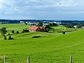
Golf course in the terminal moraine landscape

Roderbühl aerial observation bunker
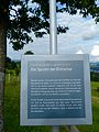
Information board "Westallgäu waterways"
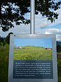
Information board "Westallgäu waterways"


See also
Individual evidence
- ^ Ulrich Lagally, Stefan Glaser, Elisabeth Jobe, Georg Loth, Andreas Murr, Hubert Schmid, Wolfgang Schmid, Klaus Schwerd, Stephan Sieblitz and Ulrich Teipel: Geotope in Schwaben . In: Bavarian State Office for the Environment (Ed.): Earth science contributions to nature conservation . tape 7 . Augsburg 2009, ISBN 978-3-936385-34-2 , pp. 121 .
- ^ Ulrich Lagally, Stefan Glaser, Elisabeth Jobe, Georg Loth, Andreas Murr, Hubert Schmid, Wolfgang Schmid, Klaus Schwerd, Stephan Sieblitz and Ulrich Teipel: Geotope in Schwaben . In: Bavarian State Office for the Environment (Ed.): Earth science contributions to nature conservation . tape 7 . Augsburg 2009, ISBN 978-3-936385-34-2 , pp. 128 .
- ↑ Geotope data sheet of the Bavarian State Office for the Environment: Geotope no. 776R004 Wall moraine near Buflingsried , accessed on August 9, 2016.
literature
- T. Vollmayr & JH Ziegler: Geological map of Bavaria 1: 25,000. Explanations to sheet no.8425 Weiler I. Allgäu , Bavarian Geological State Office (ed.), Munich 1976, 76 pp.
- M. Rappol & K. v. Gijssel: Sedimentary Petrography of Glacial Deposits in the Rotach Valley, Western Allgäu, Southern West Germany , Eiszeitalter und Gegenwart, 38, Hannover 1988, pp. 52-68.
Web links
- Wall moraine near Buflingsried , geotope data sheet from LFU Bavaria
- Allgäu waterways: Tour 5
Coordinates: 47 ° 35 ′ 0.4 ″ N , 9 ° 51 ′ 56 ″ E