Weißenstein (Steinwald)
| Weissenstein | ||
|---|---|---|
|
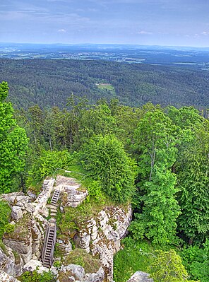
Weißenstein ruins view from the main tower |
||
| height | 863 m | |
| location | Bavaria , Germany | |
| Mountains | Fichtel Mountains | |
| Coordinates | 49 ° 54 '51 " N , 12 ° 4' 50" E | |
|
|
||
The Weißenstein is a 863 m high mountain peak in the Steinwald , the southern part of the Bavarian Fichtelgebirge in the Steinwald Nature Park .
topography
In the eastern, steeply sloping area of the Steinwaldkamm there is a bizarre granite rock landscape in which the remains of the walls of a former castle are located. The landowner is Baron von Gemmingen-Hornberg zu Friedenfels, in the Upper Palatinate district of Tirschenreuth. The name Weißensteinerkette for the entire south-east flank of the Fichtelgebirge was forgotten and is no longer used today.
Castle ruins
The keep stood on the highest rock, the ruins of which are now used as a lookout point. The name of the Steinwaldburg Weißenstein first appears in a document on March 21, 1279 as “Wisstenstein”. In 1309 Nothaft appeared for the first time as co-owners of the castle, whose descendants were then landowners until 1882. The castle served as a residence until around 1560, after which the buildings fell into disrepair. The company Steinwaldia Pullenreuth eV carried out the restoration of the remaining parts of the building in 1996/2000 with considerable expenditure of time and money, thus ensuring the preservation of the cultural and historical monument. In an information pavilion, the visitor receives information about the history of the Weißenstein and the renovation of the facilities.
literature
- Dietmar Herrmann, Helmut Süssmann: Fichtel Mountains, Bavarian Vogtland, Steinwald, Bayreuther Land. Lexicon . Ackermannverlag, Hof (Saale) 2000, ISBN 3-929364-18-2 .

