
Western Brook Pond
| Western Brook Pond | ||
|---|---|---|

|
||
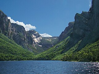
| The Western Brook Pond with the Pissing Mare Falls in the background | ||
| Geographical location | Newfoundland Island , Newfoundland and Labrador (Canada) | |
| Drain | Western Brook → Gulf of Saint Lawrence | |
| Location close to the shore | Rocky Harbor | |
| Data | ||
| Coordinates | 49 ° 46 ′ N , 57 ° 49 ′ W | |
|
||
| Altitude above sea level | 25 m | |
| surface | 23 km² | |
| length | 16 km | |
| width | 2 km | |
| Maximum depth | 165 m | |
| Catchment area | 170 km² | |
|
particularities |
The lake was created as a fjord |
|

The Western Brook Pond is a fjord in Gros Morne National Park in the west of the island of Newfoundland , which belongs to the Canadian province of Newfoundland and Labrador , whose connection with the sea was lost due to an uplift of the coast, so that it is now a lake. The distance from the sea is 2.5 km.
Geography and Origin
The Western Brook Pond is 16 km long and up to 165 m deep. The surrounding mountain range is up to 600 m high. The lake has a water surface of 23 km² and lies at a height of about 25 m . The catchment area of the lake covers around 170 km². The 10 km long Western Brook drains the lake to the nearby coast of the Gulf of Saint Lawrence . The Route 430 runs about 2.3 km west of the lake. From there a path leads to the western shore of the lake. The Pissing Mare Falls , the second highest waterfall in Canada and 199th highest waterfall on earth (see also list of known waterfalls ), is located on the eastern south shore of the lake.
The Western Brook Pond was formed by glaciers during the Cold Age around 25,000 to 10,000 years ago . After these melted, the fjord lost its connection to the open sea. Today the fjord is filled with one of the purest fresh waters on earth.
Flora and fauna
The fjord can be reached via a paved, three-kilometer-long wooden path that leads through a moor landscape . Here are among other carnivorous plants such as pitcher plant , sundew and butterwort to find.
Atlantic salmon , brook char , arctic smelt , American eel and three-spined and nine-spined sticklebacks occur in the runoff of the Western Brook Pond and in the lake itself . The mammals that are in the water in the region include the American mink , the North American otter , the Canadian beaver and the muskrat .
tourism
The Western Brook Pond can be visited by boat in the summer season (June to October). A local ship operator provides two boats for this purpose, one of which can transport a boat 70 and the other a maximum of 90 people.
On a boat tour, it is also possible to leave the boat at the end of the fjord and hike up the mountain.
Trivia
- After parts of the surrounding mountain range collapsed into the fjord, a 30 m high tsunami occurred at the beginning of the 20th century .
- The sightseeing boats in the fjord had to be flown in whole or in parts by helicopter into the fjord bay, as the area around is not accessible by land.
photos

Western Brook Pond as seen from the hiking trail
Eastern end of Western Brook Pond


literature
- Frommer's Newfoundland & Labrador, p. 176, ISBN 0-470-83223-1
Individual evidence
- ↑ Gros Morne National Park - Trail Guide
- ↑ a b Water Quality Station Profile, Station #: NF02YE0005, WESTERN BROOK AT ROUTE 430 . Environment and Conservation, Government of Newfoundland and Labrador - Canada. Retrieved December 10, 2018.
- ↑ NASCO Rivers Database Report (PDF, 1.4 MB) North Atlantic Salmon Conservation Organization (NASCO). Retrieved November 22, 2018.
- ↑ Alan Ruffman, P. Geo: Atlantic tsunamis: "Like a River Returning" . Maritime Museum of the Atlantic. Archived from the original on November 18, 2008. Info: The archive link was inserted automatically and has not yet been checked. Please check the original and archive link according to the instructions and then remove this notice. Retrieved March 14, 2010.