Gros Morne National Park
| Gros Morne National Park | ||
|---|---|---|
| Western Brook Pond | ||
|
|
||
| Location: | Newfoundland and Labrador , Canada | |
| Next city: | Deer Lake | |
| Surface: | 1805 km² | |
| Founding: | 1973 | |
| Visitors: | 244,292 (2016/2017) | |
| Address: |
Gros Morne National Park P.O. Box 130 Rocky Harbor, NL Tel. (709) 458-2417 |
|
| Gros Morne National Park | ||
| Red rocks in the tablelands | ||
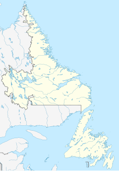
The 1,805 square kilometer Gros Morne National Park ( English Gros Morne National Park of Canada , French Parc national du Canada du Gros-Morne ) is located on the west coast of Newfoundland . It is the second largest park in Atlantic Canada after the Torngat Mountains National Park . In 1987 the park was declared a World Heritage Site by UNESCO . The park is an IUCN Category II ( National Park ) protected area .
The name of the park is derived from Newfoundland's second highest mountain ( Gros Morne Mountain ), whose name means something like "large, solitary mountain" and which reaches a height of 807 m .
geography
The park is located in the Long Range Mountains , a branch of the Appalachian Mountains . It is located on the western side of Newfoundland. The landscape is formed by fjords , bays, lakes, plateaus and mountain valleys.
In the park there is the Pissing Mare Falls , which plunge 350 m into the Western Brook Pond and are the highest waterfalls in the east of the North American continent.
Other lakes in the national park include Ten Mile Pond , Bakers Brook Pond , Trout River Big Pond, and Trout River Small Pond .
geology
One of the special features of the landscape is the Western Brook Pond, a pristine fjord that was formed during the last ice age , lost its connection to the open sea after the ice masses melted and is now filled with one of the purest fresh waters on earth. This and other fjords, the mountain ridges carved by glaciers and the hanging valleys illustrate findings from glaciology and geomorphology .
In the park there are also the geologically valuable tablelands , a desert-like , barren landscape, characterized by the peridotite rock , which is reddish due to its oxidized iron content and originates in the earth's mantle . Only in very few places on earth material of the mantle over a large area on the earth's surface as here open-minded . The tablelands are therefore of great importance for research in the field of plate tectonics and were the main reason why the national park was declared a UNESCO World Heritage Site.
Another scenic highlight are the Green Gardens , which connect directly to the Tablelands in the national park. However, while the tablelands stand out due to their extremely barren landscape, the green gardens show a strikingly intense plant growth.
Finds of sedimentary rocks in the park indicate an oceanic past. These rock layers were sea floors 540–440 million years ago, ie in the Cambrian and Ordovician .
Flora and fauna
Lynx , black bears , reindeer , moose , foxes and bald eagles are native to the park . Whales can be seen off the coast . Carnivorous plants such as Pitcher plants , butterworts and sundew are Flora of the National Park.
photos
Coast of the Gulf of Saint Lawrence
Web links
- Gros Morne National Park , on Parks Canada , (English, French)
- Entry on the UNESCO World Heritage Center website ( English and French ).
- Gros Morne National Park ( English, French ) In: The Canadian Encyclopedia .
Individual evidence
- ↑ World Database on Protected Areas - Gros Morne National Park of Canada (English)
- ^ Gros Morne in the Internet version of the Canadian Mountain Encyclopedia
- ↑ From the Intertidal Zone to the Upper Mantle - The Amazing Geology of Gros Morne National Park, Fall Field Trip 2003. (PDF; 11.2 MB) Geological Association of Canada. Newfoundland Section, accessed September 8, 2019 .


