Kouchibouguac National Park
| Kouchibouguac National Park | ||
|---|---|---|
|
|
||
| Location: | New Brunswick , Canada | |
| Surface: | 239 km² | |
| Founding: | 1969 | |
| Visitors: | 169,262 (2016/2017) | |
The Kouchibouguac National Park ( English Kouchibouguac National Park of Canada , French Parc national du Canada Kouchibouguac ) is a Canadian national park in New Brunswick (Eastern Canada ) north of Richibucto . The park is an IUCN Category II ( National Park ) protected area managed by Parks Canada , a Crown Agency (federal agency). The area was also designated in full as a Dark Sky Preserve in 2009 ( light protection area , Kouchibouguac Dark Sky Preserve ).
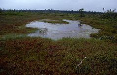
It has an area of 238 km² and was founded in 1969 . The park consists of sandbanks , dunes (length: 25 km), lagoons , salt marshes and forests. It provides a habitat for sea birds , e.g. B. the endangered yellow-footed plover . Here is the second largest population of terns in North America. In the wetlands of the national park, among others, a. Pitcher plants . Butterflies such as Limenitis archippus (Viceroy Butterfly) can also be observed here.
The name is derived from the name for the Kouchibouguac River that flows through the park, in the language of the Mi'kmaq , an Indian people living in eastern North America . Other rivers in the park are Black River and Saint-Louis River.
Web links
- Kouchibouguac National Park , on Parks Canada , (Eng., Fr.)
Individual evidence
- ↑ World Database on Protected Areas - Kouchibouguac National Park (English)
- ^ Royal Astronomical Society of Canada: Dark-Sky Site Designations (with map).


