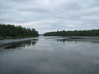
Kouchibouguac River
| Kouchibouguac River | ||
|
Kouchibouguac River in Kouchibouguac National Park |
||
| Data | ||
| location | New Brunswick ( Canada ) | |
| River system | Kouchibouguac River | |
| Headwaters | Wetland 45 km south of Miramichi 46 ° 36 ′ 43 ″ N , 65 ° 29 ′ 28 ″ W |
|
| Source height | approx. 100 m | |
| muzzle | Kouchibouguac Bay ( Gulf of Saint Lawrence ) Coordinates: 46 ° 50 ′ 3 " N , 64 ° 55 ′ 45" W 46 ° 50 ′ 3 " N , 64 ° 55 ′ 45" W |
|
| Mouth height | 0 m | |
| Height difference | approx. 100 m | |
| Bottom slope | approx. 1.6 ‰ | |
| length | 64 km | |
| Catchment area | approx. 360 km² | |
| Discharge at the gauge near Vautour A Eo : 177 km² Location: 32 km above the mouth |
MQ 1970/1994 Mq 1970/1994 |
3.8 m³ / s 21.5 l / (s km²) |
The Kouchibouguac River is a 40 miles long river in the Canadian province of New Brunswick .
River course
The Kouchibouguac River runs in northern Kent County . Its headwaters form a 100 m high wetland, about 45 km south of Miramichi . It flows in an east-northeast direction to the sea. The last 10 kilometers of the river are within the Kouchibouguac National Park . The river finally flows into Kouchibouguac Bay , an estuary that is separated from the open sea by a spit . The Kouchibouguacis River runs further south .
Hydrology
The Kouchibouguac River drains an area of around 360 km². The mean discharge at the gauge 32 km above the mouth is 3.8 m³ / s. In April and May the river usually carries the largest amount of water with an average of 12.8 and 8.8 m³ / s.
Web links
- Kouchibouguac River at Natural Resources Canada
