Rouge National Urban Park
| Rouge National Urban Park | ||
|---|---|---|
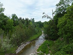
| The Little Rouge Creek | ||
|
|
||
| Location: | Ontario , Canada | |
| Next city: | Toronto | |
| Surface: | 62.9 km² | |
| Founding: | 2015 | |
| Address: |
Rouge National Urban Park 1749 Meadowvale Rd Scarborough, ON |
|
The Rouge National Urban Park ( English ; French Parc urbain national de la Rouge ) is a Canadian national park in the province of Ontario . The park stretches in Toronto's eastern district of Scarborough along the Rouge River , while other parts of the park are in the area of the cities of Markham and Pickering . The park area covers an area of 62.9 km². The park is said to be 79.1 km² one day and is partially adjacent to the Toronto Zoo . It is the first National Urban Park in Canada, completely enclosed by urban area and is passed by the Ontario Highway 401 .
The park is an IUCN Category V ( Protected Landscape / Protected Marine Area ) protected area .
The national park emerged from the Rouge Park founded in 1985 . This approximately 40 km² park was already a cross-city amalgamation of areas in the three cities of Toronto, Markham and Pickering.
Web links
- Rouge National Urban Park , on Parks Canada , (English, French)


