
Long Range Mountains
| Long Range Mountains | ||
|---|---|---|
 The Cabox , the highest point in the mountain range |
||
| Highest peak | The Cabox ( 814 m ) | |
| location | in the west of the island of Newfoundland in the province of Newfoundland and Labrador ( Canada ) | |
|
||
| Coordinates | 50 ° 25 ′ N , 57 ° 10 ′ W | |

The Long Range Mountains are about 450 km long mountain range on the west coast of Newfoundland , which geologically - in the context of the Caledonian mountain formation - forms the northern continuation of the Appalachians and extends from Port aux Basques to St. Anthony .
The Long Range Mountains were formed in the Precambrian by plate tectonics . The supercontinent Rodinia broke up 570 million years ago and the Iapetus Ocean was formed . In Gros Morne National Park is part of the Long Range Mountains, is the oldest rock Newfoundland from the west coast of this ocean. Numerous fjords such as the Western Brook Pond or the Ten Mile Pond , both of which have no connection to the sea, were created after the supercontinent broke up.
The Long Range Mountains consist of the Anguille Mountains , the Lewis Hills and the Tablelands , to which the Gros Morne National Park owes its inclusion in the list of UNESCO World Heritage . The highest peaks are The Cabox west of Corner Brook with 814 m , Gros Morne in the national park of the same name with 807 m and Blue Mountain with 800 m . The average altitude is 670 m . The mountains rise steeply and craggy from the sea, form flat peaks and plateaus and run flat to the east towards the Newfoundland inland.
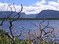
The Western Brook Pond, a fjord in Gros Morne National Park

Fjord on the west side of the Long Range Mountains

The Long Range Mountains in Gros Morne National Park


Web links
- Long Range Mountains ( English, French ) In: The Canadian Encyclopedia .