
Wicklow Way
| Wicklow Way Slí Cualann Nua |
|
|---|---|
 The JB Malone memorial on Wicklow Way looking over Lough Tay |
|
| Data | |
| length | 132 km |
| location | Eastern Ireland |
| Markers |

|
| Starting point | Marlay Park, Dublin 53 ° 16 ′ 38.7 ″ N , 6 ° 16 ′ 6.3 ″ W. |
| Target point |
Clonegal 52 ° 41 ′ 43.2 " N , 6 ° 38 ′ 54.3" W. |
| Type | Long-distance hiking trail |
| The highest point | White Hill (630 m) |
| Lowest point | Clonegal (60 m) |
| Level of difficulty | demanding |
| season | all year round |
| particularities | Wicklow Mountains , Glendalough |
The Wicklow Way ( Irish Slí Cualann Nua ) is a 132 km long long- distance hiking trail in Ireland that connects the cities of Dublin and Clonegal .
description
The northern section in the Wicklow Mountains extends from Dublin to Aughavannagh and is characterized by large and flattened peaks with a series of deep valleys and a mixture of deciduous and coniferous forests, as well as heather and flat bogs. The Wicklow Mountains run gently in the southern part of the route and offer shelter for many animals in numerous hedges. The Wicklow Way follows forest trails, mountain paths and quiet country lanes and also passes through the monastic settlement of Glendalough , which was founded in the 6th century by Kevin of Glendalough .
Stages
The following is an exemplary route distribution:
| Starting point | End point | route | Height difference | Walking time | |
|---|---|---|---|---|---|
| Stage 1 | Marlay Park, Dublin | Glencullen | 10 km | ± 430 m | 3.5 h |
| Stage 2 | Glencullen | Glencree | 12 km | ± 290 m | 3.5 h |
| Stage 3 | Glencree | Lough Tay | 12 km | ± 450 m | 4 h |
| Stage 4 | Lough Tay | Oldbridge | 6 km | ± 90 m | 1.5 h |
| Stage 5 | Oldbridge | Glendalough | 10 km | ± 350 m | 3.5 h |
| Stage 6 | Glendalough | Glenmalure | 13 km | ± 460 m | 4.5 h |
| Stage 7 | Glenmalure | Aughavannagh | 12 km | ± 390 m | 4 h |
| Stage 8 | Aughavannagh | Moyne | 10 km | ± 230 m | 3 h |
| Stage 9 | Moyne | Tinahely | 11 km | ± 250 m | 3 h |
| Stage 10 | Tinahely | Boley | 12 km | ± 270 m | 3 h |
| Stage 11 | Boley | Clonegal | 20 km | ± 380 m | 6 h |
The Wicklow Way can easily be done in five to seven days by combining several stages.
Impressions

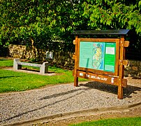
Starting point in Marlay Park, Dublin
End point in Clonegal

The Wicklow Way near Curtlestown
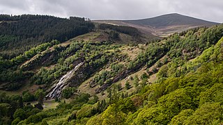
Powerscourt Deerpark and Powerscourt Waterfall with Djouce Mountain in the background

On White Hill

Monastery settlement in Glendalough

Glendalough view


