Wicklow Mountains
| Wicklow Mountains Sléibhte Chill Mhantáin |
||
|---|---|---|
|
Wicklow Mountains |
||
| Highest peak | Lugnaquilla ( 925 m ASL ) | |
| location | County Wicklow , County Wexford ( Ireland ) | |
|
|
||
| Coordinates | 53 ° 5 ′ N , 6 ° 20 ′ W | |
| rock | Sandstone | |
The Wicklow Mountains ( Irish Sléibhte Chill Mhantáin ) are a mountain range in the east and south-east of Ireland . They run in a north-south direction, directly from the south of Dublin via County Wicklow into County Wexford .
Geology and flora
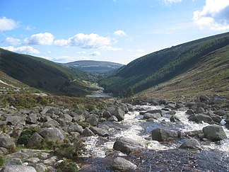
The Wicklow Mountains are mainly made up of granite and slate that were folded during the Caledonian orogeny phase. The mountains, rounded by Ice Age glaciers, are largely covered by (mostly blanket) moors .
A diverse flora has developed under these conditions . In the valleys and lower slopes this consists mainly of king fern , gorse , and heather , grasses such as z. B. Sedges and wild blueberries . The heather in particular contribute to a typical image of the Wicklow Mountains during the flowering period in summer, in which they cover entire mountain slopes in purple.
Forests are the exception in the Wicklow Mountains, as they were cut down by humans at an early age. The extensive deforestation of the forests was also the cause of the widespread use of the moors. Nowadays, however, more extensive reforestation is taking place. However, it is no longer the original oak and birch forests , but fast-growing spruce species whose wood can be used for the timber industry within a few years. In some places, however, afforestation has been taking place again in the past few years in the sense of restoring the original deciduous forests, e.g. B. in the northern slopes of the Derrybawn Mountains above the Lower Lakes of Glendalough .
mountains
The Wicklow Mountains, like all Irish mountains, are not particularly high. The highest mountain is the Lugnaquilla ( Log na Coille ) with 925 m, followed by Mullaghcleevaun ( Mullach Cliabháin ) with 849 m and Tonelagee ( Tóin le Gaoith ) with 817 m.
Other mountains (according to height):
- Corrigasleggaun ( Carraig na Sliogán ) 794 m
- Slievemaan ( Sliabh Meáin ) 759 m
- Camenabologue ( Céim na mBulóg ) 758 m
- Kippure ( Cipiúr ) 757 m
- Conavalla ( Ceann an Bhealaigh ) 734 m
- Djouce ( Dioghais ) 725 m
- Sea fingering ( Suí Fionnagáin ) 723 m
Due to the moorland landscape, most of the mountains in the Wicklow Mountains have a rounded plateau-like peak. Due to severe soil erosion , these are often covered with furrows as high as a man (so-called peat hags ). In particular, through popular mountain hiking, stronger erosion paths have already emerged. B. on Mount Djouce . On the part of various organizations, above all the Wicklow Mountains National Park , frequently used hiking trails (such as parts of the Spink in Glendalough) are laid out with floor planks (so-called boardwalks ) in order to avoid aggravated erosion by humans.
Rivers, Lakes and Use of Water
The River Slaney has its source in the southwest of the Lugnaquilla Mountain and flows 117 km south along the western foothills of the mountains before flowing into the Irish Sea at Wexford via the St. George's Canal . The River Liffey , widely known as a significant part of the cityscape of Dublin , has its source east of Kippure and southeast of Sally Gap ( Bearna Bhealach Sailearnáin ). Numerous lakes, so-called loughs, also characterize the landscape. The important ones include Lough Tay (also called Luggala Lake, Irish Loch Té ), Lough Dan ( Loch Deán ), Lough Bray ( Loch Bré ), Lough Ouler ( Loch Iolar ), Lough Nahanagan ( Loch na hOnchon ) and the Upper Lake ( At Loch Uachtair ) and Lower Lake ( Loch na Péiste ) in Glendalough .
There are several waterfalls in the Wicklow Mountains. The largest and most famous waterfall is the Powerscourt waterfall ( Eas Chúirt an Phaoraigh ), which is also the highest waterfall in Ireland. Another larger waterfall is in Glenmacnass just off Military Road east of Mount Scarr ( Scor ). Poulanass Waterfall ( Poll an Easa ) in Glendalough is another well-known waterfall in the Wicklow Mountains.
The Turlough Hill Power Plant is the only pumped storage power plant project in Ireland. It is located on top of Turlough Hill ( Cnoc an Turlaigh ), just off Old Military Road and very close to Wicklow Gap ( Bearna Chill Mhantáin ).
In Roundwood on the eastern foothills of the mountain range is the Vartry Reservoir Lakes, fed by the Vartry River ( Abhainn Fheartraí ), which represent the drinking water supply for Dublin . On the other side at the western foot is the Blessington Lakes, which also serve as a reservoir for Dublin's drinking water supply.
Recreation area
The entire area is visited by numerous Dubliners and foreign tourists, especially on the weekends, as the region offers many forms of relaxation, such as B. fishing or rafting . However, the most popular is mountain hiking. The Lug Walk takes place annually, named after the Lugnaquilla mountain (see above): The 50 km long march usually leads through marshy or very uneven terrain and over 18 peaks.
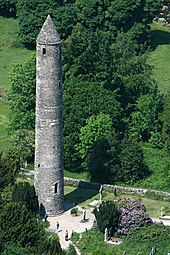
In the middle of the mountain range is Glendalough , which, according to legend, was founded by Saint Kevin and has, among other things, the ruins of six monastery churches. Glendalough claims to be "the spiritual center of Ireland".
Attractions
In the heart of the Wicklow Mountains is Wicklow Mountain National Park with a visitor center at Glendalough , where visitors can learn about the landscape, native flora and fauna and the diverse, well-marked hiking trails. The parking lot and visitor center are located in a valley on Lower Lake, which is connected to Upper Lake. There are several hiking trails around the two lakes with different levels of difficulty and length (longest route: 11 km; 580 meters in altitude). With suitable footwear and, if necessary, rainwear, the majority of the hiking trails are no problem even for inexperienced holiday hikers.
From numerous vantage points one has a view of the valley in which the visitor center and the Lower and Upper Lake are located, and from some points of the entire area of the Wicklow Mountains. The national park impresses with its vegetation, but not least because of the old monastery village Glendalough in the middle .
The Powerscourt Gardens are located on the northern foothills of the Wicklow Mountains at the foot of the 503 m high Sugar Loaf Mountain near the village of Enniskerry just under 20 km south of Dublin ; they are considered to be one of the most beautiful of their kind in Ireland and cover around 190,000 m².
Russborough House is an 18th century mansion. The building, now open to the public, was built by Richard Cassels in the Palladian style for the first Earl of Milltown. Today's interior furnishings and the art collection presented there are mainly from the last residents, Sir Alfred Lane Beit and Lady Clementine Beit.
The Wicklow Gold or Irish Gold Rush of 1795
1795 a schoolmaster in the river was Aughatinavought (now Goldmines River , Abhainn an Mhianaigh OIR ) gold . That didn't stay a secret for long, and by autumn of the same year many of his neighbors were already pulling gold from the river. The largest site was the Red Hole , about a kilometer below the Ballinagore Bridge. Around 80 kg of gold are said to have been washed within six weeks. Including the Wicklow nugget, weighing around 682 grams, and the largest lump of gold ever found in the British Isles. A copy is in the Natural History Museum of London. The original was melted down. It is said that they had a snuffbox for George III. made from it.
On October 15, 1795, the British government took over the business, which was legalized by Parliament 18 months later. Up to 1800 over 300 kg of gold had been washed, but the yield continued to decline; In 1801 the mine was closed. Until 1803 they searched for the Urader, but could not find it.
The origin of Wicklow gold
Despite extensive excavations around 1800 by Thomas Weaver, the geologist of the gold mine, nothing was found. Its numerous search trenches - it is said to have been almost 13 kilometers - can still be seen today, according to reports, at Mount Croghan Kinsella ( Cruachán ).
Even today's attempts to track down the origin by means of isotope analysis have so far been unsuccessful. It is now known that the site is the bed of a much older river that flowed in today's area before the mountain formation. All other gold veins in the area therefore show a different isotope combination.
Nowadays the area is part of the Wicklow Mountains National Park . The brief gold rush inspired the Irish composer John O'Keefe to write the comic opera The Wicklow Montains .
See also
literature
- The hunt for the Wicklow Gold . In: New Scientist, No. 2588, p. 48ff.
- Redar / McArdke: The Wicklow Gold . In: Journal of the Mining Heritage trust of Ireland, No. 3, p. 15.
Web links

- Letter to the Royal Society about the Wicklow Gold
- Investigations into the origin of gold ( Memento from August 21, 2009 in the Internet Archive )
- Mines in Wicklow - Exhibition ( Memento from March 24, 2007 in the Internet Archive )
- Wicklow Mountains National Park
- www.visitwicklow.ie (Wicklow County Tourism)
Individual evidence
- ↑ Flora ( Memento from February 6, 2015 in the Internet Archive )
- ↑ The Wicklow gold nugget ( Memento from August 19, 2009 in the Internet Archive )
- ↑ http://www.encyclopedia.com/doc/1Y1-103651484.html ( page no longer available , search in web archives ) Info: The link was automatically marked as defective. Please check the link according to the instructions and then remove this notice.


