Wjalosero
| Wjalosero | ||
|---|---|---|

|
||
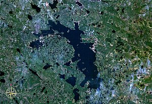
| Satellite image of the Wjalosero | ||
| Geographical location | Murmansk Oblast ( Russia ) | |
| Tributaries | Sen, Oderrutschei | |
| Drain | Wjala | |
| Data | ||
| Coordinates | 66 ° 50 ′ N , 35 ° 10 ′ E | |
|
|
||
| Altitude above sea level | 121 m | |
| surface | 98.6 km² | |
| length | 24 km | |
| width | 6 km | |
| Catchment area | 450 km² | |
The Wjalosero ( Russian Вялозеро ) is a lake in the southern part of the Kola Peninsula in the Russian Murmansk Oblast .
The lake has an area of 98.6 km² and is at an altitude of 121 m. The Wjalosero is ice-covered between late October, early November and late May. Larger tributaries are Sen ( Сень ) and Oderrutschei ( Одерручей ). The Wjalosero is drained by the Wjala , a tributary of the Umba .
Web links
Commons : Wjalosero - collection of images, videos and audio files
Individual evidence
- ↑ a b Vjalosero in the State Water Register of the Russian Federation (Russian)
- ↑ a b c Article Wjalosero in the Great Soviet Encyclopedia (BSE) , 3rd edition 1969–1978 (Russian)
