
Second Ellingen Roman camp
| Second Ellingen Roman camp | |
|---|---|
| limes | Rhaetian Limes |
| section | Route 14 |
| Construction | Earth fort |
| State of preservation | Ground monument, only visible in the aerial photo |
| place | Ellingen |
| Geographical location | 49 ° 3 '52.5 " N , 10 ° 58' 51.5" E |
| height | 440 m above sea level NHN |
| Previous | Theilenhofen Fort (west) |
| Subsequently | Ellingen Fort (east) |
The Second Ellingen Roman Camp is a former Roman military camp in the area of today's town of Ellingen in the Weißenburg-Gunzenhausen district in Bavaria .
In 1990 it was discovered during aerial photographs by aerial photo archaeologist Josef Mang from the Weissenburg gliding club. It is located around 500 meters as the crow flies west of the Ellingen Castle ( Castrum Sablonetum ).
During the construction of the road in the new “Am Rennfeld” development area in Ellingen, the camp's pointed trench was cut, thus ensuring its clear assignment as a Roman underground storage facility.
No further investigations have been carried out so far.
photos
The following images are from the information board at the site:
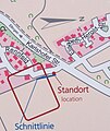
Location map

Aerial view
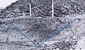
Section through the Spitzgraben


