
Almtal
| Almtal | ||
|---|---|---|
 Almtal near Grünau, view out of the valley |
||
| location | Traunviertel , Upper Austria | |
| Waters | Alm | |
| Mountains | Upper Austrian Pre-Alps or Salzkammergut Pre-Alps , Northern Alps | |
| Geographical location | 47 ° 57 ' N , 13 ° 59' E | |
|
||
| Type | Trough valley | |
| rock | Molasses , flysch , lime | |
| length | approx. 40 km | |
| use | inhabited; Tourist region | |

The Almtal is a valley in the Traunviertel in the Upper Austrian Alps through which the Alm flows. As the Lower Almtal , the valley area is one of the 41 Upper Austrian spatial units ; as the Almtal tourist region , it is part of the Salzkammergut .
Location and landscape
The valley is about 30 kilometers south of Wels in the Traunviertel . It stretches between the Trauntal (around the Traunsee ) in the west and Kremstal in the east for about 25 km in the Upper Austrian Pre-Alps (according to the Alpine Club division ) or the Salzkammergut Pre-Alps (according to the official regional division of the NALA ). The foothills are the Almtaler and Kirchdorfer Flysch Mountains . The mountains in the west are also called the (Eastern) Trauntal Alps , those in the east are called the Steyrtal Pre-Alps ( after Trimmel ).
The Taulung lies in the districts of Kirchdorf , Gmunden and Wels-Land .
The lowest Almtal around Vorchdorf and Bad Wimsbach-Neydharting already extends into the Traun-Enns-Riedelland of the Alpine foothills , where it is a typical depression with only a few dozen meters in relief. The core area around Pettenbach at the entrance to the valley, Scharnstein and into the valley Grünau im Almtal , which is still included in the landscape structure as part of the Lower Almtal, is a wide, friendly trough valley surrounded by the crests and cones of the foothills of the Alps. In the south, the valley extends into the Dead Mountains , which already belong to the Upper Austrian Limestone Alps . In the Hintertal lies the Almsee , the easternmost of the Salzkammergut lakes . At the end of the valley rises the Woising , in the east the Schermberg and the Große Priel .
The valley is not a through-going valley and has therefore retained its original character.
- Almtal

Almsee with Großem Woising
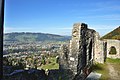
From the Scharnstein ruins via Scharnstein

At Grünau into the valley, view of the falcon wall

In the Hintertal am Grünaubach , view of the Geißstein

The Alm in Scharnstein
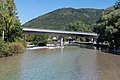
Bridge of the B120 in Scharnstein


Room unit Lower Almtal

The settlement area of the valley is referred to in the NALA landscape structure as the Lower Almtal (RA35). It stretches for around 35 km from north to south from the entry into the Lower Traun Valley at the end of the Traun Gorge to around 5 kilometers south of the Grünau widening. The width is a maximum of 2 km, usually the spatial unit is much narrower (up to 200 m). The zone also includes the lowest Laudach valley near Vorchdorf and the valley funnel of the Grünau stream near Grünau.
The area of the spatial unit is 46.6 km². The deepest area is around 375 m above sea level. A. at the north end of the room unit. The highest area of the area is near the Cumberland Wildlife Park in Grünau at around 550 m above sea level. A. All 5 Almtal communities have a significant share in the spatial unit.
The Lower Almtal cuts through the spatial units Salzkammergut-Voralpen , Almtaler and Kirchdorfer Flyschberge and Traun-Enns-Riedelland and thus forms a connection between the Alps and the Alpine foreland. The Almtal is also bordered by the following spatial units: Ager-Traun-Terrassen and Unteres Trauntal .
Natural characteristics:
- Sometimes wide and striking valley lowers of the Alm between Grünau and the Trauntal .
- The alluvial forest belt is not continuous. The ash predominates , pine , gray alder and spruce are less common .
- Individual forest areas outside the alluvial forest belt (e.g. Theuerwanger Forest near Vorchdorf) are mostly used as spruce forests. The border to the surrounding Riedelland is mostly natural forested. The embankments up to 60 meters high are also wooded and characterize this landscape. There are beech and ash- maple forests here. Giant horsetail areas are sporadic.
- Excellent water quality with grayling . Intensive use of the water by small power plants. There are hardly any standing waters.
- The lower terrace is poorly forested and is used for agriculture ( arable farming ). Increasing use of grassland upstream. Cultural landscape is rare because the area is characterized by settlement.
- Gravel pits are rather small and can be found occasionally on conglomerate partial walls. Extensive tuff springs can also be found.
- Unforested slopes still have a species - rich semi -arid grassland . Occasionally there are hot areas with a wealth of orchids and pipe grass lawns .
- The lower course is rural and sparsely populated. Upstream, from Vorchdorf, the area is increasingly densely populated and sprawled.
- The traffic routes shape the landscape.
- Precipitation decreases sharply to the north. The south is in the Nordstau .
Economy, transport and tourism
The L549 Almseestraße Mühldorf bei Scharnstein - Grünau leads through the Almtal . The Almtalbahn, which is connected to the western railway line in Wels, also ends in Grünau .
Almtal tourist region
The communities Grünau and Scharnstein form the actual Almtal ; The Almtal tourist association also includes the communities of Pettenbach , Vorchdorf and Bad Wimsbach-Neydharting on the lower reaches of the Alm and St. Konrad in the western connecting valley towards Gmunden, on the upper reaches of the Laudach.
The fact that the Almtal belongs to the Salzkammergut is a more recent development of the term as a tourism brand, it forms the eastern end here. As the Almtal holiday region , which is the Grünau tourist association, the Almtal has been included in the region since the 1950s and was also a founding member of the Salzkammergut Tourismus Destination Association . The multi-municipality tourism association (MTV) or tourism association Almtal has existed since January 1st, 2013 (first general assembly January 21st, 2013 in Vorchdorf) The concept of the MTV Almtal was developed by the association for the tourist, economic and rural development of the Almtal - association Almtal "Vera" ( VERA) with the participation of Upper Austria Tourism and Upper Austria Regional Management . The MTV Almtal is made up of the organizations Salzkammergut Tourismus-Marketing GmbH and the Almtal (Vera) association as well as the municipal tourism associations. The Kasberg Bergbahnen and the Cumberland Wildlife Park take part in tourism businesses .
The region has around 40,000 arrivals and just over 150,000 overnight stays per year. The average length of stay is 3.9 days; the Almtal is a typical destination for weekly guests. With 2 ⁄ 3 of the guests from Austria, the Almtal is, unlike the centers of the Salzkammergut, a domestic tourist destination.
The profile is based on gentle nature tourism, especially as a hiking and cycling region without intensive infrastructure, but personal hospitality ( enjoyment on the river project ). The main economic season is the summer season . The Kasberg is a small ski area, most of the area is an insider tip for ski tourers and winter hikers .
Attractions

The Almsee is a conservation area . In the neighboring valley of Grunau Bach lying Ödseen .
Attractions in addition to the natural beauty and the Austrian Crime Museum in Schloss Scharnstein and the sense Museum Geyerhammer in Scharnstein and Grünau in the Deer Park of Duke of Cumberland Foundation .
The Konrad Lorenz Research Center of the University of Vienna is located in Grünau .
- Worth seeing

Reintroduction project for the extinct bald ibises
Cumberland Wildlife Park

Narzissenwiese Bäckerschlagalm

Almsee in autumn


literature
- Office of the Upper Austrian Provincial Government, Nature Conservation Department (Ed.): Nature and Landscape / Guiding Principles for Upper Austria. Volume 39: Lower Almtal room unit . Linz 2007 ( pdf [accessed on February 18, 2017]).
Web links
- Das Almtal (almtal.at) - official website of the region (Vera Association)
- Almtal "VERA" association (almtalonline.at)
- Lower Almtal. In: Nature and Landscape in Upper Austria. Retrieved November 30, 2014 .
Individual evidence
- ↑ Ferienregion Almtal - official website of the Grünau im Almtal tourist association (on salzkammergut.at, until around May 2013)
-
↑ ORF-Online: optimism in the Almtal ;
Six towns became one region: the Almtal tourist office was founded . Edmund Brandner, OÖ Nachrichten , January 22, 2013 - ↑ ÖVP Bad Wimsbach Neydharting: MTV Almtal launched ( page no longer available , search in web archives ) Info: The link was automatically marked as defective. Please check the link according to the instructions and then remove this notice. , accessed on Feb. 6, 2013
- ↑ Almtal tourist office: announcement ; Retrieved Feb. 6, 2013
- ↑ Vorchdorf: KonradProcess “Overall Tourist Concept Almtal” (PDF; 2.8 MB); Retrieved Feb. 6, 2013
- ↑ a b c Tourismusverband Almtal: Arrivals and overnight stays , land-oberoesterreich.gv.at, accessed on 23 August 2018.
- ↑ The Almtal full of energy. “Enjoyment on the river” - start of the first major tourist project (PDF; 318 kB). Flyer for the press conference on April 16, 2013 (pdf, oberoesterreich-tourismus.at).