
Doemitz
| coat of arms | Germany map | |
|---|---|---|

|
Coordinates: 53 ° 8 ' N , 11 ° 16' E |
|
| Basic data | ||
| State : | Mecklenburg-Western Pomerania | |
| County : | Ludwigslust-Parchim | |
| Office : | Dömitz-Malliss | |
| Height : | 15 m above sea level NHN | |
| Area : | 60.43 km 2 | |
| Residents: | 3011 (Dec. 31, 2019) | |
| Population density : | 50 inhabitants per km 2 | |
| Postal code : | 19303 | |
| Area code : | 038758 | |
| License plate : | LUP, HGN, LBZ, LWL, PCH, STB | |
| Community key : | 13 0 76 034 | |
| LOCODE : | DE DTZ | |
| City structure: | 6 districts | |
City administration address : |
Rathausplatz 1 19303 Dömitz |
|
| Website : | ||
| Mayor : | Reinhold Suhrau | |
| Location of the city of Dömitz in the Ludwigslust-Parchim district | ||
  |
||

Dömitz ( Low German : Döms ) is a country town in the district Ludwigslust-Parchim the country Mecklenburg-Vorpommern (Germany). It is the administrative seat of the Dömitz-Malliß office , to which another six communities belong. The city is a basic center and part of the Hamburg metropolitan region .
geography
Geographical location


The city of Dömitz is located in the southwest of Mecklenburg-Western Pomerania on the Elbe . It is the southernmost municipality of the country and is located in the UNESCO - Biosphere Reserve Riverine Landscape Elbe-Mecklenburg-Vorpommern near the borders of Mecklenburg-Western Pomerania, Lower Saxony and Brandenburg , as well as on the southern edge of the Griese Gegend . Dömitz is the end point of the Müritz-Elde-Wasserstraße (MEW), which connects the Elbe with the upper Havel . Within the urban area, the Elde Canal crosses the Löcknitz as the last section of the MEW . The city is located in a largely natural environment. The inland sand dune in the Klein Schmölen district is remarkable.
City structure
The city consists of the following districts:
|
||
In addition, the expansion of the residential space at Klein Schmölen is part of the urban area.

history
Surname
The name Dömitz comes from the old Polish Domalici and suggests the first Slavic settlers. A priest Heinrich von Dömitz was first mentioned in 1230.
middle Ages
.jpg)
Because of the frequent flooding by the Elbe and the poor soil, the area was settled late. From the year 1235 there is evidence of a castle west of the town on an Elbe island. Its circular structure suggests that there was already a fortification from Slavic times. In 1237 there was an Elbe customs office for the Count of Dannenberg . The first mention of Dömitz as a town ( civitas ) dates back to 1259. The town charter was granted by the Counts of Dannenberg. Proof of this is a document from 1505. From 1291 the owners of the town changed several times until Dömitz finally fell to Mecklenburg in 1376 . The castle was broken because of the raids that started from it in 1353, but still determined the importance of the city. Dömitz became a country town in Mecklenburg and was represented on state parliaments as part of the towns of the Mecklenburg district until 1918 . The sovereigns pledged Dömitz in 1391 to the knight Heinrich von Bülow called Grotekop and his brothers. From 1554 to 1565 the former castle was expanded into a fortress under Duke Johann Albrecht I. Because of or in spite of the fortress, Dömitz suffered several times from armed conflicts. In 1620, during the Thirty Years' War, English troops entered the city, and in 1627 it was occupied by Wallenstein . During the further course of the war, Dömitz was taken alternately by Swedish and imperial troops.
18th to 19th century

In 1719 Duke Karl Leopold moved his seat of government to Dömitz shortly before he had to leave the country due to the execution of the Reich . Here he died after his return to Mecklenburg in 1747. After that, the city and the fortress lost their importance until Ferdinand von Schill took the fortress on May 15, 1809 on his march to Stralsund , pursued by Dutch and French troops. When the fortress was taken after Schill had left, the city was set on fire. In 1813 the Lützow Corps moved into Dömitz.
From 1838 to 1840 the poet Fritz Reuter served the last time of his imprisonment here . He described this in his book Ut mine Festungstid ("From my fortress time").
From 1870 to 1872 an Elbe bridge was built between Wittenberge and Lüneburg as part of the railway construction. Later a line to Ludwigslust was built . Dömitz thus became a railway junction. In 1888 the city suffered severe damage from a flood of the Elbe. In 1894 the fortress was abolished. In 1939 the station was still called fortress Dömitz .
The explosives works Dr. R. Nahnsen & Co. KG (converted into an AG in 1905) set up a factory for the production of TNT , picric acid , tetryl and nitroglycerin from autumn 1892 . The company was taken over by Dynamit AG , formerly Alfred Nobel & Co. (DAG for short) in 1912 . After the beginning of the First World War , the Dömitz factory became the largest armaments factory in Mecklenburg, and the number of employees increased tenfold to 3,000. After the war, part of it was shut down; only the factory for detonators existed until 1926.
Modern times
By 1900 the port had developed into one of the most important transshipment points on the Elbe between Hamburg and Magdeburg . The good transport connections led to larger industrial settlements. At the beginning of the 20th century, the Foth car brand was manufactured here. From 1934 to 1936 a road bridge was built over the Elbe, which connected Dömitz with Dannenberg . In 1934 the city of Dömitz was given the name “Fortress Dömitz”.
The abandoned explosives plant was established in the wake of the rearmament of the Wehrmacht mid-1930s by the " Verwertchemie ", a subsidiary of Dynamit AG reactivated, and 2000 women and men from the Wehrmacht occupied countries had during the Second World War there forced labor do. In addition, there were another 400 women who were interned in a satellite camp of the Neuengamme concentration camp .


Towards the end of the war, the city and its surroundings were overcrowded with refugees and Wehrmacht soldiers who wanted to cross the Elbe to the west. On April 20, 1945, American fighter-bombers destroyed the road and railroad bridges. From April 22nd to May 1st Dömitz was then shelled by US artillery . On May 2, the city was handed over to the US Army , which was largely replaced by the Red Army on May 3 .
In June 1945, seven young people were arrested by the NKVD in Dömitz and probably interned in the Soviet special camp No. 9 Fünfeichen . Nothing is known about their further fate.
From 1952 to 2011 Dömitz belonged to the Ludwigslust district (until 1990 in the GDR district of Schwerin , 1990–2011 in the state of Mecklenburg-Western Pomerania ). Since the district reform in 2011 , the city has been in the Ludwigslust-Parchim district .
During the time of the GDR, Dömitz suffered from the fact that it was in a restricted area because of its proximity to the inner-German border . It was not until the 1970s that some restrictions were relaxed after extensive expansion of the border security systems. Several industrial companies were settled in Dömitz, such as the Dömitz part of the Electronic Components Combination Teltow and the VEB Rundstab- und Sportgeräteewerk, which emerged from a privatized small business . Until the fall of the Berlin Wall , today's Rüterberg district remained cut off from the rest of the country; Its residents proclaimed the "Village Republic of Rüterberg" on November 8, 1989 in protest against the isolation .
After the political change, a new road bridge was built over the Elbe in 1991/92 and, from 1991, the historic city center and the fortress were fundamentally renovated as part of urban development funding.
Incorporations
On July 1, 1950, the previously independent community of Klein Schmölen was incorporated. Heidhof, Polz and Rüterberg were added on June 13, 2004 .
Population development
|
|
Status: December 31 of the respective year
The strong increase in the number of inhabitants in 2005 is due to the incorporation of three places in 2004.
politics

City council
The city council of Dömitz consists of 14 members and the mayor. Since the local elections on May 26, 2019, it has been composed as follows:
| Party / list | Seats | Share of votes |
|---|---|---|
| Independent voter community (UWG) | 4th | 31.9% |
| CDU | 4th | 30.0% |
| Free Electoral Community Polz (FWP) | 2 | 12.3% |
| The left | 2 | 11.1% |
| SPD | 1 | 4.7% |
| Single applicant Michael Porep | 1 | 3.9% |
mayor
- 1999–2014: Renate Vollbrecht
- 2014–2019: Helmut Bode (CDU)
- since 2019: Reinhold Suhrau (Independent Voting Association)
Suhrau was elected in the mayoral election on June 16, 2019 with 61.5 percent of the valid votes.
coat of arms
|
|
Blazon : "In silver, a six-pinned red city gate with closed, nailed silver gate wings, surmounted by a tower with a five-pinned plate braced on both sides."
The coat of arms was established on April 10, 1858 by Grand Duke Friedrich Franz II of Mecklenburg-Schwerin, redrawn in 1997 by the Schwerin heraldist Heinz Kippnick and registered under No. 55 of the coat of arms of the state of Mecklenburg-Western Pomerania. |
| Reasons for the coat of arms: The coat of arms, based on the seal image of the oldest city seal - first handed down as an imprint in 1297 with almost no inscription - shows a city gate as a typical symbol for a fortified city. This symbolism was possibly included in the seal and coat of arms with reference to the castle protecting the city. |
flag

The flag was approved by the Ministry of the Interior on August 2, 1996.
The flag is evenly striped lengthways in red and white. In the middle of the flag is the city coat of arms, two thirds of the height of the red and white stripes. The length of the flag is related to the height as 5: 3.
Official seal
The official seal shows the city coat of arms with the inscription "STADT DÖMITZ".
Sights and culture
→ See also the list of architectural monuments in Dömitz


_Doemitz.jpg)
Buildings
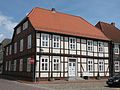
The old town in the vicinity of the fortress and the Elbe offers a closed cityscape with numerous half-timbered houses .
- Fortress Dömitz , flatland fortress from the 16th century, built between 1559 and 1565 at the time of the Mecklenburg Duke Johann Albrecht I to secure the southwest border of Mecklenburg and the crossings over the Elbe. The fortress is laid out in the shape of a pentagon and provided with bastions and casemate vaults. It has housed a museum on the region and the city since 1953 and has been a listed building since 1975.
- Two-storey town hall from 1820 in half-timbered construction with a mansard roof
- Railway bridge Dömitz , built from 1870 to 1873 for the Wendlandbahn of the Berlin-Hamburg Railway and used until the Second World War. After it was destroyed on April 20, 1945, it was not rebuilt because the Elbe was part of the inner-German border here. The illustration shows the remains on the opposite side of the Elbe from Dömitz.
- St. John's Church , neo-Gothic hall church with a cross-tent, 1869-1872 from brick built
- Half-timbered houses

Fire station
Rathausplatz 2

Rathausplatz 4

Am Wall 9

Elbstrasse 7

Elbstrasse 13

Torstrasse 29


Historical monuments
- Jewish cemetery with memorial stone
- VVN memorial plaque from 1950 at Goethestrasse 25 for Anna Wolfenstein, the last Jewish resident of Dömitz, who was deported by the Gestapo to the Theresienstadt concentration camp in 1942 and died there
- Memorial stone from 1949 on Slüterplatz (Ernst-Thälmann-Platz in GDR times) for the communist politician Ernst Thälmann who was murdered in Buchenwald concentration camp in 1944 .
Economy and Infrastructure
traffic

The federal highways B 191 ( Ludwigslust - Dannenberg ) and B 195 ( Boizenburg - Wittenberge) lead through Dömitz . To the west of the city is the Dömitz road bridge , on which the B 191 crosses the Elbe; it is the only bridge between Lauenburg and Wittenberge .
In April 1945, the railway bridge over the Elbe on the Wittenberge – Buchholz railway line was destroyed by an air raid, thus interrupting the connection between the Uelzen and Ludwigslust junctions . From this point on, Dömitz station was only the end point of the connection to Ludwigslust . Passenger traffic on this branch line was completely stopped in May 2000. The next train stations are now in Dannenberg in Lower Saxony, 14 kilometers away, and in Ludwigslust, 34 kilometers away.
The Elbe Cycle Path and the Mecklenburg Lakes Cycle Path lead through Dömitz.
education
- High school school center "Fritz Reuter" with elementary school, special school, productive learning , regional school and grammar school
Sports
The Dömitzer SV 06 offers football, sports gymnastics, table tennis and volleyball. The soccer team plays in the district league West Mecklenburg West in the 2019/20 season.
Personalities
sons and daughters of the town
- Joachim Slüter (around 1490–1532), clergyman and reformer
- Heinrich Carl Meinig (1736–1812), Hanseatic envoy in Copenhagen
- Friedrich Plener (1798–1864), railway and hydraulic engineer
- Karl von Waldow and Reitzenstein (1818–1888), politicians ( Conservative Party )
- Ludwig Kreutzer (1833–1902), writer
- Paul Bard (1839–1927), Evangelical Lutheran clergyman
- Hermann Koch (1856–1939), painter
- Johannes von Karpf (1867–1941), rear admiral
- August Schlettwein (1868–1916), administrative lawyer
- Adolf Schlettwein (1872–1939), civil servant
- Gustav Spangenberg (1884–1972), lawyer and senior church councilor
- Karl Müller (1896–1966), politician ( DP )
- Paul Reichert (1902–1978), politician, member of the state parliament ( DDP , CDU)
- Arthur Lange (1906–1972), resistance fighter against National Socialism
- Hans Sixtus (1907–1975), brewery manager and association official
- Dietrich Spangenberg (1922–1990), politician (SPD)
- Ilse-Maria Dorfstecher (1932–2020), gallery owner and curator
- Hartmut Brun (* 1950), journalist and literary researcher
- Henry Gawlick (* 1958), museum director
Personalities associated with Dömitz
- Joachim Christoph Janisch (1747–1808), mayor and councilor in Dömitz
- Fritz Reuter (1810–1874), writer, imprisoned at the Dömitz Fortress
- Johann Heinrich Runge (1811–1885), organ builder, built the organ in the Johanneskirche
- Adolf Heinrich Friedrich Schwarz (1812 – after 1859), doctor in Dömitz
- Eduard Paschen (1815–1910), doctor in Dömitz
- Theodor Krüger (1818–1885), architect, builder of the Johanneskirche
- Hans Werner Ohse (1898–1991), pastor in Dömitz
- Otto Karsten (1899–1967), politician (CDU), lived in Dömitz
- Georg Thomalla (1915–1999), actor, made his debut in Dömitz
- Heinz Kägebein (1924–2018), local researcher, teacher in Dömitz
Web links
Individual evidence
- ↑ Statistisches Amt MV - population status of the districts, offices and municipalities 2019 (XLS file) (official population figures in the update of the 2011 census) ( help ).
- ^ Regional Spatial Development Program West Mecklenburg (2011) , Regional Planning Association, accessed on July 12, 2015
- ↑ Main statute of the city of Dömitz. (PDF; 175 kB) City of Dömitz, December 18, 2014, accessed on February 1, 2016 .
- ↑ Geodata viewer of the Office for Geoinformation, Surveying and Cadastre of Mecklenburg-Western Pomerania ( information )
- ↑ Ernst Eichler and Werner Mühlmer: The names of cities in Mecklenburg-Vorpommern. Ingo Koch Verlag, Rostock 2002, ISBN 3-935319-23-1
- ↑ City Museum map
- ↑ Display board in the city museum
- ↑ Benno Prieß: Shot at Dawn , self-published, Calw 2002 (co-editor: State Commissioner for the Documents of the State Security Service of the GDR), ISBN 3-926802-36-7 , p. 218.
- ^ StBA: Changes in the municipalities in Germany, see 2004
- ↑ Population development of the districts and municipalities in Mecklenburg-Western Pomerania (Statistical Report AI of the Statistical Office Mecklenburg-Western Pomerania)
- ^ Result of the election for the city council on May 26, 2019
- ^ A retirement home for Renate Vollbrecht. In: Schweriner Volkszeitung , July 4, 2014.
- ↑ More culture in the fortress. In: Schweriner Volkszeitung , May 28, 2014.
- ^ Result of the mayoral election on June 16, 2019
- ↑ Hans-Heinz Schütt: On shield and flag - the coats of arms and flags of the state of Mecklenburg-Western Pomerania and its municipalities . Ed .: production office TINUS; Schwerin. 2011, ISBN 978-3-9814380-0-0 , pp. 119-121 .
- ↑ a b main statute § 1 (PDF).

Alt Krenzlin | Old Zachun | Balow | Bandenitz | Banzkow | Barkhagen | Barnin | Belsch | Bengerstorf | Possession | Blankenberg | Blievenstorf | Bobzin | Boizenburg / Elbe | Borkow | Brahlstorf | Brenz | Bresegard at Eldena | Bresegard near Picher | Bruel | Brunow | Bülow | Cambs | Crivitz | Dabel | Dambeck | Demes | Dersenow | Dobbertin | Dobin at the lake | Dömitz | Domsühl | Dumber | Eldena | Friedrichsruhe | Gallin | Gallin Cupcentess | Gammelin | Ganzlin | Gehlsbach | Gneven | Göhlen | Goldberg | Gorlose | Grabow | Granzin | Grebs-Niendorf | Greetings | Greven | Great Godems | Big stuff | Groß Laasch | Hagenow | Hohen Pritz | Holthusen | Hoort | Hülseburg | Parental leave | Karrenzin | Karstädt | Church of Jesar | Klein Rogahn | Tempzin Monastery | Kobrow | Kogel | Circling | Kremmin | Kritzow | Kuhlen-Wendorf | Cow peat | Langen Brütz | Leezen | Lewitzrand | Luebesse | Lueblow | Lübheen | Luebz | Ludwigslust | Lüttow-Valluhn | Malk Göhren | Malliss | Mestlin | Milow | Möllenbeck | Moraas | Muchow | Mustin | New Gülze | New Kaliss | New Poserin | Neustadt-Glewe | Nostorf | Upper Warnow | Pampow | Parchim | Passow | Pätow-Steegen | Picher | Pinnow | Plate | Plau am See | Prislich | Pritzier | Raben Steinfeld | Rastow | Redefin | Rome | Ruhner Mountains | Lap in | Schwanheide | Siggelkow | Spornitz | Sternberg | Stumble | Stralendorf | Straw churches | Sukow | Sülstorf | Techentin | Teldau | Ticino | Toddin | Tramm | Uelitz | Vellahn | Vielank | Warlitz | Warlow | Warsow | Weitendorf | Werder | Wittenburg | Wittendbod | Wittenförden | Witch | Wöbbelin | Zapel | Zarrentin am Schaalsee | Ziegendorf | Zierzow | Zölkow | Zulow