
Friedrichsruhe
| coat of arms | Germany map | |
|---|---|---|

|
Coordinates: 53 ° 32 ' N , 11 ° 46' E |
|
| Basic data | ||
| State : | Mecklenburg-Western Pomerania | |
| County : | Ludwigslust-Parchim | |
| Office : | Crivitz | |
| Height : | 49 m above sea level NHN | |
| Area : | 34.66 km 2 | |
| Residents: | 872 (Dec. 31, 2019) | |
| Population density : | 25 inhabitants per km 2 | |
| Postal code : | 19089 | |
| Area code : | 038723 | |
| License plate : | LUP, HGN, LBZ, LWL, PCH, STB | |
| Community key : | 13 0 76 038 | |
| Community structure: | 6 districts | |
| Office administration address: | Amtsstrasse 5 19089 Crivitz |
|
| Website : | ||
| Mayor : | Andreas Sturm ( Die Linke ) | |
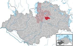
| Location of the community Friedrichsruhe in the district of Ludwigslust-Parchim | ||
  |
||

Friedrichsruhe is a municipality in the Ludwigslust-Parchim district in Mecklenburg-Western Pomerania . It is administered by the Crivitz Office , based in the city of the same name.
Geography and traffic
The community is located on federal highway 321 . The federal motorway 14 can be reached after about 19 kilometers via the Schwerin-Ost junction. The community is located about eight kilometers southeast of Crivitz and about 20 kilometers northwest of Parchim . Since 1899 it has had two stops on the Schwerin – Parchim railway line , one in Friedrichsruhe and one in the Ruthenbeck district. The municipality is mainly located in the lowlands to the left and right of the Mühlenbach, which rises in a pond landscape east of Friedrichsruhe. The 83.3 m above sea level. NHN highest point is the Tempelberg northeast of Frauenmark.
There is a train station in Ruthenbeck. From there, trains of the East German Railway run in the direction of Parchim and Rehna via Schwerin and Gadebusch. There is an hourly service there. There are parking spaces for cars and bicycles at the station.
Districts
- Frauenmark
- Friedrichsruhe village
- Friedrichsruhe Hof
- Goldenbow
- New Ruthenbeck
- Ruthenbeck
history
On January 1, 1951, the previously independent communities of Frauenmark and Goldenbow were incorporated.
On June 13, 2004, Ruthenbeck was incorporated. On July 1, 2004, the community came from the Eldetal to the Crivitz district.
politics
Coat of arms, flag, official seal
The municipality has no officially approved national emblem, neither a coat of arms nor a flag. The official seal is the small state seal with the coat of arms of the state of Mecklenburg. It shows a looking bull's head with torn off neck fur and crown and the inscription "GEMEINDE FRIEDRICHSRUHE".
Attractions
- Slavic ramparts and remains of settlements (the tribal center of the Smeldingen, which is not attested from written sources )
- Late Romanesque village church in Frauenmark
- Village church in Ruthenbeck
- Large stone graves of Frauenmark and large stone grave Ruthenbeck 1
- Goldenbow windmill
- Herrenhaus Frauenmark
- Gravestone above the grave of Gottfried Kindel in the cemetery of the Frauenmark district in memory of a resident who hoisted a white flag from the Bossow homestead in May 1945 and was therefore shot by SS men in front of his burned barn
- Memorial stone from 1949 on the B 321 in front of the local exit towards Schwerin for the prisoners of the death march of the Sachsenhausen concentration camp , who were driven through the village in April 1945. Since 1976 one of the 120 memorial plaques along the route has been providing information about this event.
- Memorial stone at kilometer 55 of the Neu-Ruthenbeck district to the victims of the death march
The architectural monuments of the community are listed in the list of architectural monuments in Friedrichsruhe .

Windmill in Goldenbow

Village church in Ruthenbeck
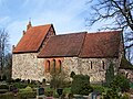
Village church in Frauenmark

Megalithic grave in Neu Ruthenbeck


Web links
- Information on excavations on the Slavic ramparts
- The website of the mill in Goldenbow
- Mill history
- Ortschronic von Goldenbow at Ortschroniken MV
Individual evidence
- ↑ Statistisches Amt MV - population status of the districts, offices and municipalities 2019 (XLS file) (official population figures in the update of the 2011 census) ( help ).
- ↑ Main statute of the community Friedrichsruhe. (PDF; 181 kB) Friedrichsruhe community, December 20, 2013, accessed on February 29, 2016 .
- ↑ Area changes in Mecklenburg-Western Pomerania 2004, State Statistical Office MV (PDF; 62 kB)
- ↑ Main Statute, Section 1, Paragraph 3
- ↑ Fred Ruchhöft, From the Slavic tribal area to the German bailiwick; the development of the territories in Ostholstein, Lauenburg, Mecklenburg and Western Pomerania in the Middle Ages. (Archeology and History in the Baltic Sea Region, Volume 4), Rahden / Westf. 2008 ISBN 978-3-89646-464-4 , page 91

Alt Krenzlin | Old Zachun | Balow | Bandenitz | Banzkow | Barkhagen | Barnin | Belsch | Bengerstorf | Possession | Blankenberg | Blievenstorf | Bobzin | Boizenburg / Elbe | Borkow | Brahlstorf | Brenz | Bresegard at Eldena | Bresegard near Picher | Bruel | Brunow | Bülow | Cambs | Crivitz | Dabel | Dambeck | Demes | Dersenow | Dobbertin | Dobin at the lake | Dömitz | Domsühl | Dumber | Eldena | Friedrichsruhe | Gallin | Gallin Cupcentess | Gammelin | Ganzlin | Gehlsbach | Gneven | Göhlen | Goldberg | Gorlose | Grabow | Granzin | Grebs-Niendorf | Greetings | Greven | Great Godems | Big stuff | Groß Laasch | Hagenow | Hohen Pritz | Holthusen | Hoort | Hülseburg | Parental leave | Karrenzin | Karstädt | Church of Jesar | Klein Rogahn | Tempzin Monastery | Kobrow | Kogel | Circling | Kremmin | Kritzow | Kuhlen-Wendorf | Cow peat | Langen Brütz | Leezen | Lewitzrand | Luebesse | Lueblow | Lübheen | Luebz | Ludwigslust | Lüttow-Valluhn | Malk Göhren | Malliss | Mestlin | Milow | Möllenbeck | Moraas | Muchow | Mustin | New Gülze | New Kaliss | New Poserin | Neustadt-Glewe | Nostorf | Upper Warnow | Pampow | Parchim | Passow | Pätow-Steegen | Picher | Pinnow | Plate | Plau am See | Prislich | Pritzier | Raben Steinfeld | Rastow | Redefin | Rome | Ruhner Mountains | Lap in | Schwanheide | Siggelkow | Spornitz | Sternberg | Stumble | Stralendorf | Straw churches | Sukow | Sülstorf | Techentin | Teldau | Ticino | Toddin | Tramm | Uelitz | Vellahn | Vielank | Warlitz | Warlow | Warsow | Weitendorf | Werder | Wittenburg | Wittendbod | Wittenförden | Witch | Wöbbelin | Zapel | Zarrentin am Schaalsee | Ziegendorf | Zierzow | Zölkow | Zulow