
Ennetbaden
| Ennetbaden | |
|---|---|
 |
|
| State : |
|
| Canton : |
|
| District : | to bathe |
| BFS no. : | 4026 |
| Postal code : | 5408 |
| Coordinates : | 665 984 / 259 085 |
| Height : | 355 m above sea level M. |
| Height range : | 347–756 m above sea level M. |
| Area : | 2.11 km² |
| Residents: | 3510 (December 31, 2019) |
| Population density : | 1664 inhabitants per km² |
|
Proportion of foreigners : (residents without citizenship ) |
23.1% (December 31, 2019) |
| Website: | www.ennetbaden.ch |
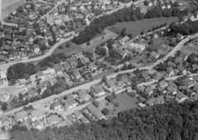
 Ennetbaden, view from the north |
|
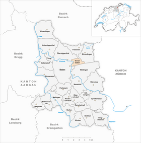
| Location of the municipality | |
  |
|
Ennetbaden ( Swiss German : ˈænːəˌpɑːdə ) is a municipality in the Swiss canton of Aargau . It belongs to the Baden district and, as the name suggests, is located opposite the city of Baden on the right bank of the Limmat . Ennetbaden used to be part of Baden, but has been an independent municipality since 1819.
geography

Ennetbaden has natural limits on all sides. The village is located in an approximately one and a half kilometer long, trough-shaped side valley of the Limmat between the Geissberg ( 586 m above sea level ) in the north and the Lägern and Klus von Baden in the south. The Lägern is the northeasternmost foothills of the Folded Jura , while the Geissberg is part of the Table Jura . The Limmat forms the western border, the Höhtal-Sattel the eastern border of the municipality. The development is concentrated on the banks of the Limmat and on the sunny southern slope of the Geissberg.
The area of the municipality is 211 hectares , of which 89 hectares are forested and 80 hectares are built over. The highest point is on the Lägerngrat at 757 meters, the lowest at 360 meters on the Limmat. Neighboring communities are Freienwil in the north, Ehrendingen in the east, Wettingen in the south, Baden in the west and Obersiggenthal in the north-west. Baden, Ennetbaden, Obersiggenthal and Wettingen form a coherent settlement area.
history
Excavations in 2008 revealed that around AD 120 the Romans had built a representative terrace building on the fire ruins of a craftsmen's quarter that had been built 80 years earlier and belonged to the Aquae Helveticae (Baden) settlement on the other side of the river. This was unusually luxurious with fresco paintings, mosaics, marble-clad walls and underfloor heating; Parts of the furniture were also preserved. The building was abandoned around 270 after raids by the Alemanni . A cemetery from the 7th century also came to light during the excavations.
Alio Badin was first mentioned in a document in 1150, the form Ennentbaden first appeared in 1410. The place name goes back to an Alemannic translation of Aquae Helveticae ( ze badun , "at the baths"), the differentiating preposition can be "beyond Baden" or "Baden on the other side (the Limmat)" mean. The settlement was an integral part of the city of Baden, but only the owners of the “small baths” on the banks of the Limmat had civil rights. The rest of the residents were rear residents who had to pay tithes to the monastery of St. Blasien . After the conquest of Aargau by the Confederates in 1415, Ennetbaden belonged to the County of Baden , a common rule . The tax liability increasingly shifted from the monastery to the city, without the Ennetbaden people being granted the same rights. Only in agricultural matters did they act independently through the "justice cooperative".
In March 1798 the French took Switzerland and proclaimed the Helvetic Republic . The Ennetbadener now sent a representative to the city council, but he only had a limited right of co-determination, so that tensions often arose. Baden found Ennetbaden as an annoying appendage, while Ennetbaden felt excluded from its larger neighbor. When the Ennetbaden residents refused to pay the police tax, in January 1817 the city council applied to the canton to separate the district and create an independent municipality from it. After long negotiations, the cantonal government issued a corresponding decree, which came into force on December 22, 1819 after the approval of the Grand Council . After the BBC was founded in Baden at the end of the 19th century, Ennetbaden developed into a preferred residential area. The spa business came to a standstill after the Second World War.
coat of arms
The blazon of the municipal coat of arms reads: "In yellow, black shield main post." After the separation from Baden, Ennetbaden continued to use the city arms unchanged. Only in 1942 was a separate coat of arms introduced. The shape was retained, only the colors changed. The yellow color is an allusion to the gold wall, the Ennetbaden vineyard.
Attractions

Ennetbaden, on the right bank of the Limmat, is connected to Baden's spa district by the Schiefe Brücke and the Mercier pedestrian walkway . The row of houses along the river bank is half rural and half urban. The Hotel Schwanen is well preserved . The “Schlössli”, a stately home, is located near the river. Its year of construction is not known, but it was probably built before 1543 and served as a country residence for noble Baden citizens. In 1800 the owner at that time had the building completely rebuilt in the late Baroque style. Of the old structure, only the round stair tower on the north side remained, which was raised by one story and provided with an onion dome.
population
The population developed as follows:
| year | 1850 | 1900 | 1930 | 1950 | 1960 | 1970 | 1980 | 1990 | 2000 | 2010 |
| Residents | 451 | 997 | 2223 | 2566 | 2963 | 3257 | 2702 | 2966 | 3019 | 3026 |
On December 31, 2019, 3510 people lived in Ennetbaden, the proportion of foreigners was 23.1%. In the 2015 census, 32.7% described themselves as Roman Catholic and 24.6% as Reformed ; 42.7% were non-denominational or of other faiths. In the 2000 census, 83.8% named German as their main language, 2.4% French , 2.2% Italian , 1.8% Serbo-Croatian , 1.7% each English and Portuguese , 1.3% Albanian and 1, 1% Turkish .
Politics and law
The assembly of those entitled to vote, the municipal assembly , exercises legislative power. The executing authority is the five-member municipal council . He is elected by the people in the majority procedure, his term of office is four years. The parish council leads and represents the parish. To this end, it implements the resolutions of the municipal assembly and the tasks assigned to it by the canton. The Baden District Court is responsible for litigation in the first instance . Ennetbaden belongs to the Friedensrichterkreis III (Baden).
economy
According to the corporate structure statistics (STATENT) collected in 2015, Ennetbaden has around 760 jobs, of which 2% in agriculture, 4% in industry and 94% in the service sector. Because of its sunny hillside location, the village is primarily a residential community. There are no large companies, but there are several small commercial and service companies. The vast majority of employed people work in the neighboring towns of Baden and Wettingen.
The wine industry is still important today. On the southern slope of the Geissberg, the so-called Goldwand, and partly also in the village center, an area of 9.1 hectares is planted with vines. Over a dozen varieties are planted, with Blauburgunder , Chardonnay and Riesling × Sylvaner predominating.
traffic

Kantonsstrasse 279 runs through Ennetbaden into Surbtal and Kantonsstrasse 295 into Siggenthal . The Baden train station is only a few minutes' walk away; Since June 2007 there has been a fast connection there for pedestrians and cyclists with a footbridge over the Limmat and the adjoining promenade lift. Ennetbaden is served by two RVBW bus routes as well as three post bus routes that run from Baden to Kaiserstuhl , Tegerfelden and Döttingen . On weekends, a night bus runs from Baden via the Surbtal and Klingnau to Bad Zurzach .
In the 20th century, Ennetbaden was heavily affected by through traffic, as a large part of the traffic from the north, from the western Limmat and Aare valleys moved over the Leaning Bridge to Baden, which was built in 1874 . In 2002 there was some relief from the construction of the Siggenthaler Bridge. In 2007 the Goldwand Tunnel was finally opened to traffic, which freed the core and bathing zone from through traffic along the Limmat. At the same time, the Schiefe Brücke was closed to private traffic, which largely relieved traffic noise for both Ennetbaden and Baden's spa district.
education
Due to the close proximity to Baden, there is only one primary school in Ennetbaden . All upper levels of the compulsory elementary school ( Realschule , Secondary School , District School ) can be attended in Baden. The closest grammar schools are the Baden Cantonal School and the Wettingen Cantonal School .
Personalities
- Eugen Schneider (1880–1953), architect and politician
- Carl Schmid (1894–1988), engineer
- Werner Nefflen (1919–2014), photographer
- Arthur Häny (1924–2019), writer and translator
- Anita Niesz (1925–2013), photographer
- Tobias Wildi (* 1973), historian, archivist and entrepreneur
- Simon Libsig (* 1977), writer
literature
- Andreas Steigmeier : Ennetbaden. In: Historical Lexicon of Switzerland .
- Peter Hoegger: The art monuments of the canton of Aargau . Ed .: Society for Swiss Art History. Volume VI, District of Baden I. Birkhäuser, Basel 1976, ISBN 3-7643-0782-X .
- Thomas Bolt, Uli Münzel: The spa district of Baden and Ennetbaden . In: Swiss art guides . tape 399 . Society for Swiss Art History , Bern 1986, ISBN 3-85782-399-2 .
Web links
Individual evidence
- ↑ Cantonal population statistics 2019. Department of Finance and Resources, Statistics Aargau, March 30, 2020, accessed on April 2, 2019 .
- ↑ Cantonal population statistics 2019. Department of Finance and Resources, Statistics Aargau, March 30, 2020, accessed on April 2, 2019 .
- ↑ a b Beat Zehnder: The community names of the canton of Aargau . In: Historical Society of the Canton of Aargau (Ed.): Argovia . tape 100 . Verlag Sauerländer, Aarau 1991, ISBN 3-7941-3122-3 , p. 144-145 .
- ^ National map of Switzerland, sheet 1070, Swisstopo.
- ↑ Standard area statistics - municipalities according to 4 main areas. Federal Statistical Office , November 26, 2018, accessed on June 7, 2019 .
- ↑ A luxurious bath from Roman times uncovered. Neue Zürcher Zeitung , December 9, 2008, accessed January 20, 2010 .
- ↑ Urs Tremp: Scenes from a marriage. (PDF) In: Ennetbadener Post, No. 2/2008. Community of Ennetbaden, May 2008, pp. 10-13 , accessed on January 20, 2010 .
- ^ Joseph Galliker, Marcel Giger: Municipal coat of arms of the Canton of Aargau . Lehrmittelverlag des Kantons Aargau, book 2004, ISBN 3-906738-07-8 , p. 151 .
- ↑ Hoegger: The monuments of Canton Aargau, Volume VI. Pp. 348-359.
- ↑ Population development in the municipalities of the Canton of Aargau since 1850. (Excel) In: Eidg. Volkszählung 2000. Statistics Aargau, 2001, archived from the original on October 8, 2018 ; accessed on June 7, 2019 .
- ↑ Resident population by religious affiliation, 2015. (Excel) In: Population and Households, Community Tables 2015. Statistics Aargau, accessed on June 7, 2019 .
- ↑ Swiss Federal Census 2000: Economic resident population by main language as well as by districts and municipalities. (Excel) Statistics Aargau, archived from the original on August 10, 2018 ; accessed on June 7, 2019 .
- ↑ circles of justice of the peace. Canton of Aargau, accessed on June 18, 2019 .
- ↑ Statistics of the corporate structure (STATENT). (Excel, 157 kB) Statistics Aargau, 2016, accessed on June 7, 2019 .
- ↑ Grape harvest control 2018 Canton Aargau. (PDF, 2.4 MB) Agricultural Center Liebegg, 2019, accessed on June 18, 2019 .
Bathing | Bellikon | Bergdietikon | Birmenstorf | Things of honor | Ennetbaden | Fislisbach | Freienwil | Gibstorf | Killwangen | Künten | Mellingen | Mägenwil | Neuenhof | Niederrohrdorf | Oberrohrdorf | Obersiggenthal | Remetschwil | Spreitenbach | Stetten | Turgi | Untersiggenthal | Wettingen | Wohlenschwil | Würenlingen | Würenlos
Former municipalities: Büblikon | Dättwil | Kempfhof | Oberehrendingen | Oetlikon | Rohrdorf | Unterehrendingen
Canton of Aargau | Districts of the Canton of Aargau | Municipalities in the Canton of Aargau