
Stetten AG
| AG is the abbreviation for the canton of Aargau in Switzerland and is used to avoid confusion with other entries of the name Stetten . |
| Stetten | |
|---|---|
 |
|
| State : |
|
| Canton : |
|
| District : | to bathe |
| BFS no. : | 4041 |
| Postal code : | 5608 |
| UN / LOCODE : | CH STT |
| Coordinates : | 665 584 / 250265 |
| Height : | 383 m above sea level M. |
| Height range : | 346–435 m above sea level M. |
| Area : | 4.41 km² |
| Residents: | 2206 (December 31, 2019) |
| Population density : | 500 inhabitants per km² |
|
Proportion of foreigners : (residents without citizenship ) |
21.7% (December 31, 2019) |
| Website: | www.stetten-ag.ch |
 View of the village |
|
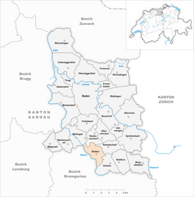
| Location of the municipality | |
  |
|
Stetten ( Swiss German : ˈʃtɛtːə ) is a municipality in the Swiss canton of Aargau . It belongs to the Baden district and is located in the Reuss Valley , roughly halfway between Baden and Bremgarten .
geography
The village center of Stetten is about half a kilometer northeast of the Reuss in the middle of a gently sloping plain. The Reuss has created a distinctive furrow in the gravel plain through erosion , in the Klosterfeld the Dorfbach flows into the river. There is a gravel pit on the eastern edge of the settlement ; it was created by completely removing the Honert moraine hill, on which the municipality's first water reservoir was once located. The industrial and commercial zone in the northeast has grown together with Busslingen .
The area of the municipality is 441 hectares , of which 120 hectares are covered with forest and 90 hectares are built over. The highest point is at 420 meters on the southeastern municipal boundary, the lowest at 348 meters on the Reuss. Neighboring communities are Niederrohrdorf in the north, Remetschwil in the east, Künten in the southeast, Niederwil in the south, Tägerig in the west and Mellingen in the northwest.
history
Various finds from the Neolithic , Latène and Roman times indicate an early settlement. It was first mentioned in a document in 998. The place name comes from the Old High German (ze) konstantin and means "near the dwellings". At that time the village was owned by the Einsiedeln monastery . The monasteries Engelberg , Hermetschwil , Königsfelden and Oetenbach were added as further landowners . In the Middle Ages the village was under the rule of the Kyburger , from 1273 under that of the Habsburgs .

In 1415 the Swiss conquered Aargau and Stetten was now part of the Rohrdorf office in the county of Baden , a common rule . In the same year the city of Mellingen acquired the lower jurisdiction , but as early as 1494 the villagers were able to buy themselves out of this rule. In 1529 the Rohrdorf parish, to which Stetten belonged until 1888, joined the Reformation . After the Second Kappel War in 1531, the residents of Stetten had to accept the Catholic denomination again.
In March 1798 the French took Switzerland and proclaimed the Helvetic Republic . Stetten was initially a municipality in the short-lived canton of Baden , since 1803 it has belonged to the canton of Aargau. Until well into the 20th century, Stetten was a village characterized by agriculture , supplemented by local small-scale industry and home work for the straw industry in Wohlen . That all changed in the 1960s when the village became more accessible and turned into a residential community after the nearby motorway opened. The population has almost tripled since 1970, and the 1980s in particular were marked by a construction boom.
In 2009, the renaturation of the village stream was initiated over a distance of 200 meters.
Attractions

Stetten has a largely intact village center with buildings from the late 18th and early 19th centuries that are well worth seeing. The history of the parish church of St. Vinzenz goes back to the 12th century. After the church tower was renewed in 1881, the rest of the building was also demolished in 1883/84 and a new building was built in the form of a hall church with a retracted choir closing on three sides .
coat of arms
The blazon of the municipal coat of arms reads: "A white double cross with a three-pointed foot, pawed in red, accompanied by two five-pointed white stars in the head of the shield." The coat of arms introduced in 1939 shows the Hungarian double cross. It is a reference to Queen Agnes of Hungary , who donated the Stetten farm to the Königsfelden monastery in 1352.
population
The population developed as follows:
| year | 1850 | 1900 | 1930 | 1950 | 1960 | 1970 | 1980 | 1990 | 2000 | 2010 |
| Residents | 498 | 429 | 463 | 512 | 544 | 786 | 958 | 1408 | 1547 | 1649 |
_komunuma_domo_134.jpg)
On December 31, 2019, 2,206 people lived in Stetten, the proportion of foreigners was 21.7%. In the 2015 census, 45.2% described themselves as Roman Catholic and 19.8% as Reformed ; 35.0% were non-denominational or of other faiths. In the 2000 census, 90.1% stated German as their main language, 2.5% Albanian , 1.9% Italian , 1.3% Serbo-Croatian , 1.0% Portuguese and 0.8% each of French and English .
Politics and law
The assembly of those entitled to vote, the municipal assembly , exercises legislative power. The executing authority is the five-member municipal council . He is elected by the people in the majority procedure, his term of office is four years. The parish council leads and represents the parish. To this end, it implements the resolutions of the municipal assembly and the tasks assigned to it by the canton. The Baden District Court is responsible for litigation in the first instance . Stetten belongs to the Friedensrichterkreis V (Mellingen).
economy
According to the corporate structure statistics (STATENT) collected in 2015, Stetten has around 860 jobs, 7% of them in agriculture, 70% in industry and 23% in the service sector. Most of the companies have settled in the industrial zone on the northeastern edge of the village. Companies in the construction industry play an important role. Stetten has about the same number of inbound and outbound commuters, and numerous people work in the Baden agglomeration .
traffic
_132.jpg)
Stetten is a little off the canton road 281 between Baden and Bremgarten , about six kilometers south of the Baden-West junction of the A1 motorway near Dättwil . Side roads lead to Wohlen , Mellingen and Künten . Two Postbus lines intersect in Stetten, on the one hand from the station Baden to Bremgarten, on the other hand from the station Wohlen to station Mellingen Heitersberg (connection to the train Zurich ). On weekends there is a night bus from Baden to Bremgarten.
education
The community has a kindergarten and a school house where primary school is taught. All upper levels ( Realschule , Secondary School and District School ) can be attended in Mellingen . The closest grammar schools are the Baden Cantonal School , the Wettingen Cantonal School and the Wohlen Cantonal School .
literature
- Patrick Zehnder: Stetten (AG). In: Historical Lexicon of Switzerland .
- Peter Hoegger: The art monuments of the canton of Aargau . Ed .: Society for Swiss Art History . Volume VI: District of Baden I. Birkhäuser Verlag, Basel 1976, ISBN 3-7643-0782-X .
- Urs Fischer: Our Stetten . Baden, 1992 (detailed village chronicle).
- Urs Fischer, Stetten. In: The Aargauer Communities 1991. Brugg 1990, p. 72f.
Web links
Individual evidence
- ↑ Cantonal population statistics 2019. Department of Finance and Resources, Statistics Aargau, March 30, 2020, accessed on April 2, 2019 .
- ↑ Cantonal population statistics 2019. Department of Finance and Resources, Statistics Aargau, March 30, 2020, accessed on April 2, 2019 .
- ↑ a b Beat Zehnder: The community names of the canton of Aargau . In: Historical Society of the Canton of Aargau (Ed.): Argovia . tape 100 . Verlag Sauerländer, Aarau 1991, ISBN 3-7941-3122-3 , p. 410 .
- ^ National map of Switzerland, sheet 1090, Swisstopo.
- ↑ Standard area statistics - municipalities according to 4 main areas. Federal Statistical Office , November 26, 2018, accessed on June 3, 2019 .
- ↑ Hans Christof Wagner: After the renaturation, the Dorfbach can flow freely again - cheaper than planned. In: Aargauer Zeitung . November 8, 2018, accessed December 13, 2018 .
- ↑ Hoegger: The monuments of Canton Aargau, Volume VI. Pp. 452-458.
- ^ Joseph Galliker, Marcel Giger: Municipal coat of arms of the Canton of Aargau . Lehrmittelverlag des Kantons Aargau, book 2004, ISBN 3-906738-07-8 , p. 283 .
- ↑ Population development in the municipalities of the Canton of Aargau since 1850. (Excel) In: Eidg. Volkszählung 2000. Statistics Aargau, 2001, archived from the original on October 8, 2018 ; accessed on June 3, 2019 .
- ↑ Resident population by religious affiliation, 2015. (Excel) In: Population and Households, Community Tables 2015. Statistics Aargau, accessed on June 3, 2019 .
- ↑ Swiss Federal Census 2000: Economic resident population by main language as well as by districts and municipalities. (Excel) Statistics Aargau, archived from the original on August 10, 2018 ; accessed on June 3, 2019 .
- ↑ circles of justice of the peace. Canton of Aargau, accessed on June 19, 2019 .
- ↑ Statistics of the corporate structure (STATENT). (Excel, 157 kB) Statistics Aargau, 2016, accessed on June 3, 2019 .
Bathing | Bellikon | Bergdietikon | Birmenstorf | Things of honor | Ennetbaden | Fislisbach | Freienwil | Gibstorf | Killwangen | Künten | Mellingen | Mägenwil | Neuenhof | Niederrohrdorf | Oberrohrdorf | Obersiggenthal | Remetschwil | Spreitenbach | Stetten | Turgi | Untersiggenthal | Wettingen | Wohlenschwil | Würenlingen | Würenlos
Former municipalities: Büblikon | Dättwil | Kempfhof | Oberehrendingen | Oetlikon | Rohrdorf | Unterehrendingen
Canton of Aargau | Districts of the Canton of Aargau | Municipalities in the Canton of Aargau