
Upper honorable things
| Upper honorable things | ||
|---|---|---|
 |
||
| State : |
|
|
| Canton : |
|
|
| District : | to bathe | |
| Residential municipality : | Things of honor | |
| Postal code : | 5420 | |
| former BFS no. : | 4036 | |
| Coordinates : | 668 053 / 260 839 | |
| Height : | 465 m above sea level M. | |
| Residents: | 2018 (December 31, 2004) | |
|
Proportion of foreigners : (residents without citizenship ) |
- | |
| map | ||
|
||

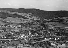
Oberehrendingen is a village in the Swiss canton of Aargau . It belongs to the municipality Ehrendingen in the Baden district , is located three kilometers northeast of the district capital and was an independent political municipality from 1825 until it merged with Unterehrendingen on January 1, 2006.
geography
The village lies in a cut in the terrain at the north foot of the camps . The incision, which runs roughly in a south-north direction, begins at the Höhtal, the 500-meter-high transition into the Limmattal , and extends to the Surbtal . The development has grown together seamlessly with that of Unterehrendingen and follows the village stream that rises on the Lägern. The foothills of the Siggenberg extend to the west . The area of the former municipality was 398 hectares .
history

Individual finds prove that the area north of the camps was already populated during the Neolithic and Bronze Ages. The village was first mentioned in 1040 as Aradingin . The name is of Alemannic origin and means "among the people of the Arinrat". In the 11th century the Einsiedeln monastery acquired large estates. The Elchingen monastery near Ulm exchanged its properties with the Sankt Blasien monastery in 1150 . The rulers were the Habsburgs .
In 1415 the Swiss conquered Aargau and Ehrendingen was henceforth the capital of the district of the same name in the county of Baden , a common rule . Both the lower courts as well as the court rights were by the bailiff in Baden exercised. In March 1798 the French took Switzerland and proclaimed the Helvetic Republic . Ehrendingen was initially a municipality in the short-lived canton of Baden ; from 1803 it belonged to the canton of Aargau. In 1821 a village fire raged and destroyed numerous houses.
In 1825 Ehrendingen was divided into the two independent communities of Ober- and Unterehrendingen. From 1892 to 1902 the Lägern cement factory employed up to 400 workers. The population grew only slightly until 1950. But then, due to the proximity to Baden and Zurich , increased construction activity began. The population doubled, the village became a popular residential community and grew together with the neighboring Unterehrendingen. Ober- and Unterehrendingen gradually developed a common identity and decided to reunify in 2003. On January 1, 2006, after an interruption of 181 years, the Ehrendingen community was re-established .
coat of arms
The blazon of the former municipal coat of arms reads: "Yellow deer walking in blue on a green hill." The community seal from 1872, the first with a coat of arms, showed a standing stag, but in an unusual legal position (heraldic left). In 1915 the stag was swept into its usual position. The heraldic animal is reminiscent of Sankt Blasien .
population

Population development:
| year | 1844 | 1900 | 1930 | 1950 | 1960 | 1970 | 1980 | 1990 | 2000 |
| Residents | 518 | 657 | 810 | 884 | 1193 | 1497 | 1489 | 1597 | 1767 |
On December 31, 2004, a year before the merger, there were people living in Oberehrendingen in 2018; the proportion of foreigners was 13.1%. At the 2000 census, 55.7% were Roman Catholic, 28.9% Reformed, and 2.2% Muslim; 1.6% were of other faiths. 91.6% said their main language was German, 1.6% Italian, 1.1% Albanian, 1.0% English, 0.8% French.
traffic
Oberehrendingen is on Kantonsstrasse 279 between Baden and the Surbtal; Kantonsstrasse 478 leads to Freienwil . The village is accessed by three postbus lines that run from Baden train station to Endingen , Kaiserstuhl and Tegerfelden . The train station in the neighboring community of Niederweningen is the terminus of a line of the Zurich S-Bahn . On weekends, a night bus runs from Baden via Oberehrendingen and Klingnau to Bad Zurzach .
Attractions
literature
- Patrick Zehnder: Oberehrendingen. In: Historical Lexicon of Switzerland .
- Peter Hoegger: The art monuments of the canton of Aargau . Ed .: Society for Swiss Art History . Volume VII: District of Baden II. Birkhäuser Verlag, Basel 1995, ISBN 3-909164-44-7 , p. 75-88 .
Individual evidence
- ^ Item 14: cement factory. In: Ehrendinger Runde. Ehrendingen community, archived from the original on December 26, 2017 ; Retrieved December 25, 2017 .
- ↑ Population development in the municipalities of the Canton of Aargau since 1850. (Excel) In: Eidg. Volkszählung 2000. Statistics Aargau, 2001, archived from the original on October 8, 2018 ; accessed on June 18, 2019 .
Bathing | Bellikon | Bergdietikon | Birmenstorf | Things of honor | Ennetbaden | Fislisbach | Freienwil | Gibstorf | Killwangen | Künten | Mellingen | Mägenwil | Neuenhof | Niederrohrdorf | Oberrohrdorf | Obersiggenthal | Remetschwil | Spreitenbach | Stetten | Turgi | Untersiggenthal | Wettingen | Wohlenschwil | Würenlingen | Würenlos
Former municipalities: Büblikon | Dättwil | Kempfhof | Oberehrendingen | Oetlikon | Rohrdorf | Unterehrendingen
Canton of Aargau | Districts of the Canton of Aargau | Municipalities in the Canton of Aargau