
Oberrohrdorf
| Oberrohrdorf | |
|---|---|
 |
|
| State : |
|
| Canton : |
|
| District : | to bathe |
| BFS no. : | 4037 |
| Postal code : | 5452 |
| UN / LOCODE : | CH ORD |
| Coordinates : | 666.26 thousand / 252 407 |
| Height : | 495 m above sea level M. |
| Height range : | 445–702 m above sea level M. |
| Area : | 4.30 km² |
| Residents: | 4086 (December 31, 2019) |
| Population density : | 950 inhabitants per km² |
|
Proportion of foreigners : (residents without citizenship ) |
17.6% (December 31, 2019) |
| Website: | www.oberrohrdorf.ch |
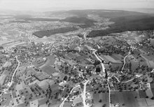
 View of Nieder- and Oberrohrdorf |
|
| Location of the municipality | |
  |
|
Oberrohrdorf (in local Swiss German : Oberroodlef, ˈɔbər, roːdləf ) is a municipality in the Swiss canton of Aargau . It belongs to the Baden district and is located on the edge of the Reuss Valley , between the district capital of Baden and the Mutschellen Pass .
geography
The community is located about three kilometers east of the Reuss on the evenly sloping southwest slope of the Rohrdorferberg. This survey forms part of the Heitersberg -Hügelkette that the Reuss River Valley from further east Limmattal separates. The western part of the municipality consists of low terrace gravel that was deposited by the Reuss glacier during the Würm glacial period . Older gravel from the Glacial Riss (150,000 to 200,000 years ago) can be found further up the slope . The intermediate zones are partially filled with alluvial clay.
About one kilometer north of the village center is the Staretschwil district on a lateral moraine , at an altitude of 550 m above sea level. M. Both Oberrohrdorf and Staretschwil have grown together completely with the development of the lower Niederrohrdorf, the borders between the once separate villages can hardly be made out.
The area of the municipality is 430 hectares , of which 162 hectares are forested and 104 hectares are built over. The highest point is on the ridge of the Heitersberg at 702 meters, the lowest at 455 meters on the western boundary of the municipality. Neighboring communities are Neuenhof in the northeast, Killwangen in the east, Spreitenbach in the southeast, Remetschwil in the south, Niederrohrdorf in the west and Fislisbach in the northwest.
history
Archaeological finds from prehistoric times are relatively rare on the Rohrdorferberg, the oldest in the municipality go back to the Hallstatt period around 2800 years ago. From various finds in neighboring communities, however, it can be concluded that the area could have been inhabited during the early Mesolithic around 11,500 years ago. During the Roman era , a road possibly led from Dättwil over the southwest slope of the Rohrdorferberg to Lunnern near Obfelden . According to place names , Oberrohrdorf was settled by the Alamanni between the 6th and 8th centuries , Staretschwil in a later settlement phase between the 8th and 11th centuries.
Rordorf is said to have been mentioned for the first time around 1040 in the Liber Heremi of the Einsiedeln monastery ; however, only a copy of this document from the 15th century has survived. The oldest surviving original document with the name of the place, an umbrella letter of the Muri monastery issued by Pope Hadrian IV , is dated March 11, 1159. In the Habsburg land register of 1303/07, the settlement of Oberen-Rordorf is mentioned for the first time . The place name comes from the Old High German Rorthorf and means "reed village".
In the 11th and early 12th centuries, the barons of Sellenbüren presumably ruled the Rohrdorferberg. The area later came under the control of the Habsburgs , who also had considerable property here and, after 1259, took over the patronage rights of the Rohrdorf Church from the Murbach Monastery . The Habsburgs secured sovereignty for themselves in 1273 after the rival family of the Counts of Kyburg had died out. Ministeriale took on administrative tasks on their behalf, initially the lords of Rüssegg, from 1344 the lords of Hünenberg. In the first half of the 14th century the office of Rohrdorf was formed, which largely coincided with the area of the parish. The monasteries of Muri , Wettingen and Gnadenthal were important landowners . In 1413 Duke Friedrich IV sold the Rohrdorf church set to the Agness Hospital in Baden .
In April and May 1415 the Confederates conquered Aargau and the office of Rohrdorf from the Habsburgs. Oberrohrdorf was now part of the county of Baden , a common rule . The federal provincial bailiff , who changes every two years and resides in Baden, exercised sovereignty and blood jurisdiction . In Oberrohrdorf it was also in the possession of the lower jurisdiction , while in Staretschwil the Wettingen monastery held this task. The Staretschwil opening , which regulated the relationship between the court lord and the village population, was created around 1420. The corresponding original document for Oberrohrdorf was lost in a fire in 1596. Under the leadership of Pastor Heinrich Buchmann, the brother of Theodor Bibliander , the Rohrdorf parish converted to the Reformation in 1529 . Two years later, after the Reformed towns were defeated in the Second Kappel War , the population had to reassume the Catholic denomination. Towards the end of the Peasant War of 1653, the Rohrdorferberg was the deployment area of the Zurich troops on the way to the decisive battle near Wohlenschwil . During the Second Villmerger War of 1712, the Catholic Central Swiss towns occupied the range of hills between the Reuss and Limmat valleys on May 12th. There were repeated raids; Among other things, residents of the Rohrdorferberg attacked the mill in Spreitenbach . Around 5,000 people from Zurich advanced on May 21 over the Heitersberg towards Mellingen . Oberrohrdorf was badly plundered by the troops and part of the parish archive was lost.
The old system of rule collapsed in 1798 with the French invasion and the proclamation of the Helvetic Republic . Several residents of the Rohrdorferberg offered resistance against the new revolutionary order, but the French troops defeated it in the battle near Hägglingen . In the new unified state, Oberrohrdorf was a municipality in the Baden district of the short-lived Canton of Baden . The village of Staretschwil belonged to the municipality of Niederrohrdorf. With the mediation constitution of 1803, the new canton Aargau came into being and Oberrohrdorf merged with Busslingen . In 1805 Busslingen, Niederrohrdorf, Oberrohrdorf, Remetschwil and Staretschwil united to form the municipality of Rohrdorf , with the five parts of the municipality each having a representative on the municipal council. How this merger came about is unclear, as the sources do not describe the process in detail. The driving forces were District Administrator Johann Ludwig Baldinger and Justice of the Peace Johann Vogler, who presumably had made some decisions arrogantly and disregarded the democratic right of co-determination.


The Rohrdorf community was structurally weak. Life was almost exclusively geared towards agriculture, with the few businesses serving local needs. The replacement of the feudal burden dragged on for decades. Due to poverty and famine, waves of emigration occurred after 1816 (“ year without a summer ”) and again in the 1840s. There were repeated efforts by the partly autonomous village communities to separate the large community again, because the cooperation in organizational and financial matters did not work smoothly. The cantonal government rejected such requests in 1813, 1816, 1832, 1842, 1850 and 1853. All of the requests came from Remetschwil, while Staretschwil and Busslingen mostly did not support them. Finally, the Grand Council asked the government to carry out the separation. In 1854 Rohrdorf was separated into the three communities Niederrohrdorf, Oberrohrdorf and Remetschwil. Busslingen was merged with Remetschwil, Staretschwil with Oberrohrdorf. The administrative structures remained complex: In addition to the community assembly of the entire community, there was a local residents and local citizens ' assembly in Oberrohrdorf and Staretschwil , which resulted in a total of five corporations. In 1965, Staretschwil wanted to split off, but the local residents' community of Oberrohrdorf and the entire community refused. Finally, both local resident communities were merged in 1974, the merger of the local communities did not take place until 2007.
From the middle of the 19th century, the economy gradually diversified. Businesses began to settle there that produced beyond the purely local market. The mechanization of agriculture made it necessary to amalgamate the many small plots in order to be able to manage them more efficiently. However, the necessary regulation of goods took place until 1939. In 1891 the construction of a water supply network began on a cooperative basis. In 1911 it was connected to the power grid; While a cooperative in Oberrohrdorf was responsible for setting up and maintaining the local network, Motor AG set up the Staretschwil network. At the beginning of the Second World War , the Swiss Army expanded the position of the Limmat , which included a complex system of fortifications on the Heitersberg range of hills; An artillery position was built in the Buacher near Oberrohrdorf. With the Réduit strategy , the Limmat position lost its importance in the summer of 1940 and the troops billeted in the village were withdrawn. The Wahlen plan required a significant increase in the cultivation area.
At the end of the 1950s there was a lot of construction activity in the centers of Baden and Zurich due to the settlement pressure. The population increase was particularly strong in the 1960s, when the number of inhabitants more than doubled; in the 1970s it rose by a further 50% and then gradually flattened out. Individual multi-family houses and extensive terraced settlements on hillside displaced the rural, rural village structure in just a few years. In 1964 a zoning plan was passed in order not to let the unchecked building activity get out of hand. The built-up area grew together with that of Niederrohrdorf, and there was no longer any visible border with Staretschwil either. Since the beginning of the 21st century there has been a marked increase in the population. In 2005 there were considerations to aim for a merger with the neighboring municipality of Niederrohrdorf, which should have taken place in 2010. While the Niederrohrdorf community assembly approved a corresponding planning loan, this was rejected in Oberrohrdorf.
Attractions

The parish church of St. Martin dates back to the 11th century. Around 1640 a new baroque building was built, with the medieval church tower being retained. The church proved to be too small three centuries later, which is why the parish demolished it in 1939 and had a much larger structure replaced. The church tower, whose ground floor dates from the 14th century, has been preserved in its original condition. Next to the church is the rectory built in 1751/53. The oldest building in the community is the late medieval tithe barn of the Baden Agness Hospital, which is now used as a cultural center.
In the middle of the settlement area was the largest free-growing Christmas tree in Europe, a 44-meter-high sequoia tree , which was first assembled during the Christmas season in 2005 and decorated with over 2,000 electric candle lights. It was felled in 2015 due to a fungal attack.
coat of arms
The blazon of the municipal coat of arms reads: "In red on a green three-mountain, a yellow imperial orb with a double cross, raised by a six-pointed white star, topped by two black cattails on green leafy stems." The illustration goes back to the official municipal seal of 1811.
population
The population developed as follows:
| year | 1780 | 1803 | 1860 | 1900 | 1930 | 1950 | 1960 | 1970 | 1980 | 1990 | 2000 | 2010 |
| Residents | 267 | 185 | 594 | 625 | 772 | 815 | 921 | 1880 | 2863 | 3303 | 3364 | 3880 |
On December 31, 2019, 4086 people lived in Oberrohrdorf, the proportion of foreigners was 17.6%. In the 2015 census, 38.8% described themselves as Roman Catholic and 24.3% as Reformed ; 36.9% were non-denominational or of other faiths. 91.0% said German as their main language in the 2000 census , 1.2% Italian , 1.1% each in Albanian and Turkish, and 1.0% French .
Politics and law

The assembly of those entitled to vote, the municipal assembly , exercises legislative power. The executing authority is the five-member municipal council . He is elected by the people in the majority procedure, his term of office is four years. The parish council leads and represents the parish. To this end, it implements the resolutions of the municipal assembly and the tasks assigned to it by the canton. The Baden District Court is responsible for litigation in the first instance . Oberrohrdorf belongs to the judges' circle V (Mellingen).
economy
According to the corporate structure statistics (STATENT) collected in 2015, Oberrohrdorf has around 880 jobs, 3% of them in agriculture, 18% in industry and 79% in the service sector. Most of the employed are commuters and work in the Baden agglomeration .
traffic
Oberrohrdorf is located on Kantonsstrasse 282 between Baden and the Mutschellen -Passhöhe, about five kilometers south of the Baden-West junction of the A1 motorway near Dättwil . Two postbus lines run through the village from Baden train station to Berikon-Widen (stop of the Bremgarten-Dietikon train ); one drives here directly from Dättwil, while the other makes a short detour via Fislisbach and Niederrohrdorf. Two other lines run from Mellingen Heitersberg train station (connection to the Zurich S-Bahn ) via Oberrohrdorf to Dättwil and Widen . In addition, Oberrohrdorf is the terminus of a Limmat Bus express bus line to Zurich Enge train station . On weekends there is a night bus from Baden to Berikon-Widen.
education
In Oberrohrdorf there are five kindergartens and a school house in which the primary school is taught. The four communities Bellikon , Niederrohrdorf , Oberrohrdorf and Remetschwil are the sponsors of the community association Kreisschule Rohrdorferberg. Around 300 learners in 16 classes of the district, secondary and junior high school are taught in the upper school center in Niederrohrdorf. The closest grammar schools are the Baden Cantonal School and the Wettingen Cantonal School .
The first school on Rohrdorferberg existed from the second half of the 17th century in Oberrohrdorf; it was a "winter school" that provided only the bare minimum of education. After the introduction of compulsory schooling in 1805, the offer was gradually expanded. In 1814 a school building was built in Oberrohrdorf, which was replaced by a new building in 1901 (has served as the community center since 1975). In 1895 Staretschwil got its own school house. In 1953 the secondary school started teaching, in 1974 the Hinterbächli school center was opened, and the old Staretschwil schoolhouse has been used for music lessons ever since.
Personalities
- Martin Merki (1931–2014), journalist
- Martin Reimann (1798–1878), Abbot of Wettingen-Mehrerau
- Markus Somm (* 1965), journalist
- Dieter Stamm (* 1965), author and journalist
- Martin Vogler (1830–1903), politician and manufacturer
literature
- Patrick Zehnder: Oberrohrdorf. In: Historical Lexicon of Switzerland .
- Fabian Furter, Martin Handschin, Bruno Meier , René Roca, Miriam Rorato: Rohrdorferberg - history of Oberrohrdorf, Niederrohrdorf and Remetschwil . 2011.
- Peter Hoegger: The art monuments of the canton of Aargau . Ed .: Society for Swiss Art History . Volume VI: District of Baden I. Birkhäuser Verlag, Basel 1976, ISBN 3-7643-0782-X .
Web links
Individual evidence
- ↑ Cantonal population statistics 2019. Department of Finance and Resources, Statistics Aargau, March 30, 2020, accessed on April 2, 2019 .
- ↑ Cantonal population statistics 2019. Department of Finance and Resources, Statistics Aargau, March 30, 2020, accessed on April 2, 2019 .
- ^ Furter et al .: Rohrdorferberg. Pp. 18-19.
- ^ National map of Switzerland, sheet 1090, Swisstopo.
- ↑ Standard area statistics - municipalities according to 4 main areas. Federal Statistical Office , November 26, 2018, accessed on June 1, 2019 .
- ^ Furter et al .: Rohrdorferberg. P. 20.
- ^ Furter et al .: Rohrdorferberg. P. 22.
- ^ Furter et al .: Rohrdorferberg. P. 26.
- ^ Beat Zehnder: The community names of the canton of Aargau . In: Historical Society of the Canton of Aargau (Ed.): Argovia . tape 100 . Verlag Sauerländer, Aarau 1991, ISBN 3-7941-3122-3 , p. 302-303 .
- ^ Furter et al .: Rohrdorferberg. Pp. 27-33.
- ^ Furter et al .: Rohrdorferberg. Pp. 36-37.
- ^ Furter et al .: Rohrdorferberg. P. 41.
- ^ Furter et al .: Rohrdorferberg. P. 49.
- ^ Furter et al .: Rohrdorferberg. Pp. 46-47.
- ^ Furter et al .: Rohrdorferberg. Pp. 90-92.
- ^ Furter et al .: Rohrdorferberg. Pp. 103-104.
- ^ Furter et al .: Rohrdorferberg. P. 127.
- ^ Furter et al .: Rohrdorferberg. P. 129.
- ^ Furter et al .: Rohrdorferberg. Pp. 225-226.
- ^ Furter et al .: Rohrdorferberg. Pp. 159-160.
- ^ Furter et al .: Rohrdorferberg. Pp. 276-277.
- ^ Furter et al .: Rohrdorferberg. Pp. 192-197.
- ^ Furter et al .: Rohrdorferberg. Pp. 293-294.
- ^ Furter et al .: Rohrdorferberg. P. 227.
- ↑ Hoegger: The monuments of Canton Aargau, Volume VI. Pp. 436-439.
- ↑ Mammoth Christmas ( Memento of 8 September 2010 at the Internet Archive )
- ↑ A giant falls: Oberrohrdorf loses its sequoia tree. Retrieved on May 5, 2020 (Swiss Standard German).
- ^ Joseph Galliker, Marcel Giger: Municipal coat of arms of the Canton of Aargau . Lehrmittelverlag des Kantons Aargau, book 2004, ISBN 3-906738-07-8 , p. 239 .
- ↑ Population development in the municipalities of the Canton of Aargau since 1850. (Excel) In: Eidg. Volkszählung 2000. Statistics Aargau, 2001, archived from the original on October 8, 2018 ; accessed on June 1, 2019 .
- ↑ Resident population by religious affiliation, 2015. (Excel) In: Population and Households, Community Tables 2015. Statistics Aargau, accessed on June 1, 2019 .
- ↑ Swiss Federal Census 2000: Economic resident population by main language as well as by districts and municipalities. (Excel) Statistics Aargau, archived from the original on August 10, 2018 ; accessed on June 1, 2019 .
- ↑ circles of justice of the peace. Canton of Aargau, accessed on June 19, 2019 .
- ↑ Statistics of the corporate structure (STATENT). (Excel, 157 kB) Statistics Aargau, 2016, accessed on June 1, 2019 .
- ^ Furter et al .: Rohrdorferberg. Pp. 136-140.
- ^ Furter et al .: Rohrdorferberg. Pp. 282-284.
Bathing | Bellikon | Bergdietikon | Birmenstorf | Things of honor | Ennetbaden | Fislisbach | Freienwil | Gibstorf | Killwangen | Künten | Mellingen | Mägenwil | Neuenhof | Niederrohrdorf | Oberrohrdorf | Obersiggenthal | Remetschwil | Spreitenbach | Stetten | Turgi | Untersiggenthal | Wettingen | Wohlenschwil | Würenlingen | Würenlos
Former municipalities: Büblikon | Dättwil | Kempfhof | Oberehrendingen | Oetlikon | Rohrdorf | Unterehrendingen
Canton of Aargau | Districts of the Canton of Aargau | Municipalities in the Canton of Aargau