Fatulia
| Fatulia | ||

|
||

|
||
| Data | ||
| surface | 32.77 km² | |
| population | 2,788 (2015) | |
| Chefe de Suco | Angelino Moises (election 2016) |
|
| Aldeias | Population (2015) | |
| Bahadato | 918 | |
| Osso-uaque | 670 | |
| Uai-To-Bono | 553 | |
| Uatulia-Ana | 647 | |
|
|
||
Fatulia is an East Timorese place and Suco in the administrative office Venilale ( municipality of Baucau ).
The place
The place Fatulia is located in the northeast of Sucos, at an altitude of 888 m . Here is the primary school of sucos, the Escola Primaria catolica Fatulia .
The Suco
| Fatulia | ||
| places | position | height |
| Bahadato | 8 ° 39 ′ S , 126 ° 22 ′ E | 752 m |
| Fatulia | 8 ° 38 ' S , 126 ° 22' E | 888 m |
| Osso-uaque | 8 ° 39 ′ S , 126 ° 22 ′ E | 752 m |
| Uai-To-Bono | 8 ° 39 ′ S , 126 ° 22 ′ E | 802 m |
| Uatulia-Ana | 8 ° 39 ′ S , 126 ° 22 ′ E | 781 m |
In Fatulia live 2788 inhabitants (2015), of which 1371 are men and 1417 women. The population density is 85.1 inhabitants / km². There are 499 households in the Suco. About 90% of the population name Midiki as their mother tongue. About 10% speak Tetum Prasa .
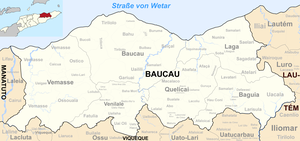
Before the territorial reform in 2015, Fatulia had an area of 30.32 km². Now there are 32.77 km². The Suco is located in the southwest of the administrative office Venilale. To the east are the sucos Uailaha and Uatu Haco , to the northeast of the Suco Baha Mori . In the west Fatulia borders on the administrative office Vemasse with its sucos Ossouala and Loilubo and in the south on the administrative office Ossu belonging to the municipality Viqueque with its sucos Liaruca and Builale . The Suni , a tributary of the Vemasse, has its source in the west of the Sucos . The Assalaenita , part of the Seiçal river system, flows along part of the border with Builale .
The overland road between the places Venilale and Ossu largely follows the border between the Sucos Fatulia and Uailaha. The places Uatulia ( Uatolia ) and Uai-To-Bono ( Uatobono , Uaito Bonu ) are located on it. Uatolia is practically a suburb of the administrative capital Venilale. A little further west are the villages of Fatulia, Osso-Uaque ( Osso Uaque , Ossoake , Osowake ) and Bahadato ( Baha-Dato , Bahadatu ). There is a medical station in the west of Sucos.
In the Suco are the four Aldeias Bahadato , Osso-Uaque , Uai-To-Bono and Uatulia-Ana .
history
In March 1988, four men from Fatulia were arrested by Indonesian soldiers and taken to the base of the 328 Infantry Battalion. In order to find out where the FALINTIL was hiding , the men were interrogated and tortured. One of them was executed.
On August 6, 2015, there was a firefight in Osso-Uaque between the East Timorese police and army on the one hand and the rebel group KRM . One KRM member was killed, a police officer and a soldier were seriously injured.
politics
In the elections of 2004/2005 was Constancio José do Rego elected Chefe de Suco and in 2009 re-elected. In the elections in 2016 Angelino Moises won.
Web links
- Results of the 2010 census for the Suco Fatulia ( tetum ; PDF; 8.6 MB)
- Results of the 2015 census for Suco Fatulia (tetum; PDF)
- Seeds of Life: Suco information sheets Venilale (tetum)
Individual evidence
- ↑ a b c d Direcção-Geral de Estatística : Results of the 2015 census , accessed on November 23, 2016.
- ↑ List of polling stations for the parliamentary elections in East Timor 2007 (PDF file; 118 kB)
- ↑ Fallingrain.com: Directory of Cities, Towns, and Regions in East Timor
- ↑ Results of the 2010 census for the Suco Fatulia ( tetum ; PDF; 8.6 MB)
- ↑ Direcção Nacional de Estatística: Population Distribution by Administrative Areas Volume 2 English ( Memento of the original from January 5, 2017 in the Internet Archive ) Info: The archive link has been inserted automatically and has not yet been checked. Please check the original and archive link according to the instructions and then remove this notice. (2010 census; PDF; 22.6 MB)
- ↑ a b Timor-Leste GIS Portal ( Memento from June 30, 2007 in the Internet Archive )
- ↑ UNMIT: Timor-Leste District Atlas version 02, August 2008 ( Memento of the original from December 3, 2011 in the Internet Archive ) Info: The archive link has been inserted automatically and has not yet been checked. Please check the original and archive link according to the instructions and then remove this notice. (PDF; 499 kB)
- ↑ Jornal da Républica with the Diploma Ministerial n. 199/09 ( Memento of February 3, 2010 in the Internet Archive ) (Portuguese; PDF; 323 kB)
- ↑ "Chapter 7.2 Unlawful Killings and Enforced Disappearances" ( Memento of the original from November 5, 2013 in the Internet Archive ) Info: The archive link was automatically inserted and not yet checked. Please check the original and archive link according to the instructions and then remove this notice. (PDF; 2.5 MB) from the "Chega!" Report by CAVR (English)
- ↑ Lusa : Um morto e dois feridos em confrontos entre forças de segurança timorenses e um grupo ilegal , August 7, 2015 , accessed on August 8, 2015.
- ↑ Secretariado Técnico de Administração Eleitoral STAE: Eleições para Liderança Comunitária 2004/2005 - Resultados ( Memento of August 4, 2010 in the Internet Archive )
- ↑ Secretariado Técnico de Administração Eleitoral STAE: Eleições para Liderança Comunitária 2009 - Resultados ( Memento of August 4, 2010 in the Internet Archive )
- ↑ Jornal da República: Lista Naran Xefe Suku Eleito 2016 , December 2, 2016 , accessed on June 17, 2020.


