Ossu (administrative office)
| Administrative Office Ossu | ||
|
|
||

|
||
| Administrative headquarters | Ossu | |
| surface | 403.66 km² | |
| population | 17,161 (2015) | |
| Sucos | Population (2015) | |
| Builale | 1,137 | |
| Builo | 2017 new | |
| Liaruca | 1.008 | |
| Loi-huno | 1,272 | |
| Nahareca | 2,030 | |
| Ossorua | 2,322 | |
| Ossu de Cima | 4.263 | |
| Uabubo | 2,717 | |
| Uaguia | 1,153 | |
| Uaibobo | 2,717 | |
| Overview map | ||

|
||
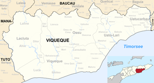
Ossu is an East Timorese administrative office ( Portuguese Posto Administrativo ) in the municipality of Viqueque . The administrative seat is in Ossu .
geography

Until 2014, the administrative offices were still referred to as sub-districts .
The administrative office of Ossu is located in the north of the municipality of Viqueque. To the west, Ossu is separated by a narrow corridor between the Viqueque administrative office and the Lacluta administrative office . Viqueque is also the southern neighbor, while the Uato-Lari administrative office is to the east . In the north, Ossu borders the municipality of Baucau . Before the 2015 territorial reform, Ossu had an area of 427.17 km². Now there are 403.66 km². The northern part of the Suco Uaibobo was given to the municipality of Baucau .
Until 2017, Ossu was divided into nine sucos : Builale ( Builalae ), Liaruca , Loi-Huno ( Loihuno , Luihuno ), Nahareca , Ossorua ( Ossoroa ), Ossu de Cima ( Ossu de Sima ), Uabubo , Uaguia ( Uagia ) and Uaibobo. In 2017 the new Suco Builo was separated from Ossorua .
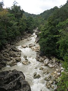
The highest mountain in the administrative office is Monte Mundo Perdido at 1763 m . Like large areas of the administrative office, it belongs to an Important Bird Area , with a number of rare bird species, but also other animals and rare orchids. Other peaks are the Laritame at 1394 m and, east of the village of Ossorua , the Builo at 1234 m . The headwaters of the Seiçal arise in the north and those of the Cuha and Tuco in the south . The annual rainfall in Ossu is 1956 mm. On the higher slopes of the mountains it is about 2500 to 3000 mm, with additional high humidity.
There are at least five caves in the vicinity of Ossu. In the Crevice of Kaisahe a colony lives of bats . The crevice extends to a depth of 30 meters, where it becomes a small, approximately 25-meter long horizontal passage that ends. The sinkhole Lunaha Mana is an eight meters wide and 18 meters deep shaft, which then leads down to more constrictions to 40 meters in depth, a larger tunnel opens, the further meanders in depth.
- Climate data
population
17,161 people live in the Ossu administrative office (2015), of which 8,472 are men and 8,689 women. The population density is 42.5 inhabitants / km². The largest language group is made up of the speakers of the national language Makasae , but Midiki , which is one of the Kawaimina languages, is also spoken in Ossu. The Midiki speakers call their language here Osomoko ( Oso Moko ). In the south one speaks the eastern tetum . The average age is 18.6 years (2010, 2004: 19.2 years).
history
Early and colonial times
Historically, the administrative office was divided into the kingdoms of Ossu and Ossorua, each ruled by a Liurai . This division was symbolized by two holy houses ( Oma-da'a ) on Mount Ossu Umurapa . One on the western and one on the eastern summit. The mountain is in the center of the administrative office.
In 1939, a mission with a small school was opened in Ossu. Here the future President Francisco Guterres also went to the St. Teresina School of the Salesians of Don Bosco between 1963 and 1969 . 1973 Guterres looked after the school for a year. The later Bishop of Dili Carlos Filipe Ximenes Belo SDB also attended the St. Teresina School.
When the Japanese occupied Timor in 1942 , the inhabitants of Ossus and Ossorua fled to the mountains. There were three local guides at the time. Dom Paulo de Freitas de Silva was the ruler of Ossorua and a descendant of the Topasse . He supported the Australian special forces that fought in guerrilla tactics against the Japanese in the Battle of Timor . On February 10, 1943, he was evacuated to Australia. Dom Francisco de Sousa e Costa (Bosi-Leki) from Ossu de Cima, like Dom Paulo, attended the missionary school. He too took part from the mountains in the war against the Japanese and the Timorese villages that supported Japan. Dom Joaquim da Costa Guterres also comes from Ossu de Cima , who initially fled to the mountains with his supporters, but then sided with Japan. The relationship between Dom Francisco and Dom Joaquim has been handed down contradictingly. Dom Joaquim is said to have been the village chief in 1938. The Portuguese post-war sources refer to him as chefe and Dom Francisco as the ruler (régulo) . The Tōru Maeda belonging to the Japanese propaganda unit in Ossu names Dom Joaquim, in contrast, as the Liurai of Ossu and Dom Francisco, only a nobleman. This could indicate a conflict over rule. On the other hand, in Timor, there is often, according to the principle of Lulik , a dual division of power, into a secular and a spiritual leader, which could have been present here. In their work, the Japanese relied on Dom Joaquim, whom they trusted to lead tens of thousands to their side.
Dom Joaquim returned to Ossu around the turn of the year 1942/43 and sealed the alliance with a meal with the Japanese agents. In return, he received a guarantee for the safety of his clan. His son Joaquim junior and his nephew Gaspar da Costa Guterres also collaborated. Further support in Ossu for Japan came from the Oliveira family, a Mestiço family that had gained influence in the colonial administration (the daughter of the Oliveiras was the mother of the future East Timorese politician Francisco Lopes da Cruz ). By the end of the war, Dom Joaquim provided tens of thousands of workers to the Japanese, delivered thousands of water buffalo, waged war against the Australian guerrillas and his children supported Japanese propaganda measures. Streets, barracks, sake factories and farms were built. A combat unit (Coluna Negra) was set up. As a reward, he was treated by the Japanese as the highest ruler of the São Domingos district (he consisted of the present-day communities of Viqueque and Baucau ).
In 1944, the Japanese propaganda unit in Ossu was replaced with a regular armed forces base and a post of the military police ( Kempeitai ) . With the help of a translator from Manado , the Kempeitai demanded that every house must assign a man for construction work. In addition, women, water buffalo and bananas were challenged. They backed up their demands with violence. Dom Joaquim and Dom Christovão, Liurai from Venilale , were tortured. Several people were executed for minor offenses. The coercive measures caused a famine in Ossu that year. When Maeda visited again, Dom Joaquim's health was badly damaged and he complained about the Kempeitai. After the Japanese surrendered, Dom Joaquim was arrested by the Portuguese colonial government. He was sentenced to life imprisonment on Atauro , where he died in 1946. Dom Francisco was rewarded for his resistance. Gaspar da Costa Guterres retained control of a small territory and became the new Liurai of Ossu in 1952. Dom Joaquim junior was evicted from the town.
Indonesian occupation and independence
From 1976 the Builo was a retreat for the FALINTIL , who fought against the Indonesian invaders. Here she founded a base de apoio , a resistance base that offered refuge for refugees from Ossu, Uato-Lari , the city of Viqueque , Uatucarbau and Baucau . In mid-1977, the Indonesian army discovered the base de apoio and attacked it. Many civilians were killed in the process. Some fled to the Matebian .
At the end of 1979 there was an Indonesian camp for East Timorese in Ossu, who should be relocated by the occupiers for better control. There were other so-called transit camps in Buanurac (Suco Loi-Huno), Builale, Cai Uai Ho O (Kaiwatu, Suco Ossu de Cima) and Loi-Huno.
In Nahareca there was an exchange of fire between FALINTIL fighters and the 745th Battalion of the Indonesian occupiers on August 10, 1983. An East Timorese was wounded and later executed by the Indonesians.
In 1983, the Indonesian governor of occupied East Timor, Mário Viegas Carrascalão, met the FALINTIL commander Xanana Gusmão for the first time for direct talks in the Lariguto valley .
Ruler of Ossu
The following list reflects the Portuguese view that Dom Francisco was the lawful liurai during WWII and not Dom Joaquim.
- Dom Pedro da Costa
- Urbano (son)
- Naha-Uru (son)
- Modo-Duu (son)
- Dom Pedro Olo-Duu (brother)
- Dom Francisco da Costa (Bosi-Leki) (around 1900–1951) (nephew)
- Gaspar da Costa Guterres / Gaspar da Silva Guterres (1952–1975; died 1996) (grandson of Dom Pedro Olo-Duu and nephew of Dom Joaquim Costa Guterres)
politics
The administrator of the administrative office is appointed by the central government in Dili. In 2014 Candido da Silva was administrator, in 2015 Rui da Costa .
economy
49% of households own coconut palms, 54% grow cassava, 52% corn, 43% rice, 42% vegetables and 18% coffee. In Loi-Huno, the Pousada de Loi-Huno is a hotel village for ecotourism.
Personalities
- Vicente da Silva Almeida (born March 7, 1972 in Darenau; † 2019), deputy director of the Faculty of Political Science at the Universidade Nasionál Timór Lorosa'e .
- Francisco Guterres (* 1954), known as Lú-Olo , President of the Republic, former President of Parliament and Chairman of FRETILIN
- Falur Rate Laek (* 1955), freedom fighter and officer
Web links
Individual evidence
- ↑ a b c d e Direcção-Geral de Estatística : Results of the 2015 census , accessed on November 23, 2016.
- ↑ Jornal da República : Diploma Ministerial no 24/2014 de 24 de Julho - Orgânica dos Postos Administrativos ( Memento of March 4, 2016 in the Internet Archive )
- ↑ a b Direcção Nacional de Estatística: 2010 Census Wall Chart (English) ( Memento from August 12, 2011 in the Internet Archive ) (PDF; 2.5 MB)
- ^ Map of the Ossu Administrative Office, Ministry of State Administration, 2015.
- ↑ Jornal da República: Diploma Ministerial n ° 16/2017 , with corrections dated May 9, 2017 , accessed on March 12, 2019.
- ^ GIS maps of Timor ( Memento from June 30, 2007 in the Internet Archive )
- ^ A b Bird life International: A lost world in Timor-Leste. Mount Mundo Perdido. A profile of its biodiversity and conservation (PDF; 755 kB)
- ↑ Fatuk-Kuak Hosi Timor Lorosa'e: Caves of Timor-Leste , pp. 32–34, accessed on January 1, 2020.
- ↑ a b Seeds of Life
- ↑ a b Direcção Nacional de Estatística: Census of Population and Housing Atlas 2004 ( Memento of November 13, 2012 in the Internet Archive ) (PDF; 14.0 MB)
- ↑ a b c d Kisho Tsuchiya: Indigenization of the Pacific War in Timor Island: A Multi-language Study of its Contexts and Impact , pp. 14-17, Journal War & Society, Vol. 38, no. February 1, 2018.
- ↑ a b Carlos Filipe Ximenes Belo : Os antigos reinos de Timor-Leste (Reys de Lorosay e Reys de Lorotoba, Coronéis e Datos) , pp. 187–190, Tipografia Diocesana Baucau 2011.
- ↑ a b "Chapter 7.3 Forced Displacement and Famine" (PDF; 1.3 MB) from the "Chega!" Report of the CAVR (English)
- ↑ "Chapter 7.2 Unlawful Killings and Enforced Disappearances" ( Memento of the original from March 25, 2016 in the Internet Archive ) Info: The archive link was inserted automatically and has not yet been checked. Please check the original and archive link according to the instructions and then remove this notice. (PDF; 2.5 MB) from the "Chega!" Report by CAVR (English)
- ↑ Diario Nacional: Morreu o ex-vice-primeiro-ministro timorense Mário Carrascalão , May 19, 2017 , accessed on May 19, 2017.
- ↑ Ministry of Staatsadministeration: Ossu , accessed on 19 June 2020th
- ↑ Ministério da Administração Estatal: Administração Municipal ( Memento of the original from June 1, 2016 in the Internet Archive ) Info: The archive link has been inserted automatically and has not yet been checked. Please check the original and archive link according to the instructions and then remove this notice.
- ↑ Direcção Nacional de Estatística: Suco Report Volume 4 (English) ( Memento of the original from April 9, 2015 in the Internet Archive ) Info: The archive link was inserted automatically and has not yet been checked. Please check the original and archive link according to the instructions and then remove this notice. (PDF; 9.8 MB)
- ^ Sydney Morning Herald, Aug. 29, 2009, East Timor's lost opportunity
- ↑ UNTL: #UNTL May 14, 2019 , accessed on May 14, 2019.
Coordinates: 8 ° 44 ′ S , 126 ° 22 ′ E


