
Loi-huno
| Loi-huno | |||

|
|||

|
|||
| Data | |||
| surface | 41.35 km² | ||
| population | 1,272 (2015) | ||
| Chefe de Suco | Miguel da Costa Melo (election 2009) |
||
| Aldeias | Population (2015) | ||
| Latu Lale | 222 | ||
| Lia Uai Oli | 212 | ||
| Samaliu | 314 | ||
| Uai-heda | 186 | ||
| Uala Uau | 338 | ||
|
|||

Loi-Huno ( Loihuno , Loi Hunu , Loihunu ) is an East Timorese place and Suco in the administrative office of Ossu ( municipality of Viqueque ).
The place

The place Loi-Huno lies on the northern border of the Sucos to the Suco Ossu de Cima , at an altitude of 326 m . In the immediate vicinity are the districts of Kailatulale , Kaitulai , Uai-Heda ( Uaiheda , Wai-Heda ) and Samaliu ( Sama Lio , Samaleo ). The Loi-Huno elementary school is located near Sama Lio. It has a partner school in Australia with Geelong College Prep Newtown . A bridge leads across the Cuha River , which forms the northern border of the Sucos here.
Loi-Huno was a stage destination and start in 2009 at the first Tour de Timor , an annual mountain bike race .
The Suco
| Loi-huno | ||
| places | position | height |
| Buanurac | 8 ° 47 ' S , 126 ° 23' E | 190 m |
| Kailatulale | 8 ° 47 ' S , 126 ° 23' E | 326 m |
| Loi-huno | 8 ° 47 ' S , 126 ° 23' E | 326 m |
| Kaitulai | 8 ° 47 ' S , 126 ° 23' E | 326 m |
| Uala Uau | 8 ° 50 ′ S , 126 ° 22 ′ E | 190 m |
| Samaliu | 8 ° 47 ' S , 126 ° 23' E | 282 m |
| Uai-heda | 8 ° 47 ' S , 126 ° 23' E | 326 m |
| Wailakurini | 8 ° 47 ' S , 126 ° 23' E | ? |

1272 inhabitants live in Loi-Huno (2015), of which 638 are men and 634 women. The population density is 30.8 inhabitants / km². There are 280 households in the Suco. 98% of the population name Makasae as their mother tongue. A small minority speaks Tetum Terik .
The Suco is located in the south of the Ossu administrative office. In the northwest, Loi-Huno borders on the Suco Ossu de Cima, in the northeast on Ossorua and in the south on the administrative office of Viqueque with the Sucos Uai-Mori in the southwest and Caraubalo in the south. The Cuha flows along the northern border. The Metaquena forms part of the border with Ossu de Cima. After the confluence of the Metaquena , the Cuha Loi-Huno crosses from north to south. Before the 2015 regional reform, Loi-Huno had an area of 73.44 km². Now there are 41.35 km². Loi-Huno gave areas in the northeast to Ossorua and in the west to Ossu de Cima. The region belongs to the Important Bird Area of the neighboring Monte Mundo Perdido .
One of the larger roads, which connects the cities of Baucau and Viqueque in a north-south direction , crosses the Suco and connects its two main settlement centers. These are Loi-Huno and its neighboring towns on the northern border and the villages of Buanurac ( Buanurak ) and Uala Uau ( Wala Wau , Walawau ) on the southern border . To the northeast of the village of Loi-Huno lies the village of Wailakurini on a side street on the banks of the Cuha . A bridge leads the country road at the border over the river. The second primary school of Sucos is located in Buanurac / Uala Uau.
In the Suco there are the five Aldeias Latu Lale , Lia Uai Oli , Samaliu , Uai-Heda and Uala Uau .
history
At the end of 1979 there was an Indonesian camp in Loi-Huno for East Timorese who were supposed to be relocated by the occupiers for better control. There were other so-called transit camps in Buanurac.
Economy and tourism
As a community project, a hotel village for ecotourism was built ( Pousada de Loi-Huno ) to strengthen the local economy. In the area around the place there are waterfalls, water holes and a network of limestone caves. A biogas power plant supplies 120 families as well as the chapel and the official building with electricity. It is run by a cooperative in the village.
Wasa-Diga , a refuge for fighters of the Forças Armadas de Libertação Nacional de Timor-Leste (FALINTIL) who fought against the Indonesian occupiers, has served as a memorial since 2017 . Between 1989 and 1996 it was used by the guerrillas for their "concentrate and disperse" tactics. Among other things, here hidden Taur Matan Ruak , Francisco Guterres and Falur rate Laek . The guerrilla group Caixa Bua Malos was responsible for the preservation and availability of the shelter.
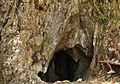
Limestone cave near Loi-Huno

In Loi-Huno's pousada
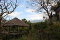
At Loi-Huno's pousada

Local knives also produced


politics
In the elections of 2004/2005 was Francisco DCG elected Chefe de Suco. In the 2009 elections , Miguel da Costa Melo won .
Personalities
- Falur Rate Laek (* 1955 in Samaliu), freedom fighter and officer
- Julieta de Jesus Panau (* 1961 in Caileleti, Samaliu), independence activist
Web links
- Results of the 2010 census for the Suco Loi-Huno ( tetum ; PDF; 8.4 MB)
- Results of the 2015 census for the Suco Loi-Huno (tetum; PDF)
- Seeds of Life: Agriculture Calendar (English)
- Seeds of Life: Suco information sheets Ossu (tetum)
Individual evidence
- ↑ a b c d Direcção-Geral de Estatística : Results of the 2015 census , accessed on November 23, 2016.
- ↑ Viqueque-Geelong Partner Schools ( Memento from May 14, 2013 in the Internet Archive )
- ↑ a b Sydney Morning Herald, Aug 29, 2009, East Timor's lost opportunity
- ↑ Fallingrain.com: Directory of Cities, Towns, and Regions in East Timor
- ↑ Results of the 2010 census for the Suco Loi-Huno ( tetum ; PDF; 8.4 MB)
- ^ Timor-Leste GIS-Portal ( Memento from June 30, 2007 in the Internet Archive )
- ↑ a b Ministry of State Administration and Territorial Management : Map of the Ossu Administrative Office ( Memento of the original dated February 4, 2016 in the Internet Archive ) Info: The archive link was inserted automatically and has not yet been checked. Please check the original and archive link according to the instructions and then remove this notice. , accessed July 21, 2017.
- ↑ Direcção Nacional de Estatística: Population Distribution by Administrative Areas Volume 2 English ( Memento from January 5, 2017 in the Internet Archive ) (Census 2010; PDF; 22.6 MB)
- ^ Bird life International: A lost world in Timor-Leste. Mount Mundo Perdido. A profile of its biodiversity and conservation (PDF; 755 kB)
- ↑ UNMIT: Timor-Leste District Atlas version 02, August 2008 ( Memento from December 3, 2011 in the Internet Archive ) (PDF; 509 kB)
- ↑ Jornal da República: Diploma Ministerial n ° 16/2017 , with corrections dated May 9, 2017 , accessed on March 12, 2019.
- ↑ "Chapter 7.3 Forced Displacement and Famine" (PDF; 1.3 MB) from the "Chega!" Report of the CAVR (English)
- ^ Government of Timor-Leste, April 3, 2010, Almost 150 families of Ponilala Village are beneficiaries and shareholders of biogas energy
- ^ Government of East Timor: Government inaugurates historic Wasa-Diga shelter , July 13, 2017 , accessed on July 21, 2017.
- ↑ Secretariado Técnico de Administração Eleitoral STAE: Eleições para Liderança Comunitária 2004/2005 - Resultados ( Memento of August 4, 2010 in the Internet Archive )
- ↑ Secretariado Técnico de Administração Eleitoral STAE: Eleições para Liderança Comunitária 2009 - Resultados ( Memento of August 4, 2010 in the Internet Archive )