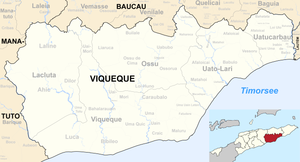
Nahareca
| Nahareca | ||

|
||
| Data | ||
| surface | 40.14 km² | |
| population | 2,030 (2015) | |
| Chefe de Suco | Paulino Albertino Ximenes (election 2009) |
|
| Aldeias | Population (2015) | |
| Darenau | 562 | |
| Macabu U | 478 | |
| Maurate | 271 | |
| Raila A | 606 | |
| Samarogo | 113 | |
|
|
||
Nahareca ( Naha Reka , Maharaca ) is an East Timorese place and Suco in the administrative office of Ossu ( municipality of Viqueque ).
The place
Nahareca is located in the center of Sucos, at an altitude of 304 m . The towns of Raila , Aelita and Samalari ( Makasae for “ banyan tree ”) also belong to the settlement center . There is a helipad for emergencies, a medical station and a primary school, the Escola Primaria Nahareca .
The Suco
| Nahareca | ||
| places | position | height |
| Aelita | 8 ° 42 ′ S , 126 ° 29 ′ E | 304 m |
| Nahareca | 8 ° 42 ′ S , 126 ° 29 ′ E | 304 m |
| Raila | 8 ° 42 ′ S , 126 ° 29 ′ E | 304 m |
| Samalari | 8 ° 42 ′ S , 126 ° 29 ′ E | 304 m |
The Suco Nahareca is located in the northeast of the Ossu administrative office. Unlike other sucos in Ossu, the borders of Nahareca didn't change noticeably. Before the 2015 regional reform, Nahareca had an area of 39.76 km². Now there are 40.14 km². To the north is the Suco Uaibobo and south of the Suco Uabubo . To the east, Nahareca borders the administrative office of Uato-Lari with its sucos Afaloicai and Macadique . The municipality of Baucau is located in the west and northeast . In the northwest it is the administrative office Venilale with its sucos Uatu Haco and Bado-Ho'o , in the northeast the administrative office Quelicai with its sucos Maluro and Lelalai . The Sauma River flows along the eastern border . The Uroassalae , which rises in Nahareca, and the Culo , the northern border river, flow into it. The rivers belong to the system of the Seiçal flowing north . The Uailequi and Dulequi rivers flow along the southeastern border with Afaloicai . They are tributaries of the south-flowing Bebuis .
2030 inhabitants live in Nahareca (2015), of which 1041 are men and 989 women. The population density is 50.6 inhabitants / km². There are 469 households in the Suco. Over 97% of the population name Makasae as their mother tongue. Minorities speak Tetum Prasa or Sa'ane .
In addition to the settlement center in the center of Sucos, there is a small town on the western border with Ossu de Cima. There is another elementary school here.
The five Aldeias Darenau , Macabu U , Maurate , Raila A and Samarogo are located in the Suco .
history
In Nahareca there was an exchange of fire between FALINTIL fighters and the 745th Battalion of the Indonesian occupiers on August 10, 1983 . An East Timorese was wounded and later executed by the Indonesians.
The later East Timorese President Taur Matan Ruak had a hiding place during his time in the resistance against the Indonesians in Nahareca, where he was supported by the local population.
politics
In the 2004/2005 elections , Paulino da Silva was elected Chefe de Suco. In the 2009 elections won Paulino Albertino Ximenes .
Web links
- Results of the 2010 census for the Suco Nahareca ( tetum ; PDF; 8.4 MB)
- Results of the 2015 census for the Suco Nahareca (tetum; PDF;)
- Seeds of Life: Suco information sheets Ossu (tetum)
Individual evidence
- ↑ a b c d Direcção-Geral de Estatística : Results of the 2015 census , accessed on November 23, 2016.
- ↑ Geoffrey Hull : The placenames of East Timor , in: Placenames Australia (ANPS): Newsletter of the Australian National Placenames Survey, June 2006, pp. 6 & 7, ( Memento of February 14, 2017 in the Internet Archive ). September 2014.
- ↑ List of polling stations for the parliamentary elections in East Timor 2007 (PDF file; 118 kB)
- ↑ a b UNMIT: Timor-Leste District Atlas version 02, August 2008 ( Memento from December 3, 2011 in the Internet Archive ) (PDF; 509 kB)
- ↑ Fallingrain.com: Directory of Cities, Towns, and Regions in East Timor
- ↑ Direcção Nacional de Estatística: Population Distribution by Administrative Areas Volume 2 English ( Memento from January 5, 2017 in the Internet Archive ) (Census 2010; PDF; 22.6 MB)
- ^ Timor-Leste GIS-Portal ( Memento from June 30, 2007 in the Internet Archive )
- ↑ Results of the 2010 census for the Suco Nahareca ( tetum ; PDF; 8.4 MB)
- ↑ Jornal da Républica with the Diploma Ministerial n. 199/09 ( Memento of February 3, 2010 in the Internet Archive ) (Portuguese; PDF; 323 kB)
- ↑ "Chapter 7.2 Unlawful Killings and Enforced Disappearances" (PDF; 2.5 MB) from the "Chega!" Report of the CAVR (English)
- ↑ Radio Timor-Leste: TMR congratulates people of Ossu Sub District , August 28, 2013
- ↑ Secretariado Técnico de Administração Eleitoral STAE: Eleições para Liderança Comunitária 2004/2005 - Resultados ( Memento of August 4, 2010 in the Internet Archive )
- ↑ Secretariado Técnico de Administração Eleitoral STAE: Eleições para Liderança Comunitária 2009 - Resultados ( Memento of August 4, 2010 in the Internet Archive )
