
Mönchsroth
| coat of arms | Germany map | |
|---|---|---|

|
Coordinates: 49 ° 1 ' N , 10 ° 22' E |
|
| Basic data | ||
| State : | Bavaria | |
| Administrative region : | Middle Franconia | |
| County : | Ansbach | |
| Management Community : | Wilburgstetten | |
| Height : | 441 m above sea level NHN | |
| Area : | 11.92 km 2 | |
| Residents: | 1604 (Dec. 31, 2019) | |
| Population density : | 135 inhabitants per km 2 | |
| Postal code : | 91614 | |
| Area code : | 09853 | |
| License plate : | AN , DKB, FEU, ROT | |
| Community key : | 09 5 71 179 | |
| LOCODE : | DE MCS | |
| Community structure: | 6 parts of the community | |
| Address of the municipal administration: |
Main street 2 91614 Mönchsroth |
|
| Website : | ||
| Mayoress : | Edith Stumpf (Free Citizen List) | |
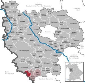
| Location of the community Mönchsroth in the district of Ansbach | ||
  |
||

Mönchsroth is a municipality in the Central Franconian district of Ansbach and a member of the Wilburgstetten administrative community .
geography
Geographical location
The community lies exactly on the state border with Baden-Württemberg . The district of Mönchsroth is traversed by the Rotach, a tributary of the Wörnitz . Neighboring communities are (clockwise from the north): Dinkelsbühl , Wilburgstetten , Stödtlen and Wört .
Community structure
The political municipality Mönchsroth has six officially named parts of the municipality (the type of settlement is given in brackets ):
- Diederstetten ( village )
- Fall mastery ( wasteland )
- Hammer forge (wasteland)
- Hasselbach (village)
- Mönchsroth ( parish village )
- Winnetten (village)
history
The place was first mentioned in the 12th century as "Rotha". The document also mentions a “preposituramque Rothe”, which means the Benedictine monastery Mönchsroth founded around 1130 . In 1286 the place was first called "Mvnchrôte", in 1350 "Muenchrot", and finally in 1604 "Mönchsrodt". The place name is derived from the name of the Rotach (= red river), where the place is located.
With the community edict (early 19th century), the rural community Mönchsroth was formed. It was subordinate to the Mönchsroth Lordship Court in terms of administration and jurisdiction . In 1961 the municipality had an area of 6.937 km².
Incorporations
On January 1, 1971, Diederstetten was incorporated in the course of the regional reform.
Population development
In the period from 1988 to 2018, the population increased from 1305 to 1580 by 275 inhabitants or 21.1%.
Mönchsroth community
| year | 1818 | 1840 | 1852 | 1861 | 1867 | 1871 | 1875 | 1880 | 1885 | 1890 | 1895 | 1900 | 1905 | 1910 | 1919 | 1925 | 1933 | 1939 | 1946 | 1950 | 1961 | 1970 | 1987 | 2005 | 2011 | 2016 |
|---|---|---|---|---|---|---|---|---|---|---|---|---|---|---|---|---|---|---|---|---|---|---|---|---|---|---|
| Residents | 808 | 940 | 976 | 1008 | 981 | 1054 | 1060 | 992 | 1002 | 887 | 869 | 845 | 824 | 830 | 794 | 782 | 715 | 654 | 928 | 908 | 764 | 890 | 1286 | 1621 | 1605 | 1584 |
| Houses | 175 | 171 | 185 | 197 | 193 | 183 | 198 | 364 | 486 | 497 | ||||||||||||||||
| source |
Part of the municipality Mönchsroth
| year | 1818 | 1861 | 1871 | 1885 | 1900 | 1925 | 1950 | 1961 | 1970 | 1987 |
|---|---|---|---|---|---|---|---|---|---|---|
| Residents | 808 | 1008 | 1054 | 1002 | 824 | 768 | 897 | 759 | 877 | 1093 * |
| Houses | 175 | 171 | 185 | 192 | 190 | 180 | 196 | 324 * | ||
| source |
politics

mayor
The teacher Edith Stumpf (Free Citizens List) has been the mayor since February 1, 2012. She was elected as the successor to Fritz Franke (SPD) on November 13, 2011 and was confirmed in office on November 5, 2017 with an opposing candidate with 68.5% of the votes.
Municipal council
After the local elections on March 2, 2008 , the local council has twelve members, all of whom belong to the Free Voting Group . The turnout was 56.2%. Another member and chairman of the municipal council is the mayor.
coat of arms
The description of the coat of arms reads: By lowered golden bars divided by blue and red, at the top a silver eagle holding a transverse golden abbot's staff in its claws, at the bottom a silver St. Andrew's cross.
Culture and sights

Buildings
- Limesturm (replica)
- Former monastery church of the Benedictine provostry of St. Peter and Paul
- Former synagogue from 1761 (Rathausstrasse 1). A comprehensive Genisafound was recovered here in 1988 and is now in the Jewish Museum Franken Fürth / Schnaittach.
Architectural monuments
Soil monuments
traffic
The state road / state road 2385 runs through Mönchsroth east to Wilburgstetten to federal road 25 or west via Regelsweiler to Wört . The district road AN 46 / K 3211 runs south to Eck am Berg . Communal roads run north to Diederstetten , west to Gaxhardt and southeast to Wittenbach .
sons and daughters of the town
- Johann Leonhard Dober (1706–1766), missionary
- Georg Friedrich Benecke (1762–1844), philologist
- Christian Daniel Benecke (1768–1851), businessman, senator and mayor of Hamburg
- Abraham Kohn (1819–1871), co-founder and president of the Kehillat Anshe Ma'ariv Jewish community in Chicago
Personalities who have worked in the place
- Georg Bickel (1862–1924), painter pastor
literature
- August Gebeßler : City and district of Dinkelsbühl (= Bavarian art monuments . Volume 15 ). Deutscher Kunstverlag, Munich 1962, DNB 451450930 , p. 167-173 .
- Gunther Reese: Jewish Mönchsroth. Invitation to a tour. Haigerloch 2006. ISBN 3-933231-36-1
- Wolf-Armin von Reitzenstein : Lexicon of Franconian place names. Origin and meaning . Upper Franconia, Middle Franconia, Lower Franconia. CH Beck, Munich 2009, ISBN 978-3-406-59131-0 , p. 151 .
- Anton Steichele (Ed.): The diocese Augsburg historically and statistically described . tape 3 . Schmiedsche Verlagbuchhandlung, Augsburg 1872, p. 476-493 ( digitized version ).
- Pleikard Joseph Stumpf : Mönchsroth . In: Bavaria: a geographical-statistical-historical handbook of the kingdom; for the Bavarian people . Second part. Munich 1853, p. 703 ( digitized version ).
Web links
- Map of the municipality of Mönchsroth on the BayernAtlas
- Entry on the coat of arms of Mönchsroth in the database of the House of Bavarian History
Individual evidence
- ↑ "Data 2" sheet, Statistical Report A1200C 202041 Population of the municipalities, districts and administrative districts 1st quarter 2020 (population based on the 2011 census) ( help ).
- ^ Community Mönchsroth in the local database of the Bavarian State Library Online . Bayerische Staatsbibliothek, accessed on September 17, 2019.
- ↑ W.-A. v. Reitzenstein, p. 151.
- ^ Address and statistical manual for the Rezatkreis in the Kingdom of Baiern . Buchdruckerei Chancellery, Ansbach 1820, p. 77 ( digitized version ).
- ↑ a b c Bavarian State Statistical Office (ed.): Official city directory for Bavaria, territorial status on October 1, 1964 with statistical information from the 1961 census . Issue 260 of the articles on Bavaria's statistics. Munich 1964, DNB 453660959 , Section II, Sp. 763 ( digitized version ).
- ^ Wilhelm Volkert (ed.): Handbook of Bavarian offices, communities and courts 1799–1980 . CH Beck, Munich 1983, ISBN 3-406-09669-7 , p. 448 .
- ↑ a b Only inhabited houses are given. In 1818 these were designated as fireplaces , in 1840, in 1852 as houses , and from 1871 to 2016 as residential buildings.
- ↑ a b Alphabetical index of all the localities contained in the Rezatkreise according to its constitution by the newest organization: with indication of a. the tax districts, b. Judicial Districts, c. Rent offices in which they are located, then several other statistical notes . Ansbach 1818, p. 60 ( digitized version ).
- ↑ a b c d e f g h i j k l m Bavarian State Statistical Office (Hrsg.): Historical municipality register: The population of the municipalities of Bavaria from 1840 to 1952 (= contributions to Statistics Bavaria . Issue 192). Munich 1954, DNB 451478568 , p. 168 , urn : nbn: de: bvb: 12-bsb00066439-3 ( digitized ).
- ↑ a b Joseph Heyberger, Chr. Schmitt, v. Wachter: Topographical-statistical manual of the Kingdom of Bavaria with an alphabetical local dictionary . In: K. Bayer. Statistical Bureau (Ed.): Bavaria. Regional and folklore of the Kingdom of Bavaria . tape 5 . Literary and artistic establishment of the JG Cotta'schen Buchhandlung, Munich 1867, Sp. 1001 , urn : nbn: de: bvb: 12-bsb10374496-4 ( digitized version ).
- ↑ a b Kgl. Statistical Bureau (ed.): Complete list of localities of the Kingdom of Bavaria. According to districts, administrative districts, court districts and municipalities, including parish, school and post office affiliation ... with an alphabetical general register containing the population according to the results of the census of December 1, 1875 . Adolf Ackermann, Munich 1877, 2nd section (population figures from 1871, cattle figures from 1873), Sp. 1167 , urn : nbn: de: bvb: 12-bsb00052489-4 ( digital copy ).
- ↑ a b K. Bayer. Statistical Bureau (Ed.): Localities directory of the Kingdom of Bavaria. According to government districts, administrative districts, ... then with an alphabetical register of locations, including the property and the responsible administrative district for each location. LIV. Issue of the contributions to the statistics of the Kingdom of Bavaria. Munich 1888, Section III, Sp. 1099 ( digitized version ).
- ↑ a b K. Bayer. Statistical Bureau (Ed.): Directory of localities of the Kingdom of Bavaria, with alphabetical register of places . LXV. Issue of the contributions to the statistics of the Kingdom of Bavaria. Munich 1904, Section II, Sp. 1164 ( digitized version ).
- ↑ a b Bavarian State Statistical Office (ed.): Localities directory for the Free State of Bavaria according to the census of June 16, 1925 and the territorial status of January 1, 1928 . Issue 109 of the articles on Bavaria's statistics. Munich 1928, Section II, Sp. 1201 ( digitized version ).
- ↑ a b Bavarian State Statistical Office (ed.): Official place directory for Bavaria - edited on the basis of the census of September 13, 1950 . Issue 169 of the articles on Bavaria's statistics. Munich 1952, DNB 453660975 , Section II, Sp. 1038 ( digitized version ).
- ↑ a b Bavarian State Statistical Office (Hrsg.): Official local directory for Bavaria . Issue 335 of the articles on Bavaria's statistics. Munich 1973, DNB 740801384 , p. 170 ( digitized version ).
- ↑ a b Bavarian State Office for Statistics and Data Processing (Ed.): Official local directory for Bavaria, territorial status: May 25, 1987 . Issue 450 of the articles on Bavaria's statistics. Munich November 1991, DNB 94240937X , p. 329 ( digitized version ).
- ↑ a b Mönchsroth: Official statistics of the LfStat

Adelshofen | Arberg | Aurach | Bechhofen | Bruckberg | Book at the forest | Burgoberbach | Burk | Colmberg | Dentlein am Forst | Diebach | Dietenhofen | Dinkelsbühl | Dombühl | Dürrwangen | Ehingen | Feuchtwangen | Flachslanden | Gebsattel | Gerolfingen | Geslau | Heilsbronn | Herrieden | Insingen | Langfurth | Lehrberg | Leutershausen | Lichtenau | Merkendorf | Mitteleschenbach | Mönchsroth | Neuendettelsau | Neusitz | Oberdachstetten | Ohrbach | Ornbau | Petersaurach | Röckingen | Rothenburg ob der Tauber | Rügland | Saxony near Ansbach | Schillingsfürst | Schnelldorf | Schopfloch | Steinsfeld | Unterschwaningen | Wassertrüdingen | Weidenbach | Weihenzell | Weiltingen | Wettringen | Wieseth | Wilburgstetten | Windelsbach | Windsbach | Wittelshofen | Wolframs-Eschenbach | Wörnitz
Unregulated areas:
Lower Forest