
Nuno-Mogue
| Nuno-Mogue | |||

|
|||

|
|||
| Data | |||
| surface | 31.93 km² | ||
| population | 4,175 (2015) | ||
| Chefe de Suco | Hilario da CB Soares (election 2016) |
||
| Aldeias | Population (2015) | ||
| Hatu-Builico | 1,583 | ||
| Hato-Seraquei | 247 | ||
| Laqueco | 241 | ||
| Lebulau | 735 | ||
| Mausoromata | 106 | ||
| Nuno-Mogue-Lau | 413 | ||
| Queorema | 206 | ||
| Tucaro | 644 | ||
|
|||

Nuno-Mogue ( Nuno Mogue , Nunu Mogue , Nonomogue ) is an East Timorese place in Suco Nuno-Mogue . The Suco belongs to the Hatu-Builico administrative office ( municipality of Ainaro ).
The place
Nuno-Mogue is located in the southern tip of the Sucos at an altitude of 938 m between the Belulik rivers and the Gourete which flows into it . There is a primary school in the village. The country road from Ainaro to Dili crosses the Gourete on a bridge .
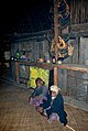
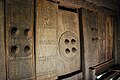
On April 22, 2010 a traditional, holy house ( Lulik Lokometa-Darlau Nunufu ) was inaugurated. The reconstruction is part of a joint project between the Secretary of State for Culture and the American Embassy to restore holy houses in different parts of the country. The aim was to keep the traditional architecture as part of the local culture. The round hut stands on stilts. The interior is located under the thatched roof and can be reached via a ladder made of tree trunks.
- Holy House of Nuno-Mogue


The Suco
| Nuno-Mogue | ||
| places | position | height |
| Hato-Seraquei | 8 ° 58 ′ S , 125 ° 32 ′ E | ? |
| Hatu-Builico | 8 ° 54 ' S , 125 ° 31' E | 2155 m |
| Lebulau | 8 ° 56 ′ S , 125 ° 32 ′ E | 1226 m |
| Leobutu | 8 ° 57 ′ S , 125 ° 32 ′ E | 1116 m |
| Mausoromata | 8 ° 53 ′ S , 125 ° 31 ′ E | 2155 m |
| Morocali | 8 ° 55 ′ S , 125 ° 32 ′ E | ? |
| Nuno-Mogue | 8 ° 58 ′ S , 125 ° 31 ′ E | 938 m |
| Nuno-Mogue-Lau | 8 ° 57 ′ S , 125 ° 32 ′ E | 1125 m |
| Tucarocoiloco | 8 ° 57 ′ S , 125 ° 31 ′ E | 1259 m |


4175 people live in the Suco (2015), of which 2093 are men and 2082 women. The population density is 130.8 inhabitants / km². There are 654 households in the Suco. Over 55% of the population name Mambai as their mother tongue. Over 40% speak Tetum Prasa .
Before the 2015 territorial reform, Nuno-Mogue had an area of 33.48 km². Now there are 31.93 km². The eastern border to Suco Mulo is largely formed by the Telemau river , the entire south-eastern border to Suco Mauchiga by the Belulik river and part of the south-western border to Suco Manutaci ( Ainaro administrative office ) by the Gourete river. In the north lies the Suco Liurai (administrative office Maubisse ), in the west the Suco Baboi Leten (administrative office Atsabe ) and in the northwest the Suco Catrai Caraic (administrative office Letefoho ). The last two belong to the municipality of Ermera . The Tiris Dikomali waterfall is located near Nuno-Mogue .
The largest town is Hatu-Builico , the main town of the administrative office, in the north of the Sucos. It is 2155 m above sea level, making it the highest and also the coldest place in the country. From here, within two and a half hours, the easiest route leads to Tatamailau ( 2963 m ), East Timor's highest mountain. The towns of Mausoromata ( Mausoro-Mata , Mausoro Mata ) and Queorudo are in the immediate vicinity of Hatu-Builico . The latter is already in the Sucos Mulo area, on the other side of the Telemau.
The country road from Ainaro to Dili runs parallel to the Belulik through the southwest of the Sucos. The places Nuno-Mogue, Hato-Seraquei ( Hatu-Seraquei , Hato Seraq ), Nuno-Mogue-Lau ( Nunu-Mogue Lau , Nonomoguelao ), Leobutu and Lebulau ( Lebu-Lau , Lepulau ) are located on it. Here the road leaves the Suco over a bridge over the Telemau. North of the road is the place Tucarocoiloco ( Tukarocoiloco ). The village of Morocali is located on the middle course of the Telemaus . In addition to the primary school in Nuno-Mogue, there are also primary schools in Hatu-Builico, Tucarocoiloco and Lebulau. There is also a medical post and a permanent helipad in Hatu-Builico.
In Nuno-Mogue there are the eight Aldeias Hatu-Builico ( Hato-Builico ), Hato-Seraquei , Laqueco ( Laquico ), Lebulau , Mausoromata , Nuno-Mogue-Lau , Queorema and Tucaro . According to official sources, Aldeia Queorema also belongs to Nuno-Mogue, but maps show the place in neighboring Mulo.
history
After bad harvests in 2006, the region experienced a food shortage.
politics
In the 2004/2005 elections , António Menezes Lopes was elected Chefe de Suco and confirmed in his post in 2009. In the 2016 elections , Hilario da CB Soares won .
Web links
- Results of the 2010 census for the Suco Nuno-Mogue ( tetum ; PDF file; 7.82 MB)
- Results of the 2015 census for the Suco Nuno-Mogue (tetum; PDF)
- Seeds of Life: Suco information sheets Hatu-Builico (tetum)
Individual evidence
- ↑ a b c d Direcção-Geral de Estatística : Results of the 2015 census , accessed on November 23, 2016.
- ↑ a b UNMIT: Timor-Leste District Atlas version 02, August 2008 ( Memento of the original dated December 3, 2011 in the Internet Archive ) Info: The archive link was inserted automatically and has not yet been checked. Please check the original and archive link according to the instructions and then remove this notice. (PDF file; 570 kB)
- ↑ Timor-Leste Gouvernment, April 22, 2010, Inauguration of Sacred House of Suco of Nunu Moge, on the district of Ainaro
- ↑ Fallingrain.com: Directory of Cities, Towns, and Regions in East Timor
- ↑ Results of the 2010 census for the Suco Nuno-Mogue ( tetum ; PDF file; 7.82 MB)
- ↑ Direcção Nacional de Estatística: Population Distribution by Administrative Areas Volume 2 English ( Memento of the original from January 5, 2017 in the Internet Archive ) Info: The archive link has been inserted automatically and has not yet been checked. Please check the original and archive link according to the instructions and then remove this notice. (2010 census; PDF; 22.6 MB)
- ↑ Konstantin Vilkov: Tiris Dikomali waterfall near Nunumoge, Ainaro. , accessed April 20, 2017.
- ↑ a b Timor-Leste GIS Portal ( Memento from June 30, 2007 in the Internet Archive )
- ↑ Jornal da Républica with the Diploma Ministerial n. 199/09 ( Memento of February 3, 2010 in the Internet Archive ) (Portuguese; PDF file; 315 kB)
- ↑ Secretariado Técnico de Administração Eleitoral STAE: Eleições para Liderança Comunitária 2004/2005 - Resultados ( Memento of August 4, 2010 in the Internet Archive )
- ↑ Secretariado Técnico de Administração Eleitoral STAE: Eleições para Liderança Comunitária 2009 - Resultados ( Memento of August 4, 2010 in the Internet Archive )
- ↑ Jornal da República: Lista Naran Xefe Suku Eleito 2016 , December 2, 2016 , accessed on June 17, 2020.
![]() Map with all coordinates: OSM | WikiMap
Map with all coordinates: OSM | WikiMap
The administrative borders within East Timor changed in 2015. This article must therefore be checked and updated if necessary. See New Administrative Boundaries .