
Nuthe glacial valley
| coat of arms | Germany map | |
|---|---|---|

|
Coordinates: 52 ° 7 ' N , 13 ° 15' E |
|
| Basic data | ||
| State : | Brandenburg | |
| County : | Teltow-Fläming | |
| Height : | 43 m above sea level NHN | |
| Area : | 341.31 km 2 | |
| Residents: | 6564 (Dec. 31, 2019) | |
| Population density : | 19 inhabitants per km 2 | |
| Postal code : | 14947 | |
| Primaries : | 03371, 033732 (Berkenbrück, Hennickendorf, Nettgendorf), 033733 (Dümde, Holbeck, Lynow, Schönefeld, Stülpe) | |
| License plate : | TF | |
| Community key : | 12 0 72 312 | |
| LOCODE : | DE NML | |
| Community structure: | 23 districts | |
| Address of the municipal administration: |
Frankenfelder Straße 10 14947 Nuthe-Urstromtal |
|
| Website : | ||
| Mayor : | Stefan Scheddin | |
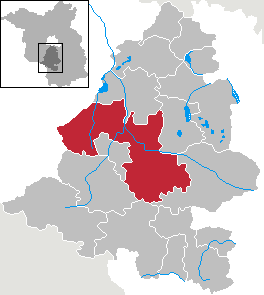
| Location of the municipality of Nuthe-Urstromtal in the Teltow-Fläming district | ||
  |
||

Nuthe-Urstromtal is a municipality in the Teltow-Fläming district in Brandenburg . With an area of 341.31 km² Nuthe-Urstromtal is the largest municipality in Germany without municipal rights.
geography
The community is located to the west and east of the 101 federal highway between Trebbin, Luckenwalde and Jüterbog. The municipality is named after the Nuthe river and the Baruther glacial valley , which formed in the last Ice Age and separates the northern plates of Zauche and Teltow from the southern Fläming .
With 341.31 km² it is the largest municipality without municipal rights in Germany. The sparsely populated community does not have a grown historical center, but when it was formed in 1993 it was based on the natural-geographic boundaries between the cities of Trebbin , Luckenwalde , Jüterbog and Baruth .
geology
Southeastern glacial / Fläming part
In the uninhabited Flemming Meadows in the glacial valley, the ice reached its maximum southern extent. The community villages run parallel to the valley on its north and south edges. The villages on the southern border of the valley lie below the Niedere Fläming, some of which is part of the municipality. The Golmbergzug , part of the Stülpe district , with 178 meters, the highest elevation of the Lower Fläming, is interpreted as part of the Werbig-Petkuser-Staffel as a terminal moraine from the Saale Ice Age. The difference in altitude between the mountain and the glacial valley is around 120 meters over a distance of only 1 kilometer. This makes it one of the areas with the highest relief energy in Brandenburg. From some unwooded hilltops, there is a broad view to the north - in particularly clear weather as far as Berlin and Potsdam (more than 60 kilometers). The Golmberg and the Jänickendorfer Heide to the west on the Fläminghöhe border the municipality to the south.
Northwestern part of the groove
14 of the 23 villages and around two fifths of the north-western area are in the Nuthe-Nieplitz Nature Park . The characteristics of the nature park with fields, orchards , rolling hills, flocks of sheep , wet meadows , luchen , moors , water mills and natural ash trees also shape the landscape of the entire community, as well as dense coniferous and mixed forests . In the upper course of the Pfefferfließ , the nature reserve Oberes Pfefferfließ has been designated since 2003, which aims to preserve the strongly meandering stream in the long term. The new lakes that have formed on the lower reaches of the river near Stangenhagen when the pumping stations were switched off since 1991 and lead to a renaturation of the moor, extend as far as the community.
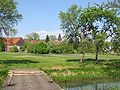
View from Hammerfließ to Schönefeld
View from Pekenberg to Nettgendorf

Aerial view of Kemnitz

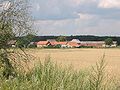
Aerial view of Gottsdorf
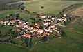
Aerial photo of Liebätz


Community structure
According to its main statute, the community consists of 23 districts:
There are also the following living spaces
|
|
|
|
|
The municipal administration is based in Ruhlsdorf.
history

On May 20, 1992, the Minister of the Interior gave his approval for the establishment of the Nuthe-Urstromtal office, initially based in the non-official city of Luckenwalde . The formation came about with the publication of the notice on June 15, 1992. When it was founded, the office initially comprised 20 communities: Berkenbrück, Dobbrikow, Dümde, Felgentreu, Frankenförde, Gottow, Hennickendorf, Holbeck, Jänickendorf, Kemnitz, Lynow , Märtensmühle, Nettgendorf, Ruhlsdorf, Scharfenbrück, Schönefeld, Schöneweide, Stülpe, Woltersdorf and Zülichendorf .
On December 6, 1993 the 20 communities merged to form the new Nuthe-Urstromtal community. At the same time, the Nuthe-Urstromtal office was dissolved, and the new municipality became an office-free. Ahrensdorf and Liebätz, districts of the municipality of Märtensmühle before the merger, became independent districts within the new municipality.
Since the community was only formed in 1993, there is no common history, rather the history of these villages was shaped by the towns of Jüterbog , Luckenwalde and above all by the Zinna monastery . In 1285 and 1307 some of the villages that belonged to Luckenwalde at that time were sold together with Luckenwalde to the Cistercian monastery Zinna. The monks noted in the official inheritance book of the Zinna monastery (the mentioned village of Melne no longer exists):
In 1307 we bought half of the length of the Strasbourg swamp with the five villages Dobbrichow, Netkendorf, Hentkendorf, Melne and Mertensmohle from a Heinrich von Trebbin, lord in Blankensee.

Stories about a Marienkapelle and a treasure entwine around the Golmberg, which lies on the district of Stülpe (see on this and also on the following Golmberg ). The preserved castle in Stülpe is connected to the Brandenburg nobility family Rochow , which was one of the most influential families in the Middle Ages, especially in the Zauche . The builder of the baroque building was Adam Ernst von Rochow in 1754. A castle, which the Magdeburg archbishop had built to secure a passage through the swampy glacial valley, stood very likely in the 12th century . In the middle of the 15th century, the castle passed into the possession of the von Schlieben knights, before Hans von Hake from the equally influential von Hake family , who mainly lived in Kleinmachnow , acquired the ground and walls in Stülpe in 1537 , until 1648 the Rochows left.
During the National Socialist era , a satellite camp of the Luckau prison was set up in Felgentreu for up to 60 prisoners. During the Second World War , Soviet prisoners of war from " Main Camp III A " were also interned in a barbed wire barn and forced to work in the fields. In the external command, a resistance group of 75 people called “ Aktion Rote Faust ” had formed, which was organized by Georg Makurat and Wilhelm Mayer. In 1980, a memorial plaque was attached to his house at Dobbrikow 27 , reminding him that “the center of the international resistance group 'Aktion Rote Faust' was located here”.
Between 1936 and 1941, the Ahrensdorf Landwerk was a training facility for the Hachshara movement , where young Jewish people were prepared for their emigration to Palestine . North-east of the town's exit on Löwendorfer Straße , a memorial plaque has been commemorating 48 young people murdered in the Shoah since 1997 .
In the Hennickendorf district, the Wilhelm-Leuschner barracks of the Bundeswehr existed until September 2007 , where the 6th and 7th / Repair Battalion 410 were most recently stationed.
Population development
|
|
|
Territory of the respective year, number of inhabitants: as of December 31, from 2011 based on the 2011 census
politics
Community representation
The community council consists of 18 community representatives and the full-time mayor. The local election on May 26, 2019 resulted in the following distribution of seats:
| Party / group of voters | Seats |
|---|---|
| AfD | 3 |
| Voting group together for Nuthe-Urstromtal (GNU) | 3 |
| CDU | 2 |
| The left | 2 |
| SPD | 2 |
| Free List of Non-Party Members (FLP) | 2 |
| Community of Independent Voters (GUW) | 1 |
| Alliance 90 / The Greens | 1 |
| FDP | 1 |
| Single applicant Diana Zabel | 1 |
mayor
- 2001–2009: Winand Jansen (SPD)
- 2009–2017: Monika Nestler (Die Linke)
- since 2017: Stefan Scheddin (independent)
Nestler was elected mayor of the community on September 27, 2009. Scheddin was elected in the mayoral election on October 15, 2017 with 50.8% of the valid votes for a term of eight years.
coat of arms
|
|
Blazon : "Divided obliquely to the left by a lowered wave cut, above a black half-timbered house with 23 golden compartments in silver over an oblique left blue wave bar, below in green a golden ear after the division."
The coat of arms was approved on September 12, 1994. |
| Justification of the coat of arms: The coat of arms of the municipality as well as its name indicate two main geographical parts. The blue band stands for the north-western area in the lowlands around the Nuthe , while the lower green part with the ear of corn symbolizes agriculture in the south-eastern part, which is largely characterized by the grassland of the Flemmingwiesen in the Baruther glacial valley . The upper part of the coat of arms symbolizes a so-called Spiekerhus or Nuthe-Nieplitz house , typical of the Brandenburg region , as it has been preserved in the village of Kemnitz, for example. |
Sights and culture
In the list of architectural monuments in Nuthe-Urstromtal and in the list of ground monuments in Nuthe-Urstromtal are the cultural monuments entered in the list of monuments of the state of Brandenburg.
Buildings
- Ahrensdorf: memorial stele for the Hachschara site. In the hunting lodge Ahrensdorf Jewish youths were to emigrate to 1936-1941 Palestine prepared.
- Dümde: The village church of Dümde is a half-timbered church from 1793, to which a steeple was added in 1881. The equipment comes from the construction period.
- Dobbrikow: The church was built between 1184 and 1194 as a feudal secular building with a chapel and was only dedicated to the church in the 15th century. It is made of field stone, while the extension and the sacristy were made with masonry bricks in the 19th century, which clearly stand out from the rest of the building. The half-timbered tower was built around 1700. Inside there is an altar from 1648, a pulpit from 1679 and an offering box from the 16th century.
- Gottsdorf: Obermühle, Klinkenmühle, both on the Pfefferfließ (see there)
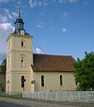
- Jänickendorf: The Jänickendorf village church was built between 1833 and 1835 in a round arch style . In the 1960s, the church furnishings were largely replaced.
- Kemnitz: the last so-called Nuthe-Nieplitz-Haus (formerly also Spiekerhus ) typical for this Brandenburg region has been preserved and renovated. It is a middle - floor house made of half-timbered , but supplemented by a passable arbor over the entire width of the ground floor zone of the gable or by a small lateral porch also on the gable side. This porch was initially used as a storage facility. (see image).
- Ruhlsdorf: The Ruhlsdorf village church is a neo-Gothic brick building from 1904. Inside there is a period of construction equipment.
- Schöneweide: The Schöneweide village church was built in 1753 and burned down in 1945 during the Second World War. In 1954 the parish had the building restored. The church furnishings are uniformly modern. A harmonium from the Swedish harmonium factory Olof Lindholm from the 1920s is on the gallery .
- Stülpe: Stülpe manor house and Stülpe village church , originally built in 1562. On the north side of the church, an epitaph says that Rochus von Rochow (* February 9, 1797 - December 6, 1819), his grandmother Juliane Eleonore (* March 15, 1734 - November 6, 1806), b. von Voss, who married Adam Ernst von Rochow in 1752, and her second husband Gottlieb Ludwig von Beville (* July 28, 1734, † April 9, 1810) are resting. The castle in Stülpe was built in 1754 for Adam Ernst von Rochow.
- Wolterdorf: The village church Woltersdorf was built in 1911 from reddish brick in the neo-Gothic style. In the interior there is a church furnishings from the period of construction.
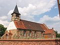
Church in Dobbrikow

Stülpe Castle
Church in Stülpe
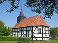
Half-timbered church from 1793 in Dümde
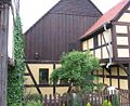
Nuthe-Nieplitz house in Kemnitz


Natural monuments
- Hennickendorf: Foundling Ewald .
museum
The Oskar Barnack Museum is located in Lynow and is reminiscent of the precision mechanic and head of development at the Leitz company in Wetzlar , who was born here in 1879 . Barnack developed the 35mm camera ; the first Leica ( Leitz Camera ) came onto the market in 1925.
Economy and Infrastructure
In addition to traditional agriculture , with the natural environment and the proximity to Berlin, tourism has recently become more and more important for the region. The now heavily frequented Flaeming skate not only led to an upswing in the catering and accommodation industry, but also in the transport industry and in the area of guided tours.
The administration of the Nuthe-Nieplitz Nature Park is based in the Dobbrikow district.
traffic
The federal road 101 crosses the municipality between Trebbin and Luckenwalde .
The following state roads connect the districts with each other:
- L 70 between Sperenberg and Petkus
- L 73 between Michendorf and Baruth
- L 80 between Buchholz and Luckenwalde
The Woltersdorf / Nuthe-Urstromtal stop is on the Berlin – Halle railway line and is served by the RE 3 Stralsund – Berlin – Falkenberg (Elster) regional express line . The Zossen – Jüterbog railway line with the former Schönefeld and Jänickendorf stops has been closed since 1996 and 1998, respectively.
In the local public transport , the municipality is served by the transport company Teltow-Fläming with several bus routes and since spring 2010 with an on- call bus.
education
There are two primary schools in the municipality:
- Elementary school Stülpe
- Primary school "Am Pekenberg" Zülichendorf
Flaeming-Skate and FlämingWalk
In 2004, twelve Nordic walking courses and a beginners' route were set up in the nature park with the FlämingWalk , which touch several districts of the community. Kemnitz forms a starting point for all routes, the mill route and vineyard path, for example, lead through Nettgendorf. The Flaeming-Skate ("the" Flaeming-Skate officially), which is reserved for inline skating and cycling, leads both with its main course and with secondary courses through parts of the municipality, through the Flemmingwiesen and over the Golmberg. The route on largely paved and three-meter-wide paths is the largest continuous route of its kind with 190 kilometers on several circuits.
Sons and daughters of the church
- Oskar Barnack (1879–1936), inventor of the 35 mm miniature camera (Leica), born in Lynow
- Klaus Drichert (* 1938), European and GDR champion in motorboat racing, born in Dobbrikow
- Rudi Dutschke (1940–1979), sociologist and student leader, born in Schönefeld
- Paul Pribbernow (* 1947), cartoonist, born in Holbeck
- Hans Wichard von Rochow (1898–1945), Canon of Brandenburg, born in Stülpe
literature
- Christa and Johannes Jankowiak: On the way to Nuthe and Nieplitz. Portrait of a Brandenburg landscape. On old tracks and new paths . Stapp Verlag Berlin, 1995 ISBN 3-87776-061-9 (the quote from the Zinna office inheritance book is taken here)
- Jan Feustel, Between watermills and swamp forests, A travel and adventure guide to the Baruther Urstromtal , Hendrik Bäßler Verlag, Berlin 1999 ISBN 3-930388-11-1 , on Stülpe Castle see pages 67ff
Web links
- Homepage of the community
- Hachschara site Ahrensdorf
- Nature park administration
- Homepage of Liebätz
- Gottow in the RBB program Landschleicher on April 3, 2005
Individual evidence
- ↑ Population in the State of Brandenburg according to municipalities, offices and municipalities not subject to official registration on December 31, 2019 (XLSX file; 223 KB) (updated official population figures) ( help on this ).
- ↑ Main statutes of the Nuthe-Urstromtal community from December 15, 2010 (PDF; 41 kB)
- ^ Service portal of the state administration Brandenburg. Nuthe-Urstromtal community
- ^ Formation of the Niedergörsdorf office. Announcement of the Minister of the Interior of May 13, 1992. Official Gazette for Brandenburg - Joint Ministerial Gazette for the State of Brandenburg, Volume 3, Number 38, June 15, 1992, p. 744.
- ^ Community of Nuthe-Urstromtal
- ↑ Historical municipality register of the state of Brandenburg 1875 to 2005. District Teltow-Fläming . Pp. 26-29
- ↑ Population in the state of Brandenburg from 1991 to 2017 according to independent cities, districts and municipalities , Table 7
- ^ Office for Statistics Berlin-Brandenburg (Ed.): Statistical report AI 7, A II 3, A III 3. Population development and population status in the state of Brandenburg (respective editions of the month of December)
- ^ Result of the local election on May 26, 2019
- ↑ Local elections October 26, 2003. Mayoral elections , p. 33
- ↑ Brandenburg Local Election Act, Section 74
- ^ Result of the mayoral election on October 15, 2017
- ↑ Coat of arms information on the service portal of the state administration of Brandenburg
- ↑ Coordinates of the memorial stele for the Hachshara site 52 ° 11 ′ 53.5 ″ N , 13 ° 10 ′ 44.3 ″ E
- ↑ Schools in Nuthe-Urstromtal