Oestrich (Erkelenz)
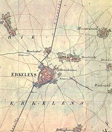
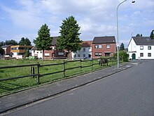
Oestrich is a partly still rural district of Erkelenz in the district of Heinsberg in North Rhine-Westphalia . Until the middle of the 20th century, the place was a village in the northeast in front of the city. Due to the progressive urban development, it has now merged into the core city. To the north of Oestrich there is a large new residential area called Oestricher Kamp .
location
The Ziegelweiherpark and the Old Cemetery on Brückstrasse form the western boundary between Oestrich and the city . The oldest village street is today's Oestricher Straße, there is also the Kaiser Karl chapel. Here, as well as on Brückstrasse, there are still a few former farms .
history
Less distant from the site, prehistoric and Roman excavations were made north to south-east . In one of Emperor Otto the Great confirmed exchange deed of 17 January 966 between the Marienstift to Aachen and the Lorraine Counts Realty He will then together with Erkelenz ( herclinze ) and other localities than that in Mühlgau in the county of Eremfred preferred site host rich called. The Marienstift was now the owner of all the land in Oestrich as well as in Erkelenz, which it assigned as man and interest goods according to the feudal rights that arose in Franconian times . The counts exercised the rule of the country.
A list of interest from the monastery from the 12th century gives 31 interest goods, 5 mills and 4 manors for Oestrich . In Erkelenz, according to the same directory, there were 32 interest goods, 1 brewery and 5 mansions, so that both places appear to be equal at this time. This also allows the conclusion that Oestrich could ultimately be older than Erkelenz. The network of trails on old maps also suggests that the Cologne Heerweg originally ran through Oestrich. Likewise, the Bellinghovener mill, which was only demolished around 1905, was not located from Erkelenz, but only seen from Oestrich in the direction of Bellinghoven . And not from Erkelenz, but of Oestrich from in which led to their chroniclers Mathias Baux mentioned in the 16th century "old Belling Hovener way" (today Mühlenfeld) over after Bellinghoven.

However, the individual possessions of the monastery were not all within the respective local limits, but in the vicinity. The hamlets and villages in the vicinity of Erkelenz and Oestrich arose from them, the names of which indicate that they began in bush and forest areas. After listing the various manors in the surrounding villages, the chronicler reports that the manor in Oestrich, called the Gut zu den Linden , is a manor that Maess (Mathias) received from Etgenbusch as a fief and is now owned by Konrad von Oestrich is located. The Marienstift zu Aachen received the tenth part of the income from all the lands, which consisted of money as well as natural goods that had to be delivered to the mayor or rent master and stored in the tithe barn , which was originally also located in Oestrich.
When Count Rainald II of Geldern raised the town of Erkelenz, which was by now certainly not unfortified, to a town, the surrounding villages formed a unified legal and administrative district with it in the Geldrian glory of Erkelenz. The rural population enjoyed the same civil rights as the townspeople and, in the event of danger, had the right to take their movable property into the protection of the city walls , but also the duty to help defend the city. In addition to the city mayor , it also elected the country mayor from among its ranks, both of whom were at the forefront of the city administration .
As the closest village to the city, Oestrich shared its eventful history in a special way. Much war people moved through the country, which was a Geldrische exclave in Jülichen , burned, murdered and extorted money for property, life and limb. The bridge gate, which was built in 1355 as the first gate of the city, at last a mighty gate castle , led over the Kölner Heerweg to Oestrich and provided the support of the population fleeing into the city in case of danger.
In 1423 Junker Scheiffart von Merode burned down almost all of Oerath , Buscherhof and Wockerath in an arc around the city from northwest to east . They were also in Kückhoven and finally tried to get to Oestrich, because whoever had Oestrich in hand could storm the bridge gate on a straight path. Before Oestrich, however, they encountered violent resistance from Duke Arnold von Geldern and finally withdrew defeated.
In the vicinity of today's brick pond, on the so-called Karle, a chapel was built in 1452 in honor of Charlemagne, who, according to folklore, is said to have rested on a stone while hunting.
In 1580 and 1581, a plague epidemic struck the country and claimed 458 lives in the town and parish of Erkelenz. In 1676, 200 people died here within two months of Rotlauf .
After the dead had been buried in the city and from the surrounding villages at and in the parish church of Erkelenz since time immemorial, the cemetery on Brückstrasse, which is now called the Old Cemetery and below , was laid in 1825 halfway between Erkelenz and Oestrich Monument protection stands.
In 1844 the chapel on the Karle was demolished and rebuilt in the middle of the village. In the chapel there are terracotta figures of the 14 emergency helpers , which come from the 18th century and from an altar in the parish church of Erkelenz, as well as a squat figure of Charlemagne. On the other hand, a valuable figure of St. Andrew , now in the parish church, comes from the old Oestrich chapel. There are two large stones by the chapel, one of which is decorated with flowers by the local population.
In 1854 Oestrich had 48 houses and 275 inhabitants. In 1903 it was connected to the public water supply from the nearby water tower together with Erkelenz . This was followed by the public sewer system and, in 1909, the supply of electricity from the municipal power station, which is also nearby .
On 16 January 1945 the third of four major flew air raids of World War II, Allied bombers , the now largely evacuated the city in two successive waves. The first wave was in the Oestrich and Buscherhof area. A direct bombing hit a house on the corner of Brückstrasse / Mühlenfeld down to the ground and killed several people in this house. More bombs fell at the old cemetery and claimed more lives.
On February 26, 1945, Oestrich and Erkelenz were captured by American soldiers of the 102nd Infantry Division of the 9th US Army in the course of Operation Grenade . The few residents who remained in Oestrich who had not been evacuated were taken to Kückhoven, where they had to stay for two weeks. Houses in Oestrich were looted immediately before and after the end of the war.
Although the first development outside the city walls of Erkelenz in the direction of Oestrich along today's Brückstraße had already taken place around 1600, the place only closed up to the city after the Second World War. North of the village is in the two decades around the turn of the millennium the residential area Oestricher Kamp with kindergarten , primary school emerged and some stores of basic services. Some of the streets in this residential area bear the names of the Celtic people of the Eburones , who resided in this country, and the Frankish ruling families of Merovingians and Carolingians, as well as some of their kings .
Place name
The place name 'hostrich', as it was written in the first documentary mention in 966, is of Celtic - Franconian origin. The vowel O was pronounced long, which is why it was later written after the failed H with an elongation E 'Oe ...'. This part of the word 'host' has an Indo-European root. The Latin 'hostis' means stranger, enemy. The word can also be found in English 'host' (with a long pronounced vowel) and means host. Likewise, in French , where the accent circumflex (^) indicates a long accent and a fancy S, the 'hôte' is a guest, host and the 'hôtel' is a hostel . In the Franconian language of the 5th and 6th centuries, 'hôst' denotes a fortified farmstead as a stage station for the army . One was 'in hoste', that is on a campaign .
The second word component '... rich' in the place name also has an Indo-European root. In Latin the 'rex' is a king, lord, leader and in Celtic it is the 'rix'. In Old English 'rice' means powerful, wealthy. In Germanic it is called 'rîk' and in Old High German 'rîh'. The following determiner (... rich) is not used in the Germanic, but in the Celtic and Romance languages.
So the place name 'hostrich' referred to a sovereign army base , an 'army mountain'. This interpretation is supported by the fact that a permanent castle was built later . But not in Oestrich, but in Erkelenz, not far from Cologne's Heerweg - a military day's march (about 30 km) from Roermond , the main town of the later Upper District of Geldern , to which Erkelenz and its surrounding villages belonged.
religion
The majority of the population is Catholic. Oestrich has always been part of the parish of St. Lambertus in Erkelenz.
Culture and sights
Attractions
- Kaiser Karl Chapel. It is the only church in the Diocese of Aachen and the Archdiocese of Cologne that is consecrated to Charlemagne.
societies
- Village community of Oestrich
Personalities
- Leo Heinrichs (born August 15, 1867 in Oestrich, † February 23, 1908 in Denver ( Colorado )), Father in the Franciscan Order , shot by an anarchist in Denver in 1908 during Holy Mass . A beatification process has started. The Leo-Heinrichs-Weg in the village is named after the clergyman.
- Josef Gaspers (* 1886 in Oestrich, † 1959 in Gangelt ) was a Catholic priest, provost in Heinsberg and local researcher. In 1958 he became an honorary citizen of the city of Heinsberg.
literature
- Jac. Offermann, history of cities, towns, villages, castles, etc. Monasteries in the districts of Jülich, Düren, Erkelenz, Geilenkirchen and Heinsberg , Linnich 1854
- Mathias Baux u. a., The chronicle of the city of Erkelenz in: Annals of the historical association for the Lower Rhine, issue 5, page 47, Cologne 1857
- Josef Gaspers, Leo Sels u. a., History of the City of Erkelenz , Erkelenz 1926
- Josef Lennartz, When Erkelenz sank into ruins , City of Erkelenz 1975
- Dorfgemeinschaft Oestrich (ed.), The Karlskapelle in Oestrich , Erkelenz 1984
- Ulrich Eisenhardt, German legal history , Verlag CH Beck, Munich 2004, ISBN 3-406-51996-2
Individual evidence
- ↑ Cf. Peter Paul Schweitzer, Altdeutscher Wortschatz , Hadamar 2002 ( Memento of the original from November 9, 2011 in the Internet Archive ) Info: The archive link was inserted automatically and has not yet been checked. Please check the original and archive link according to the instructions and then remove this notice. with the appropriate interpretation of similar place names, pages 132 f
Web links
- Website of the city of Erkelenz
- Monuments in the city of Erkelenz
- Churches and chapels in the city of Erkelenz
Coordinates: 51 ° 5 ′ N , 6 ° 20 ′ E


