
Vettelschoss
| coat of arms | Germany map | |
|---|---|---|

|
Coordinates: 50 ° 37 ' N , 7 ° 21' E |
|
| Basic data | ||
| State : | Rhineland-Palatinate | |
| County : | Neuwied | |
| Association municipality : | Linz on the Rhine | |
| Height : | 300 m above sea level NHN | |
| Area : | 6.91 km 2 | |
| Residents: | 3607 (Dec. 31, 2019) | |
| Population density : | 522 inhabitants per km 2 | |
| Postal code : | 53560 | |
| Area code : | 02645 | |
| License plate : | NO | |
| Community key : | 07 1 38 075 | |
| Association administration address: | Am Schoppbüchel 5 53545 Linz am Rhein |
|
| Website : | ||
| Local Mayor : | Heinrich Freidel ( CDU ) | |
| Location of the local community Vettelschoss in the Neuwied district | ||
  |
||

.jpg)

Vettelschoss is a municipality in the Neuwied district in Rhineland-Palatinate . It belongs to the Verbandsgemeinde Linz am Rhein , which has its administrative headquarters in the city of Linz am Rhein .
geography
Vettelschoss is at an altitude of about 300 m above sea level. NHN , 7 km northeast of the city of Linz am Rhein and 9 km southeast of the city of Bad Honnef and extends on the edge of the Asbach plateau in the western foothills of the Westerwald . The Willscheider Berg rises to the west ( 360 m above sea level ) with its basalt lake. The municipality of Vettelschoss encompasses an area sloping from west to east and is between 190 and 365 m above sea level. NHN . The highest point is reached on the Rheinwesterwälder volcanic ridge above Kalenborn , the lowest in the valley of the Seelbach near Oberelsaff . 25 km of hiking trails run within the wooded and strongly reliefed landscape of the municipality, which is located in the Rhine-Westerwald nature park . You can reach the Rheinsteig via two hiking trails marked with a yellow symbol in the direction of Rheinbreitbach and in the direction of Erpel .
Community structure
The districts of Kalenborn , Kau , Willscheid and Oberwillscheid as well as the residential areas Klaushof, Seiferhof and Willscheiderberg belong to Vettelschoss . In addition, a southeastern part of Kretzhaus (city of Linz am Rhein) belongs to Vettelschoss as part of the municipality. Furthermore, in the vicinity of the Seelbach, in the Oberelsaff district belonging to Neustadt (Wied) , there are two more houses and a chapel, which also belong to the Vettelschoss municipality as part of Oberelsaff .
Expansion of the municipal area
In the west, the municipal boundary runs largely on Landesstrasse 254. The Erpeler Bach and Hallerbach brooks in the north of Vettelschoss and the Seelbach in the south are largely natural borders . In 1974 and 1993, respectively, there were area corrections, which led to a part of the Reifstein corridor (near the forester's house of the same name) that was formerly part of the local community Erpel and is now part of Vettelschoss.
Neighboring communities
In the south, the municipality of Sankt Katharinen borders on Vettelschoss with its districts Notscheid and Homscheid. In the west, the local community shares the border with the city of Linz am Rhein, on whose boundary the Kretzhaus, which is adjacent to the Vettelschoss district of Kalenborn, is located. Other neighboring communities are Erpel in the north-west, Windhagen in the north and east and Neustadt (Wied) in the south-east, although there is only a very short border to the latter.
history
Grave finds in the Walhelde corridor between Vettelschoss and Oberelsaff prove that the Vettelschoss municipality was already settled before Christianity. In the 1930s the Rhenish Provincial Administration in Bonn investigated ring walls on the Hummelsberg and Asberg mountains, which are located near the town . They are attributable to the Hunsrück-Eifel culture and were established in the period from 600 to 400 BC. Were erected. The ramparts were destroyed by the basalt mining.
The place name probably comes from the late early Middle Ages . The last syllable in the 9th century was probably Sciotz , 960 Scoz , which in Old High German denotes the gable end of a building, actually a protection-giving lead. Vettel is related to the Gothic fatha , Middle High German vade or fade for fence or partition. According to this, Vettelschoss could mean something like "enclosure that lies on the protected side of the Willscheider mountain". According to another interpretation of the name, Vettel is derived from the Old High German personal name Wetilo , which is synonymous with bailiwick or pawn contract. The parish registers of Neustadt an der Wied also contain the spellings Feddelschoss, Fettelschoss and Vetelschoss for Vettelschoss.
The field names Beielsberg and Beielswiese even Bilsberg , Bilswiese , Bilstein meadow written, could be on Bilstein Cunegonde point. Their daughter Hedwig von Gudensberg bequeathed her Rhenish possessions to her husband Ludwig around 1100 , including those that later belonged to the Vettelschoss in Altenwied . The mentioned field names could therefore indicate a settlement around 1100.
The first documentary mention of the place comes from a will from May 25, 1344, in which a Cristina de Vertilschos (= Christine von Vettelschoss ) - an inclusive in Dattenberg - bequeathed her possessions to various people and monasteries.
Other documents in which people from Vettelschoss are named come from the years 1418, 1434 and 1540.


17th to 19th century
In the 17th century Vettelschoss belonged to the parish of Neustadt in the Altenwied office, the Altenwied office belonged to the Electorate of Cologne . Vettelschoß formed the so-called. The second part of the Honnschaft Lorscheid. On the order of Archbishop Maximilian Heinrich von Bayern , an inventory of all honors in the Altenwied office was carried out in 1660. The following were listed for the Vettelschosser honors :
- In Seiffen (Seiferhof) one, in Calenborn (Kalenborn) and Hambscheid (Homscheid) two each, in Stroeth (Strödt) five and in Vettelschoss eleven houses, one of which was unoccupied. In Wilscheid (Willscheid) there were three houses, in Oberwilscheid the Obristhof and the Untersten Hof, in Mittelwilscheid one farm. Lorscheidt (Lorscheid) had five houses, in Hinterlorscheidt there was only one house. In Noscheid (Notscheid) and Hilkerscheid all the houses had disappeared, there were only meadows there. Some of the places and living spaces mentioned here belong to the local parish of St. Katharinen today .
The rule of Kurköln ended in 1803 after more than 500 years with the Reichsdeputationshauptschluss . The Electorate of Cologne area in this region was initially the Wied-Runkel assigned and came in 1806 due to the Act of Confederation, the Duchy of Nassau . Lohrscheid II was then subordinate to the administration of the Nassau office of Altenwied . After the treaties concluded at the Congress of Vienna , the area was ceded to the Kingdom of Prussia in 1815 .
Vettelschoss was a municipality in the then newly formed civil registry district Neuwied (from 1848 district Neuwied ) in the administrative district of Koblenz and initially from 1817 to 1823 by the mayor's office Altenwied , then by the mayor's office Neustadt (Wied) (from 1927 Neustadt office ). The municipality of Vettelschoss corresponded to the former Lohrscheid II community without Notscheid . In 1892 Vettelschoss got its own postal agency, the delivery area of which also included the localities of the former municipality of Rederscheid and a large part of the municipality of Elsaffhal .
20th century
Basalt mining and processing used to be important in economic terms . 1921 sold Vettelschoß the land in the district Kalenborn for the construction of basalt work to melt basalt-Aktien-Gesellschaft (today Kalenborn Kalprotect ) in Linz am Rhein. With this money, the community was able to finance the connection to the electricity grid in 1922 and 1923 .
On 7 November 1970, the local community as part of Rhineland-Palatinate was administrative and territorial reform of the dissolved association of municipalities (up to October 1, 1968 Office ) Neustadt (Wied) assigned to the municipality of Linz am Rhein.
In the 1970s, Vettelschoss was the headquarters of the Streif Haus group of companies, which also produced Neckermann prefabricated houses with 4,000 employees in 8 plants. Today the headquarters of Streif GmbH is in Weinsheim .
Population development
The development of the population of Vettelschoss, the values from 1871 to 1987 are based on censuses:
|
|
religion
The Michael's church in Vettelschoss, which was built in 1975 and consecrated in 1977, and the branch church in Kalenborn belong to the Catholic parish of St. Michael Vettelschoss. The Evangelical Church is represented by the Johanneskirche, which was built in 1967 together with the parish and rectory.
politics
Municipal council
The municipal council consists of 20 elected council members, who were elected in a personalized proportional representation in the local elections on May 26, 2019 , and the local mayor .
The distribution of seats in the municipal council:
| choice | SPD | CDU | FWG | FDP | total |
|---|---|---|---|---|---|
| 2019 | 4th | 8th | 7th | 1 | 20 seats |
| 2014 | 5 | 9 | 6th | - | 20 seats |
| 2009 | 5 | 11 | 4th | - | 20 seats |
| 2004 | 5 | 12 | 3 | - | 20 seats |
- FWG = Free Voting Group Vettelschoss / Kalenborn e. V.
mayor
The honorary local mayor is Heinrich Freidel (CDU), he was directly elected in the 2014 local elections with 67.5 percent of the vote and replaced Falk Schneider in this office. In the direct election on May 26, 2019, he was confirmed in his office for another five years with a share of the vote of 55.01%.
coat of arms
The Vettelschoss coat of arms has been in official use since 1983. The flame sword stands for the Archangel Michael , the horseshoe symbolizes the earlier importance of agriculture for the place and the basalt columns symbolize mining and the successor industry.
Culture and sights
Attractions

former observation tower on Willscheider Berg

Lookout point Wäller Blick

Landmark from 1680

Antonius Chapel near Oberelsaff
Village museum in its current state


- Blue lake
- The Blue Lake was created from one of the three basalt quarries in the local area. Basalt was mined here until around 1940, today it is a popular travel destination as a natural lake with a campsite and a restaurant.
- Willscheider Berg
- To the west of the center of Vettelschoss, the Willscheider Berg rises to a height of 360 m above sea level today . NHN , originally 370 m. Basalt was mined here until 1974. The area around the Willscheider Berg has been designated as a biotope complex and, since 1999, as a compensatory or compensation area for an industrial area that has developed in the south.
- Willscheider mountain lake
- After its closure, the basalt quarry created a lake that is about 50 m below today's plateau. The lake is inaccessible due to the almost vertically sloping rock walls and is therefore a retreat and development area for the flora and fauna.
- Viewpoint "Wäller Blick"
- On the spoil dump of the former Willscheider Berg quarry and the current biotope complex, the Vettelschosser Heinzelmännchen created a lookout point that is well worth seeing. Here you can look across the district of Vettelschoss in good weather to the high Westerwald - hence the name: Wäller Blick. The lookout point can be reached barrier-free via forest paths. There are plenty of free parking spaces at the nearby Willscheider Berg clubhouse. Well usable as a starting point for long hikes. There is a lot to discover around the Willscheider Berg. Here u. a. Relaxation and relaxation benches were built for those seeking relaxation.
- Landmark from 1680
- In the district of Kalenborn there is a boundary stone from 1680, which marked the border between the offices and parishes of Linz, Neustadt and Erpel. Today the city of Linz on the Rhine and the local communities of Vettelschoss and Erpel meet here.
- Bernardus Chapel
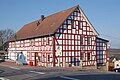
- The Bernardus Chapel from 1683 is probably on the site of an older chapel, as a chapel for the place was mentioned in a document from 1570. It is the only half-timbered chapel within the Linz am Rhein community and the only cultural monument of the Vettelschoss community:
- Anthony's Chapel
- The Antoniuskapelle is located above the town of Oberelsaff, which belongs to Neustadt (Wied), in the municipality of Vettelschoss. The interior contains a neo-Gothic altar that comes from the Anna monastery in Remagen.
- Schmitzhof
- The oldest surviving half-timbered house in Vettelschoss was built around 1640 and was owned by the St. Katharinen monastery until 1803 . It takes its name from the previous owners. The community bought the house and has been using it as a village museum since 2010. In order to make the museum more attractive, a wine bar was opened in the building (unfortunately closed as of 05/2020). In addition, a small and fine Christmas market has been taking place in and around the aahle Schmitzhoff on the 1st Sunday in Advent for several years.
Regular events

- Fair in Vettelschoss: on the first weekend in October
- Fair in Kalenborn: on the last weekend in May
- Carnival parade : on Carnival Sunday
- Christmas market at the village museum: on the first Sunday in Advent
Economy and Infrastructure
Established businesses
Kalenborn Kalprotect , which was founded in 1921 to manufacture cast basalt and is now one of the world's leading manufacturers in the field of universal wear protection, is based in the district of Kalenborn .
The Willscheider Berg industrial park is a location of the shoe manufacturer Birkenstock . The company relocated its headquarters from Bad Honnef to Vettelschoss in 1998, after opening a newly built distribution warehouse here in 1997. At the beginning of 2014, the administration was moved from Vettelschoß to Neustadt (Wied) , while Vettelschoss continues to serve as the company's logistics center.
Public facilities

- The parish office with council chamber in Erlenweg 3 is the seat of the local parish.
- In the field of education, Vettelschoss has a primary school as well as a kindergarten and a day care center .
- The community-owned Willscheider Berg clubhouse is located near the crater lake and, like the Kalenborn community hall, can be rented for all kinds of events.
- The volunteer fire brigade , founded on May 1, 1899, consists of around 30 members and moved into a new fire station in 2002 .
traffic
To the west of the community runs the federal highway 42 , which leads from Koblenz to Bonn . The next motorway junctions are Bad Honnef / Linz on the Rhine and Neustadt / Wied on the federal motorway 3 .
In 1912, the Linz (Rhine) –Flammersfeld railway was opened and had two stations in the municipality ( Kalenborn and Vettelschoss ). Today only the section between Linz and Kalenborn, where tourist traffic takes place, still exists.
Personalities
- Egidius Schneider (1893–1958), social advisor and adult educator, born in Vettelschoss
- Astrid van Nahl (* 1951), German Scandinavian mediaevalist , journalist and translator , has lived in Vettelschoß for a long time
Web links
- Vettelschoss parish
- Vettelschoss on the website of the Verbandsgemeinde Linz am Rhein
- History of basalt mining in Vettelschoss (PDF file; 953 kB)
Individual evidence
- ↑ a b State Statistical Office of Rhineland-Palatinate - population status 2019, districts, municipalities, association communities ( help on this ).
- ↑ State Statistical Office Rhineland-Palatinate (ed.): Official directory of the municipalities and parts of the municipality. Status: January 2019 [ Version 2020 is available. ] . S. 50 (PDF; 3 MB).
- ↑ HH Mohr: Field names are signposts in the local history (Vettelschoss)
- ↑ Elli Lind: Historical chronicle of Vettelschoss and its districts. 1988, p. 9; there on “Josef Hoffmann: Land on the Wied. 1930, p. 185 ”.
- ↑ Elli Lind: Historical chronicle of Vettelschoss and its districts. 1988; there on “Gerhard Mürkens: The place names of the Ahrweiler district. 1959, p. 55 “.
- ↑ Elli Lind: Historical chronicle of Vettelschoss and its districts. 1988, p. 10; There reproduction of the document from the main state archive in Koblenz.
- ^ Nassauische Annalen: Jahrbuch des Verein für Nassauische Altertumskunde und Geschichtsforschung, Volume 9-10 , 1868, p. 305
- ^ Theo Winterscheid: From the history of the post in the Windhagener area. In: Windhagen - A home book. Economica Verlag, Bonn 1994, p. 112.
- ↑ State Statistical Office Rhineland-Palatinate - regional data
- ^ The State Returning Officer Rhineland-Palatinate: City Council Election 2019 Vettelschoss. Retrieved February 20, 2020 .
- ^ The Regional Returning Officer Rhineland-Palatinate: Municipal elections 2014, city and municipal council elections.
- ↑ The Regional Returning Officer for Rhineland-Palatinate: Local elections 2014, election of the honorary local and city mayors
- ↑ The Regional Returning Officer Rhineland-Palatinate: direct elections 2019. Accessed on February 20, 2020 (see Linz am Rhein, Verbandsgemeinde, sixth row of results).
- ^ From a loose association to a group , Bonner Rundschau, October 15, 2013
- ↑ http://www.feuerwehr-vettelschoss.de/

Cities: Bad Hönningen | Dierdorf | Linz on the Rhine | Neuwied | Uncle . Municipalities: Anhausen | Asbach | Bonefeld | Breitscheid (Westerwald) | Bruchhausen | Buchholz (Westerwald) | Dattenberg | Datzeroth | Dernbach | Döttesfeld | Dry wood | Ehlscheid | Drake | Oath of May | Hammerstein (on the Rhine) | Hanroth | Hardert | Harschbach | Hausen (Wied) | Hümmerich | Isenburg (Westerwald) | Kasbach-Ohlenberg | Kleinmaischeid | Kurtscheid | Leubsdorf (on the Rhine) | Leutesdorf | Linkenbach | Marienhausen | Meinborn | Melsbach | Neustadt (Wied) | Niederbreitbach | Niederhofen | Niederwambach | Oberdreis | Oberhonnefeld-Gierend | Upper wheels | Ockenfels | Puderbach | Ratzert | Raubach | Rengsdorf | Rheinbreitbach | Rheinbrohl | Rodenbach near Puderbach | Rossbach (Wied) | Rüscheid | Saint Catherine | Stebach | Steimel | Street house | Thalhausen | Urbach (Westerwald) | Vettelschoss | Waldbreitbach | Windhagen | Woldert .