
Waco
| Waco | |
|---|---|
| Nickname : Heart of Texas | |
 Praetorian Building on Franklin Avenue |
|
 flag |
|
| Location in Texas | |
 |
|
| Basic data | |
| Foundation : | 1849 |
| State : | United States |
| State : | Texas |
| County : | McLennan County |
| Coordinates : | 31 ° 33 ′ N , 97 ° 9 ′ W |
| Time zone : | Central ( UTC − 6 / −5 ) |
|
Inhabitants : - Metropolitan Area : |
136,436 (as of 2017) 265,207 (as of 2016) |
| Population density : | 625.6 inhabitants per km 2 |
| Area : | 247.4 km 2 (approx. 96 mi 2 ) of which 218.1 km 2 (approx. 84 mi 2 ) are land |
| Height : | 143.3 m |
| Postcodes : | 76700-76799 |
| Area code : | +1 254 |
| FIPS : | 48-76000 |
| GNIS ID : | 1370701 |
| Website : | www.waco-texas.com |
| Mayor : | Kyle Deaver |
Waco is the district capital and the county seat of McLennan County in the US state of Texas . The city, founded in 1849, has around 136,500 inhabitants (as of 2017) and is located in central Texas on the southern edge of the Great Plains . The city has traditionally been a cattle breeding center; in the 1920s it was an essential field of activity for the Ku Klux Klan . The city administration tackled the consequences of the Great Depression and the associated desertification of the city center with a revitalization program at the end of the 1950s. Waco made international headlines in 1993 when it was forcibly stormed the grounds of the Davidian sect, on which almost 100 members of the group had barricaded themselves for weeks.
geography
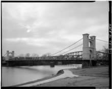
Geographically, Waco is on the edge of the southern Great Plains , whose flat, poorly forested landscape characterizes the wider area around the city. The city lies on both sides of the Brazos River, which leads to the southeast and flows into the Gulf of Mexico . The core area of the city lies on the western bank of the river; The most important connection between the western and eastern parts is the Waco Suspension Bridge, built in 1870 . Immediately to the west, Waco borders Lake Waco, a reservoir that is fed by the Bosque River which flows into the Brazos.
In terms of location, the city is the dominant center of McLennan County. The urban agglomeration includes the cities of China Spring, Lacy-Lakeview , Bellmead , Robinson , Hewitt , Woodway as well as the Beverley Hills enclave (which has the status of an independent city ) on the edge of the inner city. Within Texas, Waco is part of the Central Texas region, which is still heavily influenced by cattle breeding , the endpoints of which are roughly defined by the metropolises of Dallas , Fort Worth and Austin . Because of its location near the geographic center of the state, Waco is also nicknamed the "Heart of Texas".
The urban area is divided into the districts of North Waco (core urban area), Brook Oaks, the actual city center (Downtown), University, Brookview, Heart of Texas, Parkdale Viking Hills, Mountain View and Carver. on the eastern side of the Brazos River. In addition, the rough division into center, north side, south side, east side and outskirts is common. In terms of traffic, several national connecting routes intersect in Waco: Interstate Highway 35 (north-south direction), US highways 84 and 77 (east-west direction or north-south direction), State Highway 6 and the railway lines of the Missouri Pacific Railroad and the St. Louis Southwestern Railway .
The weather in Waco is determined by the vast landscape of the Great Plains. Hot summers are characteristic ; the winter fall due to the southern location of not as cold as in more northern prairie -Bundesstaaten. Due to the open location, not protected by mountains, steady wind is typical. In addition, Waco is located in " Tornado Alley " - the corridor from Texas to Minnesota with particularly frequent tornadoes .
The climatic average is between about 1 ° C and 13 ° C in January and 23 ° C and 36 ° C in August. The rainfall is between 42 mm in January and 116 mm in May. The number of rainy days per month is between 4 and 5 and is therefore rather low.
|
Monthly average temperatures and rainfall for Waco, Texas
|
|||||||||||||||||||||||||||||||||||||||||||||||||||||||||||||||||||||||||||||||||||||||||||||||||||||||||
history
19th century


In the pre-Columbian historical period , the area in which the city of Waco later emerged was located in the catchment area of the Mississippi culture - an Indian high culture that stretched on both sides of the Mississippi and bordered the woodland culture in the east and the pueblo culture in the west . In the 17th and 18th centuries , the area was inhabited by the Wichita , a smaller tribe on the eastern edge of the Great Plains. In the north and west it bordered the Comancheria - the domain of the Comanches , who dominated the southern prairies as a tribe. Around 1830 the settlement structure of the area changed - on the one hand due to the influx of Cherokee Indians, who were driven from their settlement areas in Alabama and Georgia on the Path of Tears , and on the other hand due to the advance of Texan settlers . First European settlement on the terrain was a Texas Rangers outpost , which was founded in 1837.
The actual settlement began at the end of the 1840s. The city was founded by George B. Erath , a co-founder of the Ranger. The city's name was derived from the Huaco, an indigenous tribe who had previously lived in the area; It was formally founded as a city in 1849.
After the formation of McLennan County in 1850, Waco was designated as the administrative seat. The population grew rapidly. In 1859 it comprised 749 inhabitants; by 1870 it had grown to over 3,000. Economically, cotton cultivation and the associated plantation economy dominated . During the US Civil War , townspeople were actively involved in the Confederation cause . Six Confederate generals were from the city; A total of 17 companies of soldiers fought on the great battlefields of the civil war. Economically, the area was drained by the war. Slave emancipation and the policy of reconstruction after 1865 ensured a rapid increase in local forces, which opposed this development. Violent attacks against members of the Afro-American population group were the order of the day. In the decades following the Civil War, Waco developed into a center of Texan cattle breeding. The city was on the Chisholm Trail ; the number of cattle herded through them ranged from 600,000 to 700,000 by 1871. In addition, Waco advanced to become an alternative location for new settlers who intended to settle in Texas. During the 1870s, the city had saloons , playhouses and its own red light district . The prostitution was until the beginning of the 20th century under public supervision. Because of the violent atmosphere, the city was nicknamed "Six Shooter Junction".
In the early 1880s, Waco became a railway hub . As early as 1866, the outskirts were the site of an ambitious infrastructure project - the Waco Suspension Bridge, which spanned the Brazos River and was completed in 1870. With a mean span of 145 m, the Suspension Bridge was the longest suspension bridge west of the Mississippi at the time . It simplified the cattle drive on the Chisholm Trail and served the operating consortium as a lucrative source of income until it was taken over by the county in 1889 and shortly thereafter by the city. Waco experienced a further appreciation when Baylor University, founded in Independence , moved to the city in 1886. Due to the influx of educational institutions , the city received another additional designation at the end of the 19th century : "Athens of Texas". Paved streets, an electric overland railway with a connection to Dallas, city parks, a first gas system and trams were added as further infrastructure parts. In addition, different industries had settled in the city by the turn of the century : iron foundries , boiler plants, flour mills and cotton spinning mills . By 1914, Waco had become an important center of the insurance industry ; the population was around 35,000 at the time.
20th and 21st centuries

.jpg)

During the First World War , Waco was the location of Camp MacArthur - an infantry training base in the northwest of the city. The 35,000 soldiers who were stationed there between 1917 and 1919 temporarily doubled the city's population. Added to this was the increased influx of African Americans from the surrounding districts - an influx that was motivated by the hope of better jobs , more wages and access to social advancement . Although the majority of the colored people who were brought in remained poor, a black middle class slowly established itself in the 1920s . In the 1910s and 1920s, violence exploded in a series of assaults and lynchings . A tragic climax of this development was the public assassination of the 16-year-old African American Jesse Washington , who was lynched on May 15, 1916 in front of a crowd of hundreds. The background to this development was the resurgence of the Ku Klux Klan, which had a strong base in central Texas and had an offshoot with the local group code number 33 in Waco. The author Patricia Ward Wallace stated in retrospect that it was above all black prosperity that fueled white racism and promoted a climate in which cultured whites not only joined the clan, but also actively participated in lynch mobs. In 1923 more than 2,000 Klansmen marched through the city. Looking back in 2010, an article author for the Texas State Historical Association stated that this development was implicitly tolerated by a large part of the local elite at the time.
The Great Depression of the 1930s halted the city's economic dynamism. Farmers , ranchers and factories shut down or shut down their production. State New Deal programs tried to break the trend with job creation measures and state infrastructure projects. In addition, a distribution center for surplus goods was set up in Waco. The Second World War brought about a renewed economic upswing. In 1942, Waco was the leading manufacturer of cots , tents and mattresses . The defense industry also opened up greater employment opportunities to women. On May 11, 1953, a hurricane devastated the city. He killed 114 people, seriously injured 145 and completely destroyed 196 commercial buildings. In the longer term, the tornado caused many businesses to move to the outskirts and contributed to the decline of the inner-city business districts. Another economic setback was the closure of Connally Air Force Base in 1966. To stop the city's economic downturn, the Waco Urban Renewal Project was launched in 1958 . The project initiated more than 125 million dollars in the renovation of the downtown and the construction of new residential complexes . Factors that promoted the factor as a tourism location in the long term were the opening of the Texas Ranger Museum and the opening of a zoo in Cameron Park.

In the early 1990s, Waco made headlines internationally for the siege and storming of a ranch owned by the Davidian sect: On February 28, 1993, the ATF attempted to break into the fortress-like ranch of the Branch Davidian sect on suspicion of illegal gun possession raid Mount Carmel near Waco . Four police officers and five ranch residents died in the course of the raid. Then the ranch was besieged for 51 days with the participation of the now called FBI . The site was finally stormed by tanks and helicopters on April 19, 1993 and CS gas began to be injected into the ranch. Then a fire broke out, the cause of which is unknown. On the one hand, it is believed that the sect members started the fire themselves. On the other hand, however, it is also suspected that the fire could have been ignited by the CS gas. 76 sect members died in the fire and from gunshot wounds. Only nine residents survived the fire. Among the dead was sect leader David Koresh . As a result, the events advanced to become an important element of the creation of meaning by American right-wing extremists and the militia movement associated with them in the fight against the federal government classified as an "occupying power" . The Oklahoma bomb bomber Timothy McVeigh made explicit reference to the events in Waco . The 2013 explosion in a fertilizer factory 18 kilometers from the city limits provided evidence that suggested a right background . According to reports from the media, the explosives used were of the same make as the one McVeigh used in his attack.
From 2013 to 2018 Waco venue was the HGTV telecast fixer upper in which the couple chip and Joanna Gaines down building renovated and found new owners. The show made the place a major tourism destination with over 50,000 visitors per week even after the broadcast ended (as of April 2019). The visitors led to a considerable economic upswing with hotel, gastronomy and entertainment, as well as retail. The Gaines market themselves and their show under the Magnolia brand , which also runs the Magnolia Market , which they have operated since 2006 and occupies two blocks in downtown Waco.
On May 17, 2015, there was a shootout between rival motorcycle gangs in Waco . Nine people died, 18 were injured and the police arrested 177 people. Members of the Bandidos Motorcycle Club and the Cossacks were involved in the shooting . Gross misconduct by the investigating police and public prosecutor's office led to all legal proceedings against those involved being discontinued without a judgment by April 2019 at the latest. It became public that at least four dead had been shot by police officers and that the public prosecutor's office had deliberately suppressed evidence and persecuted bystanders. More than 100 of the accused are suing the city of Waco and McLennan County for damages , the sums claimed are well over $ 1 billion.
| growth of population | |||
|---|---|---|---|
| Census | Residents | ± in% | |
| 1860 | 749 | - | |
| 1870 | 3008 | 301.6% | |
| 1880 | 7295 | 142.5% | |
| 1890 | 14,445 | 98% | |
| 1900 | 20,686 | 43.2% | |
| 1910 | 26,425 | 27.7% | |
| 1920 | 38,500 | 45.7% | |
| 1930 | 52,848 | 37.3% | |
| 1940 | 55,982 | 5.9% | |
| 1950 | 84,706 | 51.3% | |
| 1960 | 97,808 | 15.5% | |
| 1970 | 95,326 | -2.5% | |
| 1980 | 101,261 | 6.2% | |
| 1990 | 103,590 | 2.3% | |
| 2000 | 113,726 | 9.8% | |
| 2010 | 124.805 | 9.7% | |
Demographics, Administration and Politics
The population of Waco has grown steadily since the city was founded in the 19th century. From the 1930s to the 1950s, however, it stagnated or decreased slightly. According to 2016 data from the United States Census Bureau , the population that year was 130,659. 63,645 of them were male , 67,014 were female . 99,088 residents were 18 years of age or older, 33,571 children or adolescents , 15,055 were older than 65 years. The median age was 28.5 years. 56,622 of the respondents described themselves as white (43.3%), 27,028 as African-American (20.7%), 2473 as Asian (1.7%); 161 classified their ethnicity as North American Indians (0.1%). 2171 (1.7%) said they belonged to two or more ethnic groups. Regardless of the question about the census declaration Race , 42,117 residents identified themselves as Hispanic or Latino. Proportionally, this group ranked second behind the whites with 32.2%.
According to Quick Facts information on census.gov which amounted median income per household 34,099 US dollars (USD). The calculated median is below that of both the state of Texas (USD 51,900) and that of the United States as a whole (USD 53,000). The US median is only exceeded by those of a few suburbs on the outskirts of Waco. The census showed 27.5% of people living in poverty and 18.2% of people without health insurance.
The highest authority in Waco is the city council . Five elected representatives sit in it; the mayor , who comes sixth, is also elected. The range of urban services is similar to that of comparable American cities of similar size. The public sector includes the police , fire brigade , bus routes, electricity and water supply , waste disposal and the municipal tourist information center.
Waco voters' political preferences for winners and losers are roughly the same as those in the rest of Texas. The major trend for the southern states ( Solid South ) from the Democrats to the Republicans also came into play here - with the respective results in central Texas being even more pronounced. In the 2016 presidential election , Donald Trump received around 61% in McLennan County, Hillary Clinton 34% (comparative values for all of Texas: 52% and 43%). Republicans also achieved results well above the national average in the 2012 , 2008 , 2004 and 2000 elections . The county had been a Democratic stronghold until the 1960s. In that era too, preference for this party was mostly above average in McLennan County, compared to all of Texas.
Economy, employment and education
According to data on the statisticalatlas.com website , 14.6% of employees work in administration and administration. 10.2% and 8.1% are employed in sales and in the food services sector , and 8.1% in the education sector . The page lists the two areas of education and health care as the most important economic sectors . A list by the Waco Chamber of Commerce listed the most important employers in the city: Baylor University with 2,675 employees, the city's school system (2,500 employees), the Providence Health Center (2,397 employees) and the defense technology company L3 Technologies (2,300 employees) Employees). The largest employers in the retail sector are Walmart (1,656 employees) and HEB (1,500 employees), and the largest producer with over 1,000 employees is Sanderson Farms, Inc.
.jpg)
The education system present in the city as well as the Waco Area has a wide range of different institutions. The public school system is largely overseen by the Waco Independent School District ; some outskirts of the city are assigned to the school districts of surrounding cities. The public school system is waiting with three high schools on the Waco High School, the University High School and the Midway High School . In addition, there are private high school facilities.
In addition, three public in Waco colleges and universities present: the Baylor University, the McLennan Community College and Texas State Technical College . The offer is also flanked by a number of private providers. Other facilities with college status include: the A & M College, The Catholic College, the Gurley School, The Independent Biblical and Industrial School, the Paul Quinn College (HBCU) and the Waco Business College .
employer
The largest employers in Waco in 2018 were:
| employer | Workers |
|---|---|
| Baylor University | 3,064 |
| Providence Healthcare | 2,397 |
| Waco Independent School District | 2,373 |
| HE Butt Grocery | 2,000 |
| Baylor Scott & White Medical Center | 1,700 |
| City of Waco | 1,578 |
| Midway Independent School District | 1,286 |
| Sanderson Farms | 1,126 |
| McLennan County | 977 |
| Walmart | 947 |
Attractions
.jpg)
.jpg)
The most important sights in Waco, some of which are well known nationally, are:
- Texas Ranger Hall of Fame & Museum. The museum and hall of honor can be found in the city center. They were built on the site where the first ranger outpost was built in 1837. In contrast to the privately run Texas Ranger Museum in San Antonio , the one in Waco has official status. Around 30 rangers have been admitted to the Hall of Fame in the same building .
- Dr. Pepper Museum. The museum shows exhibits on the company history of the soft drink Dr. Pepper . First launched in 1885 and available for some time under the brand name Waco , Dr. Pepper has become a brand whose popularity in Texas ranks above that of Coca and Pepsi- Cola. The museum is operated independently and is not part of the group .
- Texas Sports Hall of Fame. It is dedicated to honoring sports greats who come from Texas.
- Mayborn Museum Complex: a museum dedicated to the natural sciences and the history of the area.
- Armstrong Browning Library. The library located on the premises of Bailey University was founded by a university professor and is named after the poets Robert Browning and Elizabeth Barrett Browning . In St. Louis crafted stained glass windows of the Library are the largest non-religious stained glass window group in the US.
- Waco Suspension Bridge. The suspension bridge, built in 1870, has since been renovated and converted into a pedestrian bridge .
- Praetorian Building. The seven-story building on Franklin Avenue was built by the architectural firm CW Bulger & Co. in the style of the Chicago School and dates from 1915.
- Cameron Zoo. The zoo is part of the recreation area around Cameron Park. It has more than 1700 animals from 300 different species.
- Waco Mammoth National Monument a site of 24 prairie mammoths .
Personalities
sons and daughters of the town


- Samuel Clifford Adams Jr. (1920–2001), development worker and diplomat
- Travis Banton (1894–1958), costume designer
- T. Berry Brazelton (1918-2018), pediatrician
- Sandra Brown (* 1948), bestselling author
- Dominik Dombrowski (* 1964), German-American author and translator
- Peri Gilpin (born 1961), actress (known as Roz Doyle in the television series Frasier )
- Austan Goolsbee (* 1969), economist
- Roy Hargrove (1969–2018), jazz and funk trumpeter
- Jennifer Love Hewitt (* 1979), singer and actress
- Malcolm Jameson (1891-1945), science fiction writer
- Steve Martin (born 1945), actor
- Doris Miller (1919–1943), first African American to receive the Navy Cross
- Charles Wright Mills (1916–1962), sociologist
- Bill Payne (* 1949), rock pianist and keyboarder
- Pete Sessions (born 1955), politician
- Ashlee Simpson (* 1984), singer and actress
- Hank Thompson (1925-2007), country singer
- Fisher Tull (1934–1994), composer, music teacher and trumpeter
- Robert Wilson (* 1941), theater director
Other personalities

- Shannon Elizabeth (* 1973), actress, grew up in Waco
- Silas Nacita (* 1993), former American football player, active vlogger on Youtube, lives in Waco
- Billy Joe Shaver (* 1939), country singer, lives in the Waco area
- George Sauer (1943–2013), American football player, grew up and lived in Waco
Others
About 50 km west of the city, in the small town of Crawford, is the ranch of the former US President George W. Bush .
Web links
- Articles on Waco on the website of the Texas State Historical Association (English)
- Website of the Waco History Project (English)
- The site Texas Ranger Hall of Fame and Museum (English)
- Website of Dr Pepper Museum (English)
- The website Baylor University (English)
Individual evidence
- ↑ Quick Facts Waco City . US Census Bureau. Retrieved March 26, 2019.
- ↑ a b Overview of Waco, Texas (City) . Overview on statisticalatlas.com, accessed on January 8, 2018.
- ↑ See the local breakdown on Google Maps , accessed on January 8, 2018.
- ↑ Margit Brinke, Peter Kränzle: Iwanowski's USA - Texas and Midwest , travel book publisher Iwanowski, Dormagen 2017 (4th edition), ISBN 978-3-86197-171-9 , pp. 46-49.
- ↑ a b c d e f Waco, TX . Roger N. Conger, Texas State Historical Association, June 15, 2010.
- ^ Richard H. Fair: The Ku Klux Klan in McLennan County, 1915-1924 . Master's thesis at the Department of History, Baylor University, August 2009 (English; PDF).
- ↑ Apocalypse Waco , Friday April 28, 2013; Accessed May 28, 2020
- ↑ Peter J. Boyer, Michael Kirk: Waco: The Inside Story. In: PBS , October 17, 1995 (English).
- ^ Evaluation of the Handling of the Branch Davidian Stand-Off in Waco, Texas February 28 to April 19, 1993 ( Memento of May 28, 2011 in the Internet Archive ).
- ↑ A Christian stronghold goes up in flames , Der Standard, August 7, 2019; Accessed May 28, 2020
- ^ DJ Mulloy: Waco . In: Peter Knight (Ed.): Conspiracy Theories in American History. To Encyclopedia . ABC Clio, Santa Barbara / Denver / London 2003, Volume 2, pp. 717 ff .; Christoph Gunkel: Waco drama 1993: The forced apocalypse . Spiegel Online, April 18, 2013.
- ↑ Lars Halter: Accident in the USA: Fatalities in a fertilizer explosion in Texas near Waco . Tagesspiegel, April 19, 2013.
- ↑ Buzzfeed: “Fixer Upper” Is Over, But Waco's Transformation Is Just Beginning , April 20, 2019
- ↑ Michael Remke: Rocker War in Waco: "If one of us is injured, we all bleed" . Die Welt, May 18, 2015.
- ^ Conor Friedersdorf: A Predictable Coda to the Waco Biker Gunfight . In: The Atlantic, April 3, 2019
- ^ Population of Waco, TX . Overview graphic on population.us, accessed on January 8, 2018 (English).
- ^ Waco city, Texas . ACS Demographic and Housing Estimates, 2016, American FactFinder, accessed January 10, 2018.
- ↑ a b Waco city, Texas , brief overview on the website of the United States Census Bureau, accessed on January 10, 2018 (English).
- ^ Household Income by Place in the Wyco Area . Overview of household income on statisticalatlas.com, accessed on January 10, 2018.
- ↑ 2016 Presidential General Election Results - Texas . Interactive map with district-disaggregated results 1789-2016 at eclection.org, accessed on January 10th.
- ↑ Overview of Waco, Texas (City) . List indicators “Occupations” and “Industries”, statisticalatlas.com, accessed on January 8, 2018 (English).
- ↑ Major Employers . Listed by number of employees on wacochamber.com, accessed on January 8, 2018 (English).
- ^ Education in Waco . waco-texas.com, accessed on January 8, 2018 (English).
- ↑ Waco 2018 CAFR , at www.waco-texas.com , accessed on April 19, 2019
- ^ Brinke, Kränzle: Iwanowski's USA - Texas and Midwest , pp. 178–182.
- ^ City of Waco Attractions . City of Waco website, accessed January 8, 2018.