Selbsanft: Difference between revisions
mNo edit summary |
|||
| (27 intermediate revisions by 18 users not shown) | |||
| Line 1: | Line 1: | ||
{{ |
{{short description|Mountain in Switzerland}} |
||
| Name = Selbsanft |
|||
{{Infobox mountain |
|||
| Photo = Glarner Alpen Auengüter.JPG |
|||
| |
|name = Selbsanft |
||
|native_name_lang = de |
|||
| Elevation = {{convert|3029|m|ft|0|lk=on}} |
|||
|highest = Hinderi Schibe |
|||
| Location = {{SUI}} |
|||
|photo = Tödi2.jpg |
|||
| ⚫ | |||
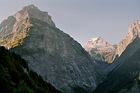
|photo_caption = To the left the 2750 m high Vorder Selbsanft, also known as Hauserhorn, from the upper Linth Valley. [[Tödi]] (middle) in the far back with the prominent summit Sandgipfel (right, 3389 m) and Glarner Tödi (left, 3571 m). And to the right the 2644 m [[Zuetribistock]]. |
|||
| Prominence= |
|||
|elevation_m = 3083 |
|||
| ⚫ | |||
| |
|elevation_ref = |
||
|prominence_m = 180 |
|||
| Easiest route = |
|||
|parent_peak = [[Tödi]] |
|||
|prominence_ref = <ref>Retrieved from the [[Swisstopo]] topographic maps. The key col is the Griessloch (2,849 m).</ref> |
|||
|map = Switzerland |
|||
|map_caption = Location in Switzerland |
|||
|region_type = Canton |
|||
|region = [[Canton of Glarus|Glarus]] |
|||
|country = [[Switzerland]] |
|||
| ⚫ | |||
| ⚫ | |||
|range_coordinates = |
|||
|topo = Swiss Federal Office of Topography [[swisstopo]] |
|||
|first_ascent = |
|||
|easiest_route = |
|||
}} |
}} |
||
The '''Selbsanft''' is a [[mountain massif]] in the [[Glarus Alps]], overlooking the village of [[Linthal, Glarus|Linthal]] in the [[canton of Glarus]]. The Selbsanft is a large mountain massif consisting of several summits of which the highest is named ''Hideri Schibe''. The massif is a buttress of the [[Bifertenstock]] and forms, along with [[Schiben]], the ridge that separates the valleys of the Sand (west) and [[Limmernsee]] (east). A small glacier lies east of the summit.<ref name=swtopo>{{cite map | publisher = Swiss Confederation | title = map.geo.admin.ch | url = http://s.geo.admin.ch/64ef2b1eb6 | accessdate = 2015-06-05}}</ref> |
|||
The five main summits are, from north to south, the '''Vorder Selbsanft''', also known as '''Hauserhorn''' ({{convert|2750|m|ft|0}}, there are higher summits between the Vorder and Mittler Selbsanft, though), '''Mitttler Selbsanft''', also known in Grison as '''Plattas Alvas''' ({{convert|2949|m|ft|0}}), the '''Hinter Selbsanft''' ({{convert|3028|m|ft|0}}), the highest peak of the Selbsanft triple. In a broader sense, the [[Vorderi Schibe]] ({{convert|2987|m|ft|0}}) and the [[Hinderi Schibe]] ({{convert|3083|m|ft|0}}), the highest summit of this massif, re also part of the massif. |
|||
The mountain lies within the municipality of [[Glarus Süd]].<ref name=swtopo/> |
|||
The '''Selbsanft''' is a [[mountain]] in the [[Glarus Alps|Glarus]] [[Swiss Alps|Alps]] in [[Switzerland]]. |
|||
==References== |
|||
{{reflist}} |
|||
==External |
==External links== |
||
*{{commons category-inline|Selbsanft}} |
|||
* [http://www.jo-albis.ch/index.php?menu_id=7 List of mountains above 2000 m in Switzerland with coordinates] |
|||
*[http://www.hikr.org/dir/Selbsanft_4883/ Selbsanft on Hikr] |
|||
[[Category:Mountains of the Alps]] |
[[Category:Mountains of the Alps]] |
||
[[Category:Alpine |
[[Category:Alpine three-thousanders]] |
||
[[Category:Mountains of Switzerland]] |
[[Category:Mountains of Switzerland]] |
||
[[Category:Mountains of the canton of Glarus]] |
|||
{{ |
{{Glarus-geo-stub}} |
||
Latest revision as of 17:49, 3 May 2022
| Selbsanft | |
|---|---|
 To the left the 2750 m high Vorder Selbsanft, also known as Hauserhorn, from the upper Linth Valley. Tödi (middle) in the far back with the prominent summit Sandgipfel (right, 3389 m) and Glarner Tödi (left, 3571 m). And to the right the 2644 m Zuetribistock. | |
| Highest point | |
| Peak | Hinderi Schibe |
| Elevation | 3,083 m (10,115 ft) |
| Prominence | 180 m (590 ft)[1] |
| Parent peak | Tödi |
| Coordinates | 46°49′54.1″N 8°58′41.6″E / 46.831694°N 8.978222°E |
| Naming | |
| Language of name | German |
| Geography | |
| Country | Switzerland |
| Canton | Glarus |
| Parent range | Glarus Alps |
| Topo map | Swiss Federal Office of Topography swisstopo |
The Selbsanft is a mountain massif in the Glarus Alps, overlooking the village of Linthal in the canton of Glarus. The Selbsanft is a large mountain massif consisting of several summits of which the highest is named Hideri Schibe. The massif is a buttress of the Bifertenstock and forms, along with Schiben, the ridge that separates the valleys of the Sand (west) and Limmernsee (east). A small glacier lies east of the summit.[2]
The five main summits are, from north to south, the Vorder Selbsanft, also known as Hauserhorn (2,750 metres (9,022 ft), there are higher summits between the Vorder and Mittler Selbsanft, though), Mitttler Selbsanft, also known in Grison as Plattas Alvas (2,949 metres (9,675 ft)), the Hinter Selbsanft (3,028 metres (9,934 ft)), the highest peak of the Selbsanft triple. In a broader sense, the Vorderi Schibe (2,987 metres (9,800 ft)) and the Hinderi Schibe (3,083 metres (10,115 ft)), the highest summit of this massif, re also part of the massif.
The mountain lies within the municipality of Glarus Süd.[2]
References[edit]
- ^ Retrieved from the Swisstopo topographic maps. The key col is the Griessloch (2,849 m).
- ^ a b map.geo.admin.ch (Map). Swiss Confederation. Retrieved 2015-06-05.
External links[edit]
 Media related to Selbsanft at Wikimedia Commons
- Selbsanft on Hikr

