
Carrera Séptima: Difference between revisions
Content deleted Content added
m (GR) File renamed: File:BOG Eje Ambiental Parque Tercer Mielnio.JPG → File:BOG Eje Ambiental Parque Tercer Milenio.jpg File renaming criterion #5: Correct obvious errors in file names (e.g. incorrect... |
No edit summary Tags: Mobile edit Mobile web edit |
||
| (29 intermediate revisions by 18 users not shown) | |||
| Line 1: | Line 1: | ||
{{Short description|Transit artery in Bogotá, Colombia}} |
|||
{{more citations needed|date=March 2015}} |
|||
{{Expand Spanish|Spanisharticletitle|date=February 2015}} |
{{Expand Spanish|Spanisharticletitle|date=February 2015}} |
||
{{Infobox street |
|||
| ⚫ | |||
| name = Carrera Séptima |
|||
| marker_image = |
|||
| native_name = |
|||
| native_name_lang = |
|||
| alternate_name = |
|||
| image = BOG Eje Ambiental Parque Tercer Milenio.jpg |
|||
| image_size = |
|||
| image_alt = |
|||
| image_map = |
|||
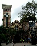
| caption = [[Bolívar Square]] and [[San Francisco Church, Bogotá|San Francisco Church]] on Carrera Séptima |
|||
| map_type = Colombia Bogotá |
|||
| map_size = |
|||
| map_caption = |
|||
| map_alt = |
|||
| other_name = |
|||
| former_names = |
|||
| part_of = |
|||
| namesake = |
|||
| type = |
|||
| owner = |
|||
| maint = |
|||
| length = |
|||
| length_m = |
|||
| length_ft = |
|||
| length_km = |
|||
| length_mi = |
|||
| length_ref = |
|||
| length_notes = |
|||
| width = |
|||
| area = |
|||
| addresses = |
|||
| location = [[Bogotá]]<br>{{COL}} |
|||
| arrondissement = |
|||
| quarter = |
|||
| postal_code = |
|||
| metro = |
|||
| coordinates = {{coord|4|41|34|N|74|01|57|W|display=inline,title}} |
|||
| direction_a = South |
|||
| terminus_a = [[Avenida Primero de Mayo]] |
|||
| direction_b = North |
|||
| terminus_b = [[Autopista Norte (Bogotá)|Autopista Norte]] |
|||
| junction = |
|||
| north = |
|||
| east = |
|||
| south = |
|||
| west = |
|||
| main_contractor = |
|||
| cost = |
|||
| references = |
|||
| commissioning_date = |
|||
| construction_start_date = |
|||
| completion_date = |
|||
| inauguration_date = <!-- {{Start date|YYYY|MM|DD}} --> |
|||
| demolition_date = |
|||
| designer = |
|||
| known_for = |
|||
| status = |
|||
| website = <!-- {{URL|example.com}} --> |
|||
}} |
|||
| ⚫ | '''Carrera Séptima''' (Seventh Street), also known as [[Eduardo Posada Flórez]] Avenue, is one of the principal transit arteries which crosses the eastern side of [[Bogotá]] north and south.<ref>{{cite web|title=The high street.|url=http://www.iberia.com/us/destination-guide/bogota/carrera-7-and-central-zone/|accessdate=25 March 2015}}</ref> It is the most important thoroughfare of the city in the sense of history, culture, economy, and society. Carrera Séptima is bound to the east by the [[Eastern Hills, Bogotá|Eastern Hills]]. |
||
| ⚫ | |||
| ⚫ | |||
| ⚫ | |||
[[File:BOG Eje Ambiental Parque Tercer Milenio.jpg|thumb|[[Bolívar Square]] is visible in the upper left and the Iglesia de San Francisco in the middle bottom.]] |
|||
| ⚫ | |||
| ⚫ | |||
| ⚫ | |||
=== Usaquén === |
=== Usaquén === |
||
* The |
* The Usaquén historic zone |
||
* El Centro Comercial Hacienda Santa Bárbara |
* El Centro Comercial Hacienda Santa Bárbara |
||
* El Centro Empresarial Santa Bárbara |
* El Centro Empresarial Santa Bárbara |
||
* El Cantón Norte del Ejército |
* El Cantón Norte del Ejército |
||
* El |
* El Complejo América Centro Mundial de Negocios |
||
=== Chapinero === |
=== Chapinero === |
||
| Line 25: | Line 84: | ||
=== Santa Fe === |
=== Santa Fe === |
||
* Parque Nacional Enrique Olaya Herrera (Parque Nacional) |
* [[National Park (Bogotá)|Parque Nacional Enrique Olaya Herrera (Parque Nacional)]] |
||
* [[Colombian National Museum|The National Museum of Colombia]] |
* [[Colombian National Museum|The National Museum of Colombia]]<ref>{{cite web|title=Museo Nacional|url=http://www.fodors.com/world/south-america/colombia/bogota/things-to-do/sights/reviews/museo-nacional-107098/|website=Fodor's Travel|publisher=Random House, LLC|accessdate=31 March 2015}}</ref> |
||
* Centro Internacional de Bogotá |
* Centro Internacional de Bogotá |
||
* Centro Comercial Terraza Pasteur |
* Centro Comercial Terraza Pasteur |
||
| Line 32: | Line 91: | ||
* Banco de la República |
* Banco de la República |
||
* Iglesia de Las Nieves |
* Iglesia de Las Nieves |
||
* Iglesia de San Francisco <ref>{{cite web|title=Iglesia de San Francisco|url=http://www.fodors.com/world/south-america/colombia/bogota/things-to-do/sights/reviews/iglesia-de-san-francisco-203978/|website=Fodor's Travel|publisher=Random House, LLC|accessdate=31 March 2015}}</ref> |
|||
* Iglesia de San Francisco |
|||
* Parque Santander |
* Parque Santander |
||
=== La Candelaria === |
=== La Candelaria === |
||
* [[Bolívar Square]]<ref>{{cite web|title=Plaza de Bolívar|url=http://www.fodors.com/world/south-america/colombia/bogota/things-to-do/sights/reviews/plaza-de-bolivar-116151/|website=Fodor's Travel|publisher=Random House, LLC|accessdate=31 March 2015}}</ref> |
|||
* [[Bolívar Square]] |
|||
* [[ |
* [[Primatial Cathedral of Bogotá]] |
||
* [[Capitolio Nacional]] |
* [[Capitolio Nacional]] |
||
* [[Casa de Nariño]]<ref>{{cite web|title=CASA DE NARIÑO|url=http://www.fodors.com/world/south-america/colombia/bogota/things-to-do/sights/reviews/casa-de-narino-137609/|website=Fodor's Travel|publisher=Random House, LLC|accessdate=31 March 2015}}</ref> |
|||
* [[Casa de Nariño]] |
|||
== Gallery == |
|||
{{left|<gallery heights=180px> |
|||
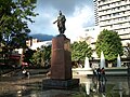
File:Jorge Eliecer Gaitan.jpg|Memorial to [[Jorge Eliécer Gaitán]] |
|||
File:BOG PArque Santander.JPG|Statue of [[Francisco de Paula Santander]] in Santander Park |
|||
File:Bogotá escultura, San Martín, cr 7 cl 29.JPG|[[José de San Martín]] Monument |
|||
File:Iglesia de Nuestra Señora de las Nieves.jpg|Nuestra Señora de las Nieves Church |
|||
File:Vista aérea del Museo Nacional de Colombia (en frente) y la Universidad Colegio Mayor de Cundinamarca (atrás).jpg|[[National Museum of Colombia]] |
|||
</gallery>}} |
|||
{{clearleft}} |
|||
== References == |
|||
{{reflist}} |
|||
| ⚫ | |||
| ⚫ | |||
* {{in lang|es}} [https://web.archive.org/web/20150402113044/http://www.patrimoniocultural.gov.co/component/content/article/320.html Patrimoniocultural.gov] |
|||
{{DEFAULTSORT:Carrera Septima (Bogota)}} |
|||
| ⚫ | |||
[[Category:Streets in Bogotá]] |
|||
| ⚫ | |||
Latest revision as of 22:43, 22 August 2023
This article needs additional citations for verification. (March 2015) |
You can help expand this article with text translated from the corresponding article in Spanish. (February 2015) Click [show] for important translation instructions.
|
 Bolívar Square and San Francisco Church on Carrera Séptima | |
 | |
| Location | Bogotá |
|---|---|
| Coordinates | 4°41′34″N 74°01′57″W / 4.69278°N 74.03250°W |
| South end | Avenida Primero de Mayo |
| North end | Autopista Norte |
Carrera Séptima (Seventh Street), also known as Eduardo Posada Flórez Avenue, is one of the principal transit arteries which crosses the eastern side of Bogotá north and south.[1] It is the most important thoroughfare of the city in the sense of history, culture, economy, and society. Carrera Séptima is bound to the east by the Eastern Hills.
Points of interest[edit]

Carrera Séptima passes through the localities of Usaquén, Chapinero, Santa Fe, and La Candelaria.
Usaquén[edit]
- The Usaquén historic zone
- El Centro Comercial Hacienda Santa Bárbara
- El Centro Empresarial Santa Bárbara
- El Cantón Norte del Ejército
- El Complejo América Centro Mundial de Negocios
Chapinero[edit]
- Parque Museo del Chicó
- Avenida Chile (Calle 72) Financial District
- Universidad Distrital Francisco José de Caldas
- Pontifical Xavierian University
Santa Fe[edit]
- Parque Nacional Enrique Olaya Herrera (Parque Nacional)
- The National Museum of Colombia[2]
- Centro Internacional de Bogotá
- Centro Comercial Terraza Pasteur
- Torre Colpatria
- Banco de la República
- Iglesia de Las Nieves
- Iglesia de San Francisco [3]
- Parque Santander
La Candelaria[edit]
Gallery[edit]
-
 Memorial to Jorge Eliécer Gaitán
 -
 Statue of Francisco de Paula Santander in Santander Park
 -
 José de San Martín Monument
 -
 Nuestra Señora de las Nieves Church
 -


_y_la_Universidad_Colegio_Mayor_de_Cundinamarca_(atr%C3%A1s).jpg)
References[edit]
- ^ "The high street". Retrieved 25 March 2015.
- ^ "Museo Nacional". Fodor's Travel. Random House, LLC. Retrieved 31 March 2015.
- ^ "Iglesia de San Francisco". Fodor's Travel. Random House, LLC. Retrieved 31 March 2015.
- ^ "Plaza de Bolívar". Fodor's Travel. Random House, LLC. Retrieved 31 March 2015.
- ^ "CASA DE NARIÑO". Fodor's Travel. Random House, LLC. Retrieved 31 March 2015.
External links[edit]
Wikimedia Commons has media related to Carrera Séptima.
- (in Spanish) Patrimoniocultural.gov