
Scouten Brook: Difference between revisions
Jakob Coles (talk | contribs) m Jakob Coles moved page User:Jakob Coles/Scouten Brook to Scouten Brook: mainspace Tag: |
Cyphoidbomb (talk | contribs) m Mass revert of Jambleross, a sockpuppet of Bothiman |
||
| (6 intermediate revisions by 5 users not shown) | |||
| Line 4: | Line 4: | ||
|source1_elevation = {{convert|2192|ft|m}} |
|source1_elevation = {{convert|2192|ft|m}} |
||
|mouth_location = Mehoopany Creek in Forkston Township, Wyoming County, Pennsylvania at Kasson Brook |
|mouth_location = Mehoopany Creek in Forkston Township, Wyoming County, Pennsylvania at Kasson Brook |
||
|mouth_coordinates = {{coord|41.48487|-76.13504|type:river_region:US-PA|format=dms|display=inline,title}} |
|||
|mouth_elevation = {{convert|948|ft|m}} |
|mouth_elevation = {{convert|948|ft|m}} |
||
|progression = Mehoopany Creek → [[Susquehanna River]] → [[Chesapeake Bay]] |
|progression = Mehoopany Creek → [[Susquehanna River]] → [[Chesapeake Bay]] |
||
| Line 20: | Line 21: | ||
The elevation near the [[river mouth|mouth]] of Scouten Brook is {{convert|948|ft|m}} above [[sea level]].<ref name = "gnis">{{citation|author = [[Geographic Names Information System]]|url = https://gnis.usgs.gov/apex/f?p=138:3:0::NO::P3_FID,P3_TITLE:1199963,Scouten%20Brook|title = Feature Detail Report for: Scouten Brook|accessdate = July 16, 2017}}</ref> The elevation near the stream's [[river source|source]] is {{convert|2192|ft|m}} above sea level.<ref name = "nationalmap"/> |
The elevation near the [[river mouth|mouth]] of Scouten Brook is {{convert|948|ft|m}} above [[sea level]].<ref name = "gnis">{{citation|author = [[Geographic Names Information System]]|url = https://gnis.usgs.gov/apex/f?p=138:3:0::NO::P3_FID,P3_TITLE:1199963,Scouten%20Brook|title = Feature Detail Report for: Scouten Brook|accessdate = July 16, 2017}}</ref> The elevation near the stream's [[river source|source]] is {{convert|2192|ft|m}} above sea level.<ref name = "nationalmap"/> |
||
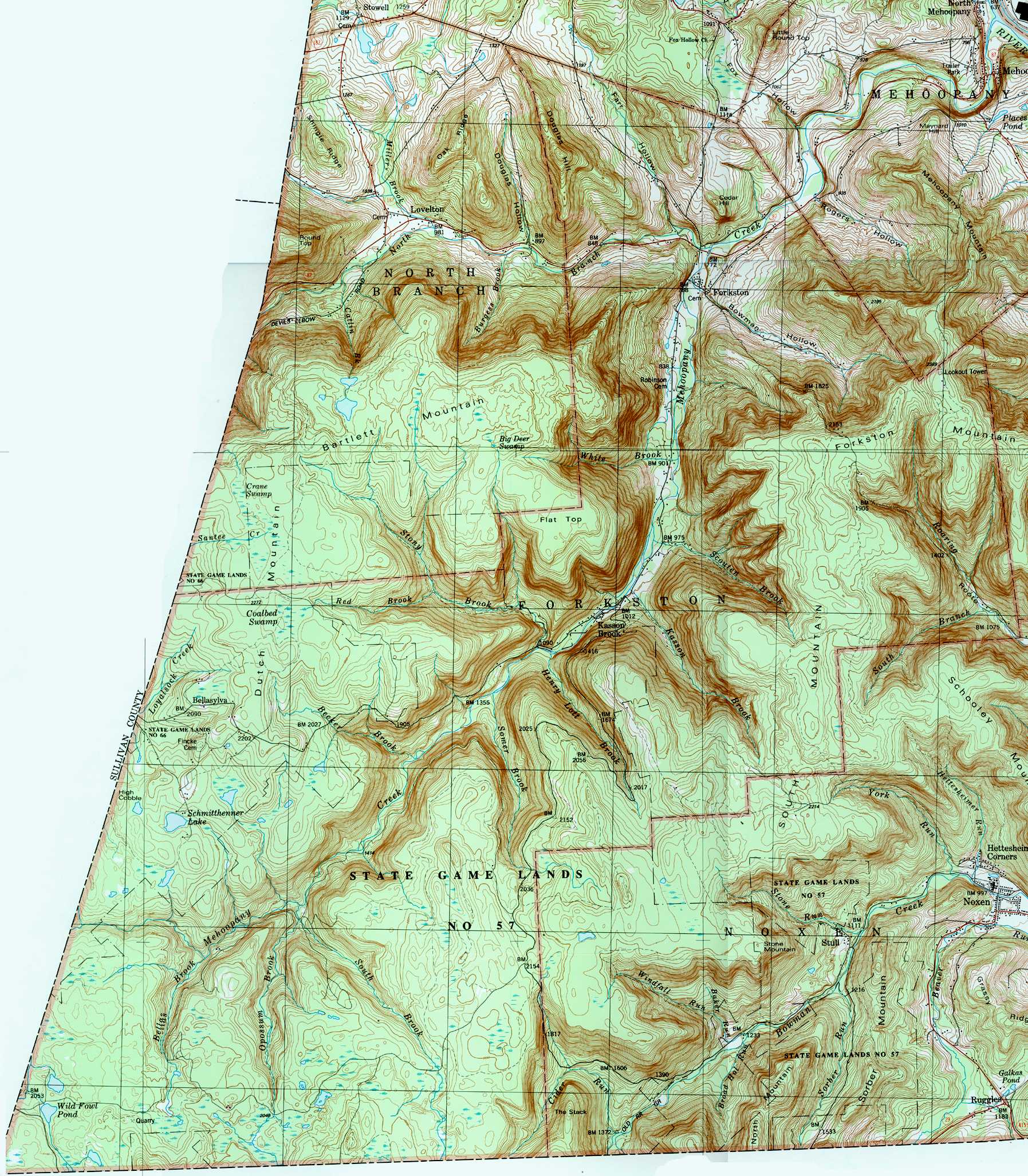
Scouten Brook is one of five large brooks to divide a large, flat-topped mountain along Mehoopany Creek.<ref name = "thegeology"/> This mountain is known as South Mountain and Scouten Brook is the furthest downstream of the five streams. [[Forkston Mountain]] is also situated near the stream.<ref>{{citation|author = [[United States Geological Survey]]|url = http://www.usgwarchives.net/maps/pa/county/wyomin/usgs/forkston.jpg|title = forkston.jpg|year = 1987|accessdate = July 16, 2017}}</ref> In the late 1800s, coal smut was reported at a tract at the headwaters of Scouten Brook.<ref name = "thegeology">{{citation|author = Israel Charles White|title = The Geology of the Susquehanna River Region in the Six Counties |
Scouten Brook is one of five large brooks to divide a large, flat-topped mountain along Mehoopany Creek.<ref name = "thegeology"/> This mountain is known as South Mountain and Scouten Brook is the furthest downstream of the five streams. [[Forkston Mountain]] is also situated near the stream.<ref>{{citation|author = [[United States Geological Survey]]|url = http://www.usgwarchives.net/maps/pa/county/wyomin/usgs/forkston.jpg|title = forkston.jpg|year = 1987|accessdate = July 16, 2017}}</ref> In the late 1800s, coal smut was reported at a tract at the headwaters of Scouten Brook.<ref name = "thegeology">{{citation|author = Israel Charles White|url = https://books.google.com/books?id=POUbAAAAMAAJ&pg=PA406|title = The Geology of the Susquehanna River Region in the Six Counties|volume=25|pages = 406–407|year = 1883|accessdate = July 16, 2017}}</ref> |
||
==Watershed and biology== |
==Watershed and biology== |
||
The [[drainage basin|watershed]] of Scouten Brook has an area of {{convert|2.66|sqmi|km2}}.<ref name = "gaz"/> The mouth of the stream is in the [[United States Geological Survey]] quadrangle of Dutch Mountain. However, its source is in the [[quadrangle (geography)|quadrangle]] of Noxen.<ref name = "gnis"/> The mouth of the stream is located at Kasson Brook and is {{convert|2|mi|km}} south of [[Forkston, Pennsylvania|Forkston]].<ref name = "gaz"/><ref name = "thegeology"/> |
The [[drainage basin|watershed]] of Scouten Brook has an area of {{convert|2.66|sqmi|km2}}.<ref name = "gaz"/> The mouth of the stream is in the [[United States Geological Survey]] quadrangle of Dutch Mountain. However, its source is in the [[quadrangle (geography)|quadrangle]] of Noxen.<ref name = "gnis"/> The mouth of the stream is located at Kasson Brook and is {{convert|2|mi|km}} south of [[Forkston, Pennsylvania|Forkston]].<ref name = "gaz"/><ref name = "thegeology"/> |
||
Wild [[trout]] naturally reproduce in Scouten Brook from its headwaters downstream to its mouth.<ref>{{Citation|author = [[Pennsylvania Fish and Boat Commission]]|url = http://www.fishandboat.com/Fish/PennsylvaniaFishes/Trout/Documents/trout_repro.pdf|title = Pennsylvania Wild Trout Waters (Natural Reproduction) - May 2017|page = 96|date = May 2017|accessdate = July 16, 2017}}</ref> The stream is classified as a High-Quality Coldwater Fishery.<ref>{{citation| |
Wild [[trout]] naturally reproduce in Scouten Brook from its headwaters downstream to its mouth.<ref>{{Citation|author = [[Pennsylvania Fish and Boat Commission]]|url = http://www.fishandboat.com/Fish/PennsylvaniaFishes/Trout/Documents/trout_repro.pdf|title = Pennsylvania Wild Trout Waters (Natural Reproduction) - May 2017|page = 96|date = May 2017|accessdate = July 16, 2017}}</ref> The stream is classified as a High-Quality Coldwater Fishery.<ref>{{citation|author1 = [[Pennsylvania Environmental Council]]|author2= Wyoming County Office of Community Planning|author3=Mehoopany Creek Watershed Association|url = http://pecpa.org/wp-content/uploads/Mehoopany-Creek-and-Little-Mehoopany-Creek-Watersheds.pdf|title = Mehoopany Creek and Little Mehoopany Creek Watersheds Rivers Conservation Plan|page = 17|date = March 31, 2007|accessdate = July 16, 2017}}</ref> |
||
==History== |
==History== |
||
| Line 42: | Line 43: | ||
==External links== |
==External links== |
||
*[http://www.pawaterfalls.com/scouten_brook.html Scouten Brook waterfalls] |
*[http://www.pawaterfalls.com/scouten_brook.html Scouten Brook waterfalls] |
||
[[Category:Tributaries of Mehoopany Creek]] |
|||
Latest revision as of 03:02, 13 August 2019
| Scouten Brook | |
|---|---|
| Physical characteristics | |
| Source | |
| • location | South Mountain in Forkston Township, Wyoming County, Pennsylvania |
| • elevation | 2,192 feet (668 m) |
| Mouth | |
• location | Mehoopany Creek in Forkston Township, Wyoming County, Pennsylvania at Kasson Brook |
• coordinates | 41°29′06″N 76°08′06″W / 41.48487°N 76.13504°W |
• elevation | 948 feet (289 m) |
| Length | 2.2 miles (3.5 km) |
| Basin size | 2.66 square miles (6.9 km2) |
| Basin features | |
| Progression | Mehoopany Creek → Susquehanna River → Chesapeake Bay |
| Tributaries | |
| • right | one unnamed tributary |
Scouten Brook is a tributary of Mehoopany Creek in Wyoming County, Pennsylvania, in the United States. It is approximately 2.2 miles (3.5 km) long and flows through Forkston Township.[1] The watershed of the stream has an area of 2.66 square miles (6.9 km2). The stream is designated as a High-Quality Coldwater Fishery and has wild trout. It is one of five large brooks to cut through South Mountain.
Course[edit]
Scouten Brook begins on South Mountain in Forkston Township. It flows north-northwest for several tenths of a mile before entering a valley and turning northwest for about a mile. The stream then receives an unnamed tributary from the right and turns west-northwest for several tenths of a mile. It then turns west for several tenths of a mile, leaving its valley, crossing Windy Valley Road, and reaching its confluence with Mehoopany Creek.[1]
Scouten Brook joins Mehoopany Creek 10.14 miles (16.32 km) upstream of its mouth.[2]
Geography and geology[edit]
The elevation near the mouth of Scouten Brook is 948 feet (289 m) above sea level.[3] The elevation near the stream's source is 2,192 feet (668 m) above sea level.[1]
Scouten Brook is one of five large brooks to divide a large, flat-topped mountain along Mehoopany Creek.[4] This mountain is known as South Mountain and Scouten Brook is the furthest downstream of the five streams. Forkston Mountain is also situated near the stream.[5] In the late 1800s, coal smut was reported at a tract at the headwaters of Scouten Brook.[4]
Watershed and biology[edit]
The watershed of Scouten Brook has an area of 2.66 square miles (6.9 km2).[2] The mouth of the stream is in the United States Geological Survey quadrangle of Dutch Mountain. However, its source is in the quadrangle of Noxen.[3] The mouth of the stream is located at Kasson Brook and is 2 miles (3.2 km) south of Forkston.[2][4]
Wild trout naturally reproduce in Scouten Brook from its headwaters downstream to its mouth.[6] The stream is classified as a High-Quality Coldwater Fishery.[7]
History[edit]
Scouten Brook was entered into the Geographic Names Information System on August 2, 1979. Its identifier in the Geographic Names Information System is 1199963.[3]
Since 2000, a streambank stabilization project has been done on Scouten Brook.[8]
See also[edit]
- White Brook, next tributary of Mehoopany Creek going downstream
- Kasson Brook, next tributary of Mehoopany Creek going upstream
- List of rivers of Pennsylvania
References[edit]
- ^ a b c United States Geological Survey, The National Map Viewer, retrieved July 16, 2017
- ^ a b c Pennsylvania Gazetteer of Streams (PDF), November 2, 2001, p. 126, retrieved July 16, 2017
- ^ a b c Geographic Names Information System, Feature Detail Report for: Scouten Brook, retrieved July 16, 2017
- ^ a b c Israel Charles White (1883), The Geology of the Susquehanna River Region in the Six Counties, vol. 25, pp. 406–407, retrieved July 16, 2017
- ^ United States Geological Survey (1987), forkston.jpg, retrieved July 16, 2017
- ^ Pennsylvania Fish and Boat Commission (May 2017), Pennsylvania Wild Trout Waters (Natural Reproduction) - May 2017 (PDF), p. 96, retrieved July 16, 2017
- ^ Pennsylvania Environmental Council; Wyoming County Office of Community Planning; Mehoopany Creek Watershed Association (March 31, 2007), Mehoopany Creek and Little Mehoopany Creek Watersheds Rivers Conservation Plan (PDF), p. 17, retrieved July 16, 2017
- ^ Mehoopany Creek Watershed Association (Spring 2013), Newsletter (PDF), p. 1, retrieved July 16, 2017