
Scout Brook
| Scout Brook | ||
|
|
||
| Data | ||
| location | Wyoming County, Pennsylvania, USA | |
| River system | Susquehanna River | |
| Drain over | Mehoopany Creek → Susquehanna River → Chesapeake Bay | |
| source | South Mountain in Forkston Township, Wyoming County, Pennsylvania | |
| Source height | 668 m | |
| muzzle | Mehoopany Creek in Forkston Township, Wyoming County, Pennsylvania near Kasson Brook Coordinates: 41 ° 29 ′ 6 " N , 76 ° 8 ′ 6" W 41 ° 29 ′ 6 " N , 76 ° 8 ′ 6" W |
|
| Mouth height | 289 m | |
| Height difference | 379 m | |
| Bottom slope | 11% | |
| length | 3.5 km | |
| Catchment area | 6.9 km² | |
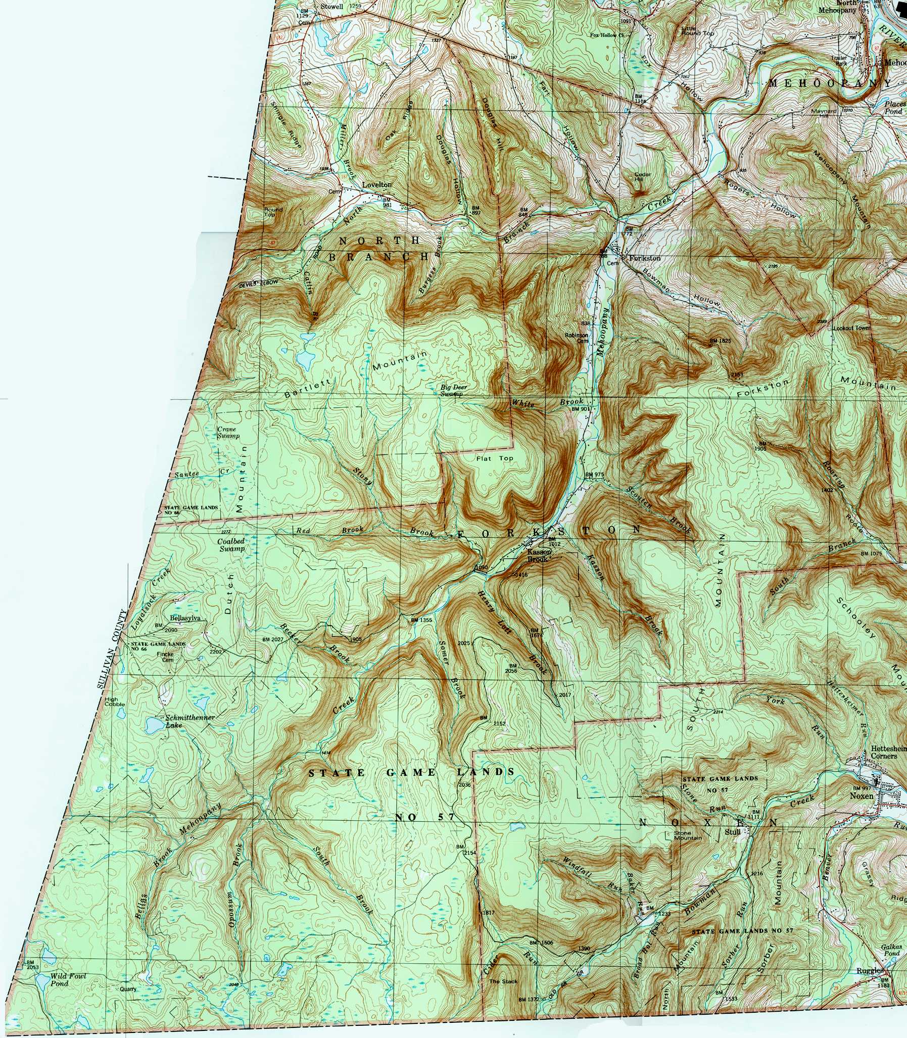
Scouten Brook is a tributary of Mehoopany Creek in Wyoming County, Pennsylvania . It has a length of 3.5 km and runs completely in Forkston Township . The catchment area of the water body has an area of 6.9 km 2 . The creek is classified as cold water fishing waters that are home to trout . It is one of the five major streams on South Mountain.
Run
Scouten Brook has its source on South Mountain in Forkston Township, about 268 m above sea level. The brook follows a north-northwest direction for a few hundred meters before entering a valley and flowing about one and a half kilometers to the northwest. Then an unnamed stream joins from the right . The Scouten Brook then flows west-northwest for a few hundred meters and then west for a few hundred meters, exiting the valley and crossing Windy Valley Road before reaching its confluence with Mehoopany Creek. The mouth of the Scouten Brook is about 289 m above sea level.
Scouten Brook flows into Mehoopany Creek 16.3 km north of its own confluence.
geography
Scouten Brook is one of five major streams that structure a wide mountain along Mehoopany Creek. That mountain is South Mountain, and Scouten Brook is the furthest downstream of it. The Forkston Mountain is located close to the water. At the end of the 19th century, coal dust was found in part of the headwaters.
The catchment area of the Scouten Brook has an area of 6.9 km 2 . The estuary is about 3 km south of Forkston .
A stock of trout is of course preserved in Scouten Brook. The water is classified as cold water fishing water.
A stream stabilization project has been carried out at Scouten Brook since 2000.
See also
- White Brook , Mehoopany Creek's closest tributary downstream
- Kasson Brook , the closest tributary of Mehoopany Creek upstream
- List of rivers in Pennsylvania
supporting documents
- ^ A b Scouten Brook ( English ) In: Geographic Names Information System . United States Geological Survey . Retrieved July 25, 2017.
- ↑ United States Geological Survey (in English). The National Map Viewer . Retrieved July 25, 2017.
- ↑ Pennsylvania Gazetteer of Streams ( English , PDF) p. 126. November 2, 2001. Retrieved July 25, 2017.
- ↑ forkston.jpg ( English ) United States Geological Survey . 1987. Retrieved July 25, 2017.
- ↑ Israel Charles White: The Geology of the Susquehanna River Region in the Six Counties ( English ), vol 25 1883, pages 406-407 (Accessed July 25, 2017).
- ↑ Pennsylvania Fish and Boat Commission : Pennsylvania Wild Trout Waters (Natural Reproduction) - May 2017 ( English , PDF) 96. May 2017. Accessed July 25, 2017th
- ↑ Pennsylvania Environmental Council, Wyoming County Office of Community Planning, Mehoopany Creek Watershed Association: Mehoopany Creek and Little Mehoopany Creek Watershed Rivers Conservation Plan ( English , PDF) 17. March 31, 2007. Accessed July 25, 2017th
- ↑ Mehoopany Creek Watershed Association: Newsletter ( English , PDF) S. 1. Spring 2013. Accessed July 25, 2017.