Cabuyaro: Difference between revisions
Content deleted Content added
Adding geodata: {{coord|4|17|N|72|47|W|display=title|region:CO_type:city_source:GNS-enwiki}} |
m Removing from Category:Populated places in the Meta Department in subcat using Cat-a-lot |
||
| (29 intermediate revisions by 24 users not shown) | |||
| Line 1: | Line 1: | ||
{{Infobox settlement |
|||
| ⚫ | |||
<!-- See Template:Infobox settlement for additional fields and descriptions --> |
|||
|name = Cabuyaro |
|||
|native_name = |
|||
|nickname = |
|||
|motto = |
|||
|settlement_type = [[Municipalities of Colombia|Municipality]] and town |
|||
|image_skyline = Calle_principal_Cabuyaro_Meta.jpg |
|||
|imagesize = |
|||
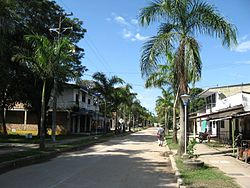
|image_caption = View of Cabuyaro |
|||
|image_flag = Flag of Cabuyaro (Meta).svg |
|||
|image_seal = |
|||
|image_map = Colombia - Meta - Cabuyaro.svg |
|||
|mapsize = 250px |
|||
| ⚫ | |||
|pushpin_map = |
|||
|pushpin_mapsize = 300 |
|||
|pushpin_map_caption = Location in Colombia |
|||
|subdivision_type = Country |
|||
|subdivision_name = {{flag|Colombia}} |
|||
|subdivision_type1 = [[Departments of Colombia|Department]] |
|||
|subdivision_name1 = [[Meta Department]] |
|||
|subdivision_type2 = |
|||
|subdivision_name2 = |
|||
|leader_title = |
|||
|leader_name = |
|||
|established_title = |
|||
|established_date = |
|||
|area_magnitude = |
|||
|area_total_km2 = |
|||
|area_total_sq_mi = |
|||
|area_land_km2 = |
|||
|area_land_sq_mi = |
|||
|area_water_km2 = |
|||
|area_water_sq_mi = |
|||
|area_water_percent = |
|||
|area_urban_km2 = |
|||
|area_urban_sq_mi = |
|||
|area_metro_km2 = |
|||
|area_metro_sq_mi = |
|||
|population_as_of = |
|||
|population_note = |
|||
|population_total = |
|||
|population_density_km2 = |
|||
|population_density_sq_mi = |
|||
|population_metro = |
|||
|population_density_metro_km2 = |
|||
|population_density_metro_sq_mi = |
|||
|population_urban = |
|||
|coordinates = |
|||
|timezone = Colombia Standard Time |
|||
|utc_offset = -5 |
|||
|timezone_DST = |
|||
|utc_offset_DST = |
|||
|elevation_m =180 |
|||
|elevation_ft = |
|||
|blank_name = [[Köppen climate classification|Climate]] |
|||
|blank_info = [[Tropical monsoon climate|Am]] |
|||
|website = |
|||
|footnotes = |
|||
}} |
|||
'''Cabuyaro''' is a town and municipality in the [[Meta Department]], [[Colombia]]. |
'''Cabuyaro''' is a town and municipality in the [[Meta Department]], [[Colombia]]. |
||
| ⚫ | |||
{{Municipalities meta department}} |
{{Municipalities meta department}} |
||
{{coord|4|17|N|72|47|W|display=title|region:CO_type:city_source:GNS-enwiki}} |
{{coord|4|17|N|72|47|W|display=title|region:CO_type:city_source:GNS-enwiki}} |
||
[[Category: |
[[Category:Municipalities of Meta Department]] |
||
[[Category:Municipalities of Meta]] |
|||
| ⚫ | |||
Latest revision as of 15:05, 24 August 2020
Cabuyaro | |
|---|---|
Municipality and town | |
 View of Cabuyaro | |
 Location of the municipality and town of Cabuyaro in the Meta Department of Colombia. | |
| Country | |
| Department | Meta Department |
| Elevation | 180 m (590 ft) |
| Time zone | UTC-5 (Colombia Standard Time) |
| Climate | Am |
Cabuyaro is a town and municipality in the Meta Department, Colombia.

