
Diyala River: Difference between revisions
Adding geodata: {{coord missing|Iran}} |
Ploversegg (talk | contribs) →Archaeology: wl |
||
| (143 intermediate revisions by 81 users not shown) | |||
| Line 1: | Line 1: | ||
{{Infobox river |
|||
{{Unreferenced|date=June 2008}} |
|||
| name = Diyala river |
|||
The '''Diyala River''' ({{lang-ar|نهر ديالى}}, [[Persian language|Persian]]: دیاله, [[Kurdish language|Kurdish]]: '''Sirwan, سيروان''') is a [[river]] and tributary of the [[Tigris]] that runs through [[Kurdistan]] [[Iran]] and [[Iraq]]. It covers a total distance of 445 km (275 miles). |
|||
| image = |
|||
| image_size = |
|||
| image_alt = |
|||
| image_caption = |
|||
| map = |
|||
| map_size = |
|||
| map_alt = |
|||
| map_caption = |
|||
| source1_location = North of Iraq/Western Iran |
|||
| mouth_location = [[Tigris River]] |
|||
| progression = |
|||
| subdivision_type1 = Country |
|||
| subdivision_name1 = [[Iran]], [[Iraq]] |
|||
| location = |
|||
| etymology = |
|||
| length = {{Convert|445|km|mi|abbr=on}} |
|||
| source1_elevation = |
|||
| mouth_elevation = |
|||
| discharge1_avg = {{convert|164|m3/s|cuft/s|abbr=on}} |
|||
| basin_size = {{Convert|32600|km2|mi2|abbr=on}}<ref>{{cite journal|last=Hussein|first=Haitham A.|title=Dependable Discharges of The Upper and Middle Diyala Basins|journal=Journal of Engineering|date=June 2010|volume= 16|issue= 2|pages= 4960–4969|url=http://www.iasj.net/iasj?func=fulltext&aId=24530|access-date= 20 May 2013}}</ref> |
|||
| river_system = |
|||
| tributaries_left = Sirwan |
|||
| tributaries_right = Tanjero |
|||
| custom_label = |
|||
| custom_data = |
|||
}} |
|||
The '''Diyala''' ([[Arabic]]: {{lang|ar|{{script|Arabic|نهر ديالى}}}} {{transl|ar|Nahr Diyālā}}; {{lang-ku|Sîrwan}}; [[Persian language|Farsi]]: {{lang|fa|{{nastaliq|دیاله}}}} {{transl|fa|Diyâlah}}, {{lang|fa|{{nastaliq|سيروان}}}} {{transl|fa|Sīrvān}}) is a [[river]] and tributary of the [[Tigris]]. It is formed by the confluence of the [[Sirwan River|Sirwan]] and [[Tanjaro]] rivers in [[Darbandikhan Dam]] in the [[Sulaymaniyah Governorate]] of Northern Iraq. It covers a total distance of {{convert|445|km|mi|abbr=on}}. |
|||
==Course== |
|||
It rises near [[Sanandaj]], in the [[Zagros Mountains]] of Iran. It then descends through the mountains, where for some 32 km it forms the international border between the two countries. It finally feeds into the Tigris below [[Baghdad]]. |
|||
[[File:Diyala river.PNG|thumb|200px|right|Diyala river]]It rises near [[Hamadan]], in the [[Zagros Mountains]] of Iran. It then descends through the mountains, where for some 32 km it forms the [[Iran–Iraq border|border]] between the two countries. It finally flows into the Tigris below [[Baghdad]]. Navigation of the upper reaches of the Diyala is not possible because of its narrow [[defile (geography)|defile]]s, but the river's valley provides an important trade route between Iran and Iraq. |
|||
The river flows southwest of the [[Hamrin Mountains]]. |
|||
Its origin in Kurdistan and Iran is called Sirwan that means roaring sea, shouting river, it is a name of an ancient city near Ilam city in Iran too. |
|||
Navigation along the upper reaches of the Diyala is not possible because of its narrow [[defile (geography)|defile]]s, but the river's valley provides an important trade route between Iran and Iraq. |
|||
==Name== |
|||
The river is controlled by a dam on the lower Diyala valley, which controls floods and irrigates the area northeast of Baghdad. |
|||
Its Aramaic origin is "Diyalas" and in Kurdish it is called "Sirwan", meaning 'roaring sea' or 'shouting river'. In early Islamic period, the lower course of the river formed part of the [[Nahrawan Canal]]. The [[Diyala Governorate]] in Iraq is named after the river. |
|||
It may be the ancient Tornas river.<ref name=":22">{{Cite book |last=Cohen |first=Getzel M. |title=The Hellenistic settlements in the East from Armenia and Mesopotamia to Bactria and India |date=2013 |publisher=University of California Press |isbn=978-0-520-27382-5 |series=Hellenistic culture and society |location=Berkeley |pages=94}}</ref> |
|||
The [[Diyala Governorate]] in Iraq is named after the river. |
|||
==History== |
|||
[[File:Bil-Sirwan intersection.jpg|thumb|200px|right|Junction of the Bil And Sirwan Riv]]The river is mentioned in [[Herodotus]]' ''[[Histories (Herodotus)|Histories]]'' under the name Gyndes, where it is stated that the king [[Cyrus the Great]] dispersed it by digging 360 channels as punishment after a sacred white horse perished there.<ref>{{cite book|last=Herodotus|publisher=Harvard University Press|translator-last1=Godley|translator-first1=A. D. Godley|title=The Histories|url=http://data.perseus.org/citations/urn:cts:greekLit:tlg0016.tlg001.perseus-eng1:1.189|year=1920}}</ref> The river returned to its former proportions after the channels disappeared under the sand.{{citation needed|date=March 2019}} |
|||
The [[Battle of Diyala River]] took place in 693 BC between the forces of the Assyrian empire and the Elamites of southern Iran. |
|||
In March 1917 the British Empire defeated the Ottoman Empire at the confluence with the Tigris, leading to the [[Fall of Baghdad (1917)|Fall of Baghdad]], part of the Mesopotamian Campaign of World War I. |
|||
==Archaeology== |
|||
This area flourished already during the [[Jemdet Nasr]] and [[Early Dynastic Period (Mesopotamia)|Early Dynastic period]]s, through to the [[Akkadian Empire|Akkadian period]]. During the [[Larsa]] period, [[Eshnunna]] especially became prominent. |
|||
Major excavations were done in the lower Diyala river basin in the 1930s. They were conducted by the [[University of Chicago Oriental Institute]] (1930–1937) and by the [[University of Pennsylvania]] (1938–1939). The sites such as [[Tell Agrab]], Tell Asmar (ancient [[Eshnunna]]), [[Ishchali]] (ancient Neribtum), and Khafaje (ancient [[Tutub]]) were excavated. |
|||
In Tell Asmar, the [[Tell Asmar Hoard]] is particularly notable. Twelve remarkable statues were found belonging to the Early Dynastic period (2900–2350 BC). |
|||
At that time, the Diyala was relatively unexplored compared to southern and northern Mesopotamia. But looting of sites was already underway. As the result, the professional excavations were launched. |
|||
Archaeologists [[James Breasted]] and [[Henri Frankfort]] were leading these projects. |
|||
These excavations provided very comprehensive data on Mesopotamian archaeology and chronology. They covered the time between the late [[Uruk period]] and the end of the [[Old Babylonian period]] (3000–1700 BC). |
|||
Subsequently, nine detailed monographs were published, but most of the objects, numbering 12,000, remained unpublished. Launched in 1992, the Diyala Database Project has been publishing a lot of this material.<ref>[https://oi.uchicago.edu/research/projects/diyala-project Diyala Project] oi.uchicago.edu</ref> |
|||
Other scholars who worked there were [[Thorkild Jacobsen]] as epigrapher, [[Seton Lloyd]], and [[Pinhas Delougaz]].<ref>''POTTERY FROM THE DIYALA REGION''. By Pinhas Delougaz (The University of Chicago, Oriental Institute Publications, vol. LXIII). XXII+182 pp. +204 plates, Chicago 1952.</ref> |
|||
More recently, the Diyala region was also explored intensively as part of the [[Hamrin Dam]] Salvage Project.<ref>McGuire Gibson (ed.), ''Uch Tepe I: Tell Razuk, Tell Ahmed al-Mughir, Tell Ajamat'', Hamrin Reports 10, Copenhagen, 1981.</ref> |
|||
The following sites were excavated from 1977 to 1981: [[Tell Yelkhi]], Tell Hassan, Tell Abu Husaini, Tell Kesaran, Tell Harbud, Tell al-Sarah, and Tell Mahmud.<ref>[http://www.centroscavitorino.it/eng/index.php/projects/iraq/hamrin IRAQ - Hamrin] {{Webarchive|url=https://web.archive.org/web/20181021034450/http://www.centroscavitorino.it/eng/index.php/projects/iraq/hamrin |date=2018-10-21 }} Centro Ricerche Archeologiche e Scavi di Torino per il Medio Oriente e l'Asia</ref> |
|||
===Scarlet Ware=== |
|||
[[File:Painted ceramic jar, 2800-2600 BCE, Khafajah, Sumer EDII-III.jpg|thumb|Scarlet Ware Pottery excavated in [[Khafajah]]. 2800-2600 BCE, Early Dynastic II-III, Sumer. [[British Museum]].<ref>{{cite web |title=Khafajeh jar |url=https://research.britishmuseum.org/research/collection_online/collection_object_details.aspx?objectId=368340&page=3&partId=1&searchText=khafajeh |website=British Museum}}</ref>]] |
|||
A type of pottery known as 'Scarlet Ware', a brightly coloured pottery with pictorial representations, was typical of sites along the Diyala River.<ref>Francesco Del Bravo, [https://www.academia.edu/6624191 'Scarlet Ware': Origins, Chronology and Developments], in M. Lebeau - P. de Miroschedji (eds), ARCANE Interregional Vol. I: Ceramics (ARCANE Interregional I), Turnhout (Brepols), 2014: 131-147</ref> It developed around 2800 BC, and is related to the [[Jemdet Nasr]] ware in central Mesopotamia of the same period. The red colour was achieved predominantly by using [[haematite]] paint. |
|||
Scarlet Ware is typical of [[Early Dynastic Period (Mesopotamia)|Early Dynastic]] I and II periods.<ref>[http://culturalinstitute.britishmuseum.org/asset-viewer/scarlet-ware-jar/qAFq5CoC524QJw?hl=en Scarlet Ware jar] britishmuseum.org</ref> Along the Diyala is located one of the most important trade routes linking south Mesopotamia with the Iranian plateau. Thus, Scarlet ware was also popular in Pusht-i Kuh, [[Luristan]], and it was traded to [[Susa]] during Susa II period. |
|||
==Dams== |
|||
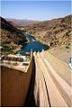
In Iran the [[Daryan Dam]] is constructed near [[Daryan, Kermanshah|Daryan]] in [[Kermanshah Province]]. One of the goals of the dam is to divert a portion of the water to Southwestern Iran for irrigation through the {{Convert|48|km|mi|abbr=on}} long Nosoud Water Conveyance Tunnel and to produce [[hydroelectric]] power.<ref>{{Cite web |title=Darian Dam, one of the best dams in Iran in terms of structure and body |url=https://www.irna.ir/news/82491758/%D8%B3%D8%AF-%D8%AF%D8%A7%D8%B1%D9%8A%D8%A7%D9%86-%D9%8A%D9%83%D9%8A-%D8%A7%D8%B2-%D8%A8%D9%87%D8%AA%D8%B1%D9%8A%D9%86-%D8%B3%D8%AF%D9%87%D8%A7%D9%8A-%D9%83%D8%B4%D9%88%D8%B1-%D8%A8%D9%87-%D9%84%D8%AD%D8%A7%D8%B8-%D8%B3%D8%A7%D8%B2%D9%87-%D9%88-%D8%A8%D8%AF%D9%86%D9%87-%D8%A7%D8%B3%D8%AA |access-date=2024-01-31 |website=www.irna.ir}}</ref><ref>{{cite web|title=Darian Dam|url=http://daminfo.wrm.ir/fa/pageviewreport/1097|publisher=Iran Water Resources Management|access-date=17 May 2013|language=fa|archive-date=2 February 2014|archive-url=https://web.archive.org/web/20140202102833/http://daminfo.wrm.ir/fa/pageviewreport/1097|url-status=dead}}</ref><ref>{{cite web|title=Water Tunnel Nosoud|url=http://www.jtma.ir/fa/projectlist/nonendconstuction/balarooddam|publisher=JTMA|access-date=17 May 2013|language=fa|archive-url=https://web.archive.org/web/20130123151541/http://www.jtma.ir/fa/projectlist/nonendconstuction/balarooddam|archive-date=23 January 2013|url-status=dead}}</ref> In Iraq, the river first reaches the [[Darbandikhan Dam]] which generates hydroelectric power and stores water for irrigation. It then flows down to the [[Hemrin Dam]] for similar purposes. In the lower Diyala Valley near Baghdad the river is controlled by the [[Diyala Weir]] which controls floods and irrigates the area northeast of Baghdad. |
|||
*[[Darbandikhan Dam]], Iraq - water storage capacity: 3,000 MCM |
|||
*[[Bawanur Dam]] (under construction), Iraq - water storage capacity: 31 MCM |
|||
*[[Hemrin Dam]], Iraq - water storage capacity: 2,040 MCM |
|||
*[[Diyala Weir]], Iraq - [[water diversion]] dam |
|||
*[[Garan Dam]], Iran - water storage capacity: 110 MCM |
|||
*[[Daryan Dam]], Iran - water storage capacity: 316 MCM |
|||
<Gallery> |
|||
File:Lake Darbandikhan.jpg|Lake Darbandikhan |
|||
File:Darbandikhan Dam Spillway USACE NWD.jpg|Darbandikhan Dam |
|||
File:Diyala Weir3 USACE NWD.jpg|Diyala Weir |
|||
</gallery> |
|||
==See also== |
==See also== |
||
{{Commons}} |
|||
* [[List of places in Iraq]] |
* [[List of places in Iraq]] |
||
==References== |
|||
{{coord missing|Iran}} |
|||
{{Reflist}} |
|||
[[Category:Rivers of Iraq]] |
|||
[[Category:Rivers of Iran]] |
|||
[[Category:Iraqi Kurdistan]] |
|||
[[Category:Shatt al-Arab basin]] |
|||
{{Authority control}} |
|||
{{Baghdad-stub}} |
|||
{{Iran-geo-stub}} |
|||
{{Iraq-geo-stub}} |
|||
{{Coord|33.2208|N|44.5064|E|source:kolossus-dewiki|display=title}} |
|||
[[ar:نهر ديالى]] |
|||
[[bg:Дияла (река)]] |
|||
[[Category:Rivers of Iraq]] |
|||
[[ca:Diyala]] |
|||
[[Category:Rivers of Iran]] |
|||
[[cv:Дияла (юханшыв)]] |
|||
[[Category:Tributaries of the Tigris River]] |
|||
[[cs:Dijala]] |
|||
[[Category:International rivers of Asia]] |
|||
[[de:Diyala (Fluss)]] |
|||
[[Category:Iran–Iraq border]] |
|||
[[es:Río Diyala]] |
|||
[[Category:Geography of Iraq]] |
|||
[[fr:Diyala]] |
|||
[[Category:Iranian Kurdistan]] |
|||
[[hr:Diyala]] |
|||
[[Category:Diyala Governorate]] |
|||
[[ku:Sîrwan (çem)]] |
|||
[[Category:Landforms of Kurdistan Province]] |
|||
[[lt:Dijala]] |
|||
[[Category:Landforms of Kermanshah Province]] |
|||
[[no:Diyala]] |
|||
[[ru:Дияла (река)]] |
|||
[[sh:Diyala]] |
|||
[[fi:Dijala (joki)]] |
|||
Latest revision as of 19:39, 28 March 2024
| Diyala river | |
|---|---|
 | |
| Location | |
| Country | Iran, Iraq |
| Physical characteristics | |
| Source | |
| • location | North of Iraq/Western Iran |
| Mouth | |
• location | Tigris River |
| Length | 445 km (277 mi) |
| Basin size | 32,600 km2 (12,600 sq mi)[1] |
| Discharge | |
| • average | 164 m3/s (5,800 cu ft/s) |
| Basin features | |
| Tributaries | |
| • left | Sirwan |
| • right | Tanjero |
The Diyala (Arabic: نهر ديالى Nahr Diyālā; Kurdish: Sîrwan; Farsi: دیاله Diyâlah, سيروان Sīrvān) is a river and tributary of the Tigris. It is formed by the confluence of the Sirwan and Tanjaro rivers in Darbandikhan Dam in the Sulaymaniyah Governorate of Northern Iraq. It covers a total distance of 445 km (277 mi).
Course[edit]

It rises near Hamadan, in the Zagros Mountains of Iran. It then descends through the mountains, where for some 32 km it forms the border between the two countries. It finally flows into the Tigris below Baghdad. Navigation of the upper reaches of the Diyala is not possible because of its narrow defiles, but the river's valley provides an important trade route between Iran and Iraq.
The river flows southwest of the Hamrin Mountains.
Name[edit]
Its Aramaic origin is "Diyalas" and in Kurdish it is called "Sirwan", meaning 'roaring sea' or 'shouting river'. In early Islamic period, the lower course of the river formed part of the Nahrawan Canal. The Diyala Governorate in Iraq is named after the river.
It may be the ancient Tornas river.[2]
History[edit]

The river is mentioned in Herodotus' Histories under the name Gyndes, where it is stated that the king Cyrus the Great dispersed it by digging 360 channels as punishment after a sacred white horse perished there.[3] The river returned to its former proportions after the channels disappeared under the sand.[citation needed]
The Battle of Diyala River took place in 693 BC between the forces of the Assyrian empire and the Elamites of southern Iran.
In March 1917 the British Empire defeated the Ottoman Empire at the confluence with the Tigris, leading to the Fall of Baghdad, part of the Mesopotamian Campaign of World War I.
Archaeology[edit]
This area flourished already during the Jemdet Nasr and Early Dynastic periods, through to the Akkadian period. During the Larsa period, Eshnunna especially became prominent.
Major excavations were done in the lower Diyala river basin in the 1930s. They were conducted by the University of Chicago Oriental Institute (1930–1937) and by the University of Pennsylvania (1938–1939). The sites such as Tell Agrab, Tell Asmar (ancient Eshnunna), Ishchali (ancient Neribtum), and Khafaje (ancient Tutub) were excavated.
In Tell Asmar, the Tell Asmar Hoard is particularly notable. Twelve remarkable statues were found belonging to the Early Dynastic period (2900–2350 BC).
At that time, the Diyala was relatively unexplored compared to southern and northern Mesopotamia. But looting of sites was already underway. As the result, the professional excavations were launched.
Archaeologists James Breasted and Henri Frankfort were leading these projects.
These excavations provided very comprehensive data on Mesopotamian archaeology and chronology. They covered the time between the late Uruk period and the end of the Old Babylonian period (3000–1700 BC).
Subsequently, nine detailed monographs were published, but most of the objects, numbering 12,000, remained unpublished. Launched in 1992, the Diyala Database Project has been publishing a lot of this material.[4]
Other scholars who worked there were Thorkild Jacobsen as epigrapher, Seton Lloyd, and Pinhas Delougaz.[5]
More recently, the Diyala region was also explored intensively as part of the Hamrin Dam Salvage Project.[6]
The following sites were excavated from 1977 to 1981: Tell Yelkhi, Tell Hassan, Tell Abu Husaini, Tell Kesaran, Tell Harbud, Tell al-Sarah, and Tell Mahmud.[7]
Scarlet Ware[edit]

A type of pottery known as 'Scarlet Ware', a brightly coloured pottery with pictorial representations, was typical of sites along the Diyala River.[9] It developed around 2800 BC, and is related to the Jemdet Nasr ware in central Mesopotamia of the same period. The red colour was achieved predominantly by using haematite paint.
Scarlet Ware is typical of Early Dynastic I and II periods.[10] Along the Diyala is located one of the most important trade routes linking south Mesopotamia with the Iranian plateau. Thus, Scarlet ware was also popular in Pusht-i Kuh, Luristan, and it was traded to Susa during Susa II period.
Dams[edit]
In Iran the Daryan Dam is constructed near Daryan in Kermanshah Province. One of the goals of the dam is to divert a portion of the water to Southwestern Iran for irrigation through the 48 km (30 mi) long Nosoud Water Conveyance Tunnel and to produce hydroelectric power.[11][12][13] In Iraq, the river first reaches the Darbandikhan Dam which generates hydroelectric power and stores water for irrigation. It then flows down to the Hemrin Dam for similar purposes. In the lower Diyala Valley near Baghdad the river is controlled by the Diyala Weir which controls floods and irrigates the area northeast of Baghdad.
- Darbandikhan Dam, Iraq - water storage capacity: 3,000 MCM
- Bawanur Dam (under construction), Iraq - water storage capacity: 31 MCM
- Hemrin Dam, Iraq - water storage capacity: 2,040 MCM
- Diyala Weir, Iraq - water diversion dam
- Garan Dam, Iran - water storage capacity: 110 MCM
- Daryan Dam, Iran - water storage capacity: 316 MCM
-
 Lake Darbandikhan
 -
 Darbandikhan Dam
 -
 Diyala Weir


See also[edit]
References[edit]
- ^ Hussein, Haitham A. (June 2010). "Dependable Discharges of The Upper and Middle Diyala Basins". Journal of Engineering. 16 (2): 4960–4969. Retrieved 20 May 2013.
- ^ Cohen, Getzel M. (2013). The Hellenistic settlements in the East from Armenia and Mesopotamia to Bactria and India. Hellenistic culture and society. Berkeley: University of California Press. p. 94. ISBN 978-0-520-27382-5.
- ^ Herodotus (1920). The Histories. Translated by Godley, A. D. Godley. Harvard University Press.
- ^ Diyala Project oi.uchicago.edu
- ^ POTTERY FROM THE DIYALA REGION. By Pinhas Delougaz (The University of Chicago, Oriental Institute Publications, vol. LXIII). XXII+182 pp. +204 plates, Chicago 1952.
- ^ McGuire Gibson (ed.), Uch Tepe I: Tell Razuk, Tell Ahmed al-Mughir, Tell Ajamat, Hamrin Reports 10, Copenhagen, 1981.
- ^ IRAQ - Hamrin Archived 2018-10-21 at the Wayback Machine Centro Ricerche Archeologiche e Scavi di Torino per il Medio Oriente e l'Asia
- ^ "Khafajeh jar". British Museum.
- ^ Francesco Del Bravo, 'Scarlet Ware': Origins, Chronology and Developments, in M. Lebeau - P. de Miroschedji (eds), ARCANE Interregional Vol. I: Ceramics (ARCANE Interregional I), Turnhout (Brepols), 2014: 131-147
- ^ Scarlet Ware jar britishmuseum.org
- ^ "Darian Dam, one of the best dams in Iran in terms of structure and body". www.irna.ir. Retrieved 2024-01-31.
- ^ "Darian Dam" (in Persian). Iran Water Resources Management. Archived from the original on 2 February 2014. Retrieved 17 May 2013.
- ^ "Water Tunnel Nosoud" (in Persian). JTMA. Archived from the original on 23 January 2013. Retrieved 17 May 2013.