Nowe Sioło: Difference between revisions
Appearance
Content deleted Content added
m →top: unsourced/poorly sourced/unnecessary, removed: has a population, {{lang-uk| |
m Merge coordinate templates (AWB) |
||
| Line 16: | Line 16: | ||
| subdivision_name3 = [[Gmina Cieszanów|Cieszanów]] |
| subdivision_name3 = [[Gmina Cieszanów|Cieszanów]] |
||
|pushpin_map=Poland |
|pushpin_map=Poland |
||
|coordinates = {{coord|50|13|N|23|9|E|region:PL|display=inline}} |
|coordinates = {{coord|50|13|N|23|9|E|region:PL|display=title,inline}} |
||
| elevation_m = |
| elevation_m = |
||
| population_total = 1300 |
| population_total = 1300 |
||
| Line 29: | Line 29: | ||
{{Authority control}} |
{{Authority control}} |
||
{{Coord|50|13|N|23|09|E|source:plwiki_region:PL_scale:10000|display=title}} |
|||
{{DEFAULTSORT:Nowe Siolo}} |
{{DEFAULTSORT:Nowe Siolo}} |
||
Revision as of 04:19, 19 November 2023
Nowe Sioło | |
|---|---|
Village | |
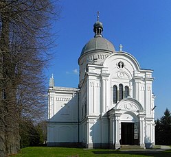
 Former Greek Catholic church of the Prophet Elijah. Currently Roman Catholic church of the Assumption of the Virgin Mary. | |
| Coordinates: 50°13′N 23°9′E / 50.217°N 23.150°E | |
| Country | |
| Voivodeship | Subcarpathian |
| County | Lubaczów |
| Gmina | Cieszanów |
| Population | 1,300 |
Nowe Sioło [ˈnɔvɛ ˈɕɔwɔ] is a village in the administrative district of Gmina Cieszanów, within Lubaczów County, Subcarpathian Voivodeship, in south-eastern Poland.[1] It lies approximately 6 kilometres (4 mi) south of Cieszanów, 7 km (4 mi) north-east of Lubaczów, and 85 km (53 mi) east of the regional capital Rzeszów.
References


