Santa Luzia do Itanhy: Difference between revisions
Content deleted Content added
m Fixed typos (via WP:JWB) |
|||
| Line 1: | Line 1: | ||
{{coord|11|21|03|S|37|26|52|W|scale:30000|display=title}} |
{{coord|11|21|03|S|37|26|52|W|scale:30000|display=title}} |
||
'''Santa Luzia do Itanhy''' is a [[Municipalities of Brazil|municipality]] located in the [[States of Brazil|Brazilian state]] of [[Sergipe]]. Its population was 14,121 (2020)<ref>{{cite web |title=IBGE 2020 |url=https://cidades.ibge.gov.br/brasil/se/santa-luzia-do-itanhy/panorama |access-date=26 January 2021}}</ref> and its area is 330 km |
'''Santa Luzia do Itanhy''' is a [[Municipalities of Brazil|municipality]] located in the [[States of Brazil|Brazilian state]] of [[Sergipe]]. Its population was 14,121 (2020)<ref>{{cite web |title=IBGE 2020 |url=https://cidades.ibge.gov.br/brasil/se/santa-luzia-do-itanhy/panorama |access-date=26 January 2021}}</ref> and its area is 330 km<sup>2</sup>.<ref>[[Brazilian Institute of Geography and Statistics|IBGE]] - [http://www.ibge.gov.br/cidadesat/default.php]</ref> |
||
==References== |
==References== |
||
Latest revision as of 21:18, 12 April 2024
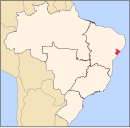
11°21′03″S 37°26′52″W / 11.35083°S 37.44778°W Santa Luzia do Itanhy is a municipality located in the Brazilian state of Sergipe. Its population was 14,121 (2020)[1] and its area is 330 km2.[2]
References[edit]
- ^ "IBGE 2020". Retrieved 26 January 2021.
- ^ IBGE - [1]

